Property Record
1675 W Baseline Rd, Tempe, AZ 85283
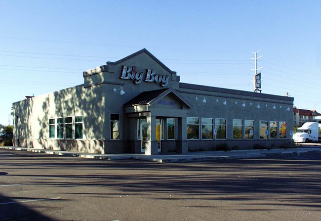

Property Detail
1675 W Baseline Rd
301-10-012P
E 480F OF W 580F LY N OF NLY R/W LN HIGHLINE CAN OF LT 1 OR NE4 NE4 EX N 65F RD & EX S 200F OF N 265F OF W 280F TH/OF & EX ANY PT CONV P/F 94-0341306
Bartavern
Maricopa
C-G
Arizona
C and X Area of minimal flood hazard, usually depicted on FIRMs as above the 500-year flood level.
1
2025
1.29 AC
2025
Tempe
320002
Phoenix
8,183 SF
Phoenix-Mesa-Chandler, AZ
NEARBY LISTINGS FOR SALE OR LEASE
DEMOGRAPHICS near 1675 W Baseline Rd
1 mile
3 mile
5 mile
2025 Total Population
18,447
109,421
294,595
2030 Population
19,047
112,905
304,853
Pop Growth 2025-2030
+ 3.25%
+ 3.18%
+ 3.48%
Average Age
36
37
37
2025 Total Households
7,466
44,916
118,334
HH Growth 2025-2030
+ 3.40%
+ 3.28%
+ 3.74%
Median Household Inc
$73,187
$80,888
$83,477
Avg Household Size
2.40
2.40
2.30
2025 Avg HH Vehicles
2.00
2.00
2.00
Median Home Value
$313,962
$420,246
$464,585
Median Year Built
1984
1981
1986
Nearby Places
Map Layers
Map Styles
 Street
 Aerial
Transit
 Traffic
 Biking
Places
Listings with unknown addresses are not visible on the map
- Restaurants
- Banks
- Shops
- Fitness
- Groceries
PUBLIC TRANSPORTATION
AIRPORT
Phoenix Sky Harbor International
Drive
Walk
Distance
Phoenix Sky Harbor International
13 min
6.8 mi
Phoenix-Mesa Gateway
Drive
Walk
Distance
Phoenix-Mesa Gateway
34 min
23.6 mi
Nearby Properties
Address
Land Use
TOTAL SIZE
Lot Size
Zoning
Address
Land Use
TOTAL SIZE
Lot Size
Zoning
12.93 AC
I-P
Address
Land Use
TOTAL SIZE
Lot Size
Zoning
5.13 AC
Address
Land Use
TOTAL SIZE
Lot Size
Zoning
1,479,006 SF
84.96 AC
C-R
Address
Land Use
TOTAL SIZE
Lot Size
Zoning
1,020,776 SF
11.33 AC
I-1
Address
Land Use
TOTAL SIZE
Lot Size
Zoning
331,050 SF
39 AC
I-1
Address
Land Use
TOTAL SIZE
Lot Size
Zoning
32,968 SF
2.10 AC
I-P
Address
Land Use
TOTAL SIZE
Lot Size
Zoning
746,457 SF
20.95 AC
I-1
Address
Land Use
TOTAL SIZE
Lot Size
Zoning
180,690 SF
11.20 AC
I-P
Address
Land Use
TOTAL SIZE
Lot Size
Zoning
442,642 SF
35.15 AC
GID
Address
Land Use
TOTAL SIZE
Lot Size
Zoning
586,083 SF
69.82 AC
Address
Land Use
TOTAL SIZE
Lot Size
Zoning
378,731 SF
8.68 AC
I-1
Address
Land Use
TOTAL SIZE
Lot Size
Zoning
415,228 SF
19.48 AC
I-1
Address
Land Use
TOTAL SIZE
Lot Size
Zoning
756,193 SF
23.40 AC
I-1
Address
Land Use
TOTAL SIZE
Lot Size
Zoning
309.82 AC
R-35
Address
Land Use
TOTAL SIZE
Lot Size
Zoning
283,782 SF
25.29 AC
I-1
Address
Land Use
TOTAL SIZE
Lot Size
Zoning
230,853 SF
23.41 AC
C-R
Address
Land Use
TOTAL SIZE
Lot Size
Zoning
301,102 SF
27.45 AC
Address
Land Use
TOTAL SIZE
Lot Size
Zoning
428,895 SF
14.66 AC
PAD
Address
Land Use
TOTAL SIZE
Lot Size
Zoning
317,115 SF
36.47 AC
R-6
Address
Land Use
TOTAL SIZE
Lot Size
Zoning
282,793 SF
31.08 AC
R-6
Address
Land Use
TOTAL SIZE
Lot Size
Zoning
309,057 SF
7.62 AC
I-1
Address
Land Use
TOTAL SIZE
Lot Size
Zoning
355,299 SF
10.01 AC
I-1
Address
Land Use
TOTAL SIZE
Lot Size
Zoning
569,902 SF
42.47 AC
I-1
Address
Land Use
TOTAL SIZE
Lot Size
Zoning
387,347 SF
18.83 AC
M-H
Address
Land Use
TOTAL SIZE
Lot Size
Zoning
442,003 SF
24.85 AC
M-H
Address
Land Use
TOTAL SIZE
Lot Size
Zoning
39,250 SF
119.46 AC
R1-6
Address
Land Use
TOTAL SIZE
Lot Size
Zoning
369,672 SF
22.28 AC
M-H
Address
Land Use
TOTAL SIZE
Lot Size
Zoning
762,657 SF
42.85 AC
I-1
Address
Land Use
TOTAL SIZE
Lot Size
Zoning
353,363 SF
21.29 AC
A-1
Address
Land Use
TOTAL SIZE
Lot Size
Zoning
112,968 SF
10.55 AC
R-43AG
The World's #1 Commercial Real Estate Marketplace
Connect with us
© 2026 CoStar Group
The information above has been obtained from sources believed reliable. While we do not doubt its accuracy we have not verified it and make no guarantee, warranty or representation about it. It is your responsibility to independently confirm its accuracy and completeness. Any projections, opinions, assumptions, or estimates used are for example only and do not represent the current or future performance of the property. The value of this transaction to you depends on tax and other factors which should be evaluated by your tax, financial, and legal advisors. You and your advisors should conduct a careful, independent investigation of the property to determine to your satisfaction the suitability of the property for your needs.