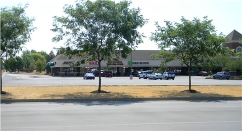
Property Record
1675 W Smith Valley Rd, Greenwood, IN 46142


NEARBY LISTINGS FOR SALE OR LEASE
Property Detail
1675 W Smith Valley Rd
Indianapolis-Carmel-Greenwood, IN
Center Smith Valley Sub
41-04-01-022-036.001-041
CENTRE AT SMITH VALLEY OT 2
Parkinglot
Johnson
X
Indiana
18081C0106E
0.94 AC
2024
Greenwood
2025
Indianapolis
610605
DEMOGRAPHICS near 1675 W Smith Valley Rd
1 Mile
3 Mile
5 Mile
2024 Total Population
9,096
73,773
164,612
2029 Population
9,629
77,656
170,041
Pop Growth 2024-2029
+ 5.86%
+ 5.26%
+ 3.30%
Average Age
39
39
38
2024 Total Households
3,463
28,013
62,514
HH Growth 2024-2029
+ 6.04%
+ 5.37%
+ 3.36%
Median Household Inc
$81,739
$80,832
$76,387
Avg Household Size
2.50
2.60
2.60
2024 Avg HH Vehicles
2.00
2.00
2.00
Median Home Value
$245,114
$242,903
$225,120
Median Year Built
1993
1990
1989
Nearby Places
Map Layers
Map Styles
 Street
 Aerial
- Restaurants
- Banks
- Shops
- Fitness
- Groceries
PUBLIC TRANSPORTATION
AIRPORT
Indianapolis International
DRIVE
WALK
Distance
Indianapolis International
36 min
21.4 mi
Freight Ports
Port of Toledo
DRIVE
WALK
Distance
Port of Toledo
288 min
239.2 mi
SALE & LEASE HISTORY
LISTING DATE
SALE/LEASE

Sep 24, 2016
For Sale
Nov 03, 2020
For Lease
May 23, 2017
For Sale
Nearby Properties
Address
Land Use
TOTAL SIZE
Lot Size
Zoning
Address
Land Use
TOTAL SIZE
Lot Size
Zoning
295,161 SF
70.54 AC
Address
Land Use
TOTAL SIZE
Lot Size
Zoning
4,582 SF
30.22 AC
R4
Address
Land Use
TOTAL SIZE
Lot Size
Zoning
39,866 SF
19.99 AC
Address
Land Use
TOTAL SIZE
Lot Size
Zoning
56,520 SF
35.65 AC
Address
Land Use
TOTAL SIZE
Lot Size
Zoning
3,286 SF
26.39 AC
Address
Land Use
TOTAL SIZE
Lot Size
Zoning
3,346 SF
21.35 AC
Address
Land Use
TOTAL SIZE
Lot Size
Zoning
23,040 SF
9.28 AC
ZO01
Address
Land Use
TOTAL SIZE
Lot Size
Zoning
4,478 SF
12.05 AC
Address
Land Use
TOTAL SIZE
Lot Size
Zoning
33,790 SF
13.01 AC
Address
Land Use
TOTAL SIZE
Lot Size
Zoning
226,129 SF
18.69 AC
ZO01
Address
Land Use
TOTAL SIZE
Lot Size
Zoning
1,102 SF
9.98 AC
Address
Land Use
TOTAL SIZE
Lot Size
Zoning
11,546 SF
14.18 AC
Address
Land Use
TOTAL SIZE
Lot Size
Zoning
3,793 SF
23.47 AC
ZO01
Address
Land Use
TOTAL SIZE
Lot Size
Zoning
176,228 SF
1.57 AC
Address
Land Use
TOTAL SIZE
Lot Size
Zoning
3,296 SF
21 AC
Address
Land Use
TOTAL SIZE
Lot Size
Zoning
3,701 SF
26 AC
ZO01
Address
Land Use
TOTAL SIZE
Lot Size
Zoning
69,444 SF
2.99 AC
Address
Land Use
TOTAL SIZE
Lot Size
Zoning
6,272 SF
21.91 AC
Address
Land Use
TOTAL SIZE
Lot Size
Zoning
108,092 SF
23.62 AC
ZO01
Address
Land Use
TOTAL SIZE
Lot Size
Zoning
3,168 SF
8.62 AC
Address
Land Use
TOTAL SIZE
Lot Size
Zoning
152,664 SF
14.82 AC
Address
Land Use
TOTAL SIZE
Lot Size
Zoning
3,406 SF
20.34 AC
Address
Land Use
TOTAL SIZE
Lot Size
Zoning
4,982 SF
15.06 AC
R4
Address
Land Use
TOTAL SIZE
Lot Size
Zoning
3,257 SF
19.49 AC
Address
Land Use
TOTAL SIZE
Lot Size
Zoning
82,619 SF
13.50 AC
Address
Land Use
TOTAL SIZE
Lot Size
Zoning
173,052 SF
17.35 AC
Address
Land Use
TOTAL SIZE
Lot Size
Zoning
748 SF
6.83 AC
Address
Land Use
TOTAL SIZE
Lot Size
Zoning
3,360 SF
14.68 AC
Address
Land Use
TOTAL SIZE
Lot Size
Zoning
69,215 SF
4.90 AC
B1
Address
Land Use
TOTAL SIZE
Lot Size
Zoning
98,409 SF
8.82 AC
The World's #1 Commercial Real Estate Marketplace
Connect with us
© 2026 CoStar Group
The information above has been obtained from sources believed reliable. While we do not doubt its accuracy we have not verified it and make no guarantee, warranty or representation about it. It is your responsibility to independently confirm its accuracy and completeness. Any projections, opinions, assumptions, or estimates used are for example only and do not represent the current or future performance of the property. The value of this transaction to you depends on tax and other factors which should be evaluated by your tax, financial, and legal advisors. You and your advisors should conduct a careful, independent investigation of the property to determine to your satisfaction the suitability of the property for your needs.