Property Record
1676 Freeport Rd, Kittanning, PA 16201

Save to a Folder
{{folder.Name}}
{{folder.ListingIds.length}} Properties
{{folder.ListingIds.length}} Property
Create a New Folder
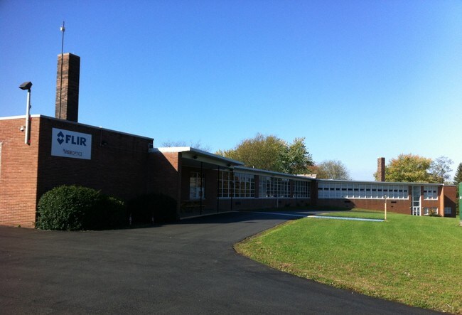
Property Detail
1676 Freeport Rd
32-0-023536
MAP NO:140.00-02-14; 6.88A IMPRS
Commercialnec
Armstrong
B and X Area of moderate flood hazard, usually the area between the limits of the 100-year and 500-year floods.
Pennsylvania
2026
6.88 AC
2026
Armstrong County
951200
Pittsburgh
21,513 SF
Pittsburgh, PA
NEARBY LISTINGS FOR SALE OR LEASE
DEMOGRAPHICS near 1676 Freeport Rd
1 mile
3 mile
5 mile
2025 Total Population
342
3,003
19,583
2030 Population
331
2,897
19,048
Pop Growth 2025-2030
(3.22%)
(3.53%)
(2.73%)
Average Age
47
46
45
2025 Total Households
141
1,266
8,688
HH Growth 2025-2030
(3.55%)
(3.55%)
(2.73%)
Median Household Inc
$72,161
$74,717
$67,531
Avg Household Size
2.30
2.30
2.20
2025 Avg HH Vehicles
2.00
2.00
2.00
Median Home Value
$191,378
$183,469
$158,957
Median Year Built
1966
1969
1956
Nearby Places
Map Layers
Map Styles
 Street
 Aerial
Layers
 Traffic
 Biking
Places
Listings with unknown addresses are not visible on the map
- Restaurants
- Banks
- Shops
- Fitness
- Groceries
SALE & LEASE HISTORY
LISTING DATE
SALE/LEASE

Sep 23, 2016
For Sale
Jan 25, 2019
For Sale
Jan 10, 2019
For Lease
Nearby Properties
Address
Land Use
TOTAL SIZE
Lot Size
Zoning
Address
Land Use
TOTAL SIZE
Lot Size
Zoning
233,203 SF
9.93 AC
Address
Land Use
TOTAL SIZE
Lot Size
Zoning
44,000 SF
37.30 AC
Address
Land Use
TOTAL SIZE
Lot Size
Zoning
37,066 SF
60.59 AC
Address
Land Use
TOTAL SIZE
Lot Size
Zoning
23,999 SF
5.43 AC
Address
Land Use
TOTAL SIZE
Lot Size
Zoning
45,373 SF
5.36 AC
Address
Land Use
TOTAL SIZE
Lot Size
Zoning
42,795 SF
7.89 AC
INDUSTRIAL
Address
Land Use
TOTAL SIZE
Lot Size
Zoning
34,415 SF
8.54 AC
Address
Land Use
TOTAL SIZE
Lot Size
Zoning
31,104 SF
7.22 AC
Address
Land Use
TOTAL SIZE
Lot Size
Zoning
4,680 SF
452.30 AC
Address
Land Use
TOTAL SIZE
Lot Size
Zoning
51,284 SF
7 AC
INDUSTRIAL
Address
Land Use
TOTAL SIZE
Lot Size
Zoning
18,304 SF
209.96 AC
Address
Land Use
TOTAL SIZE
Lot Size
Zoning
19,800 SF
5.80 AC
INDUSTRIAL
Address
Land Use
TOTAL SIZE
Lot Size
Zoning
12,680 SF
6.30 AC
INDUSTRIAL
Address
Land Use
TOTAL SIZE
Lot Size
Zoning
62,060 SF
3.41 AC
INDUSTRIAL
Address
Land Use
TOTAL SIZE
Lot Size
Zoning
30,120 SF
3.51 AC
Address
Land Use
TOTAL SIZE
Lot Size
Zoning
25,088 SF
3.50 AC
INDUSTRIAL
Address
Land Use
TOTAL SIZE
Lot Size
Zoning
22,698 SF
12.33 AC
INDUSTRIAL
Address
Land Use
TOTAL SIZE
Lot Size
Zoning
8,472 SF
2.70 AC
Address
Land Use
TOTAL SIZE
Lot Size
Zoning
10,350 SF
2.22 AC
BUSINESS
Address
Land Use
TOTAL SIZE
Lot Size
Zoning
20,800 SF
5.16 AC
Address
Land Use
TOTAL SIZE
Lot Size
Zoning
30,000 SF
4.79 AC
INDUSTRIAL
Address
Land Use
TOTAL SIZE
Lot Size
Zoning
12,636 SF
1 AC
BUSINESS
Address
Land Use
TOTAL SIZE
Lot Size
Zoning
3,073 SF
4.25 AC
Address
Land Use
TOTAL SIZE
Lot Size
Zoning
Address
Land Use
TOTAL SIZE
Lot Size
Zoning
9,605 SF
2.61 AC
INDUSTRIAL
Address
Land Use
TOTAL SIZE
Lot Size
Zoning
106.25 AC
RESIDENTIA
Address
Land Use
TOTAL SIZE
Lot Size
Zoning
10,000 SF
2.05 AC
Address
Land Use
TOTAL SIZE
Lot Size
Zoning
298.70 AC
AGRICULTUR
Address
Land Use
TOTAL SIZE
Lot Size
Zoning
6,868 SF
2 AC
INDUSTRIAL
Address
Land Use
TOTAL SIZE
Lot Size
Zoning
10,178 SF
0.73 AC
The World's #1 Commercial Real Estate Marketplace
Connect with us
© 2026 CoStar Group
The information above has been obtained from sources believed reliable. While we do not doubt its accuracy we have not verified it and make no guarantee, warranty or representation about it. It is your responsibility to independently confirm its accuracy and completeness. Any projections, opinions, assumptions, or estimates used are for example only and do not represent the current or future performance of the property. The value of this transaction to you depends on tax and other factors which should be evaluated by your tax, financial, and legal advisors. You and your advisors should conduct a careful, independent investigation of the property to determine to your satisfaction the suitability of the property for your needs.