Property Record
1677 Us 41 Byp S, Venice, FL 34293

NEARBY LISTINGS FOR SALE OR LEASE
Property Detail
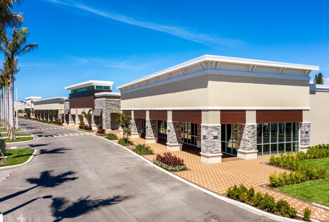
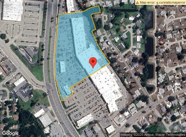
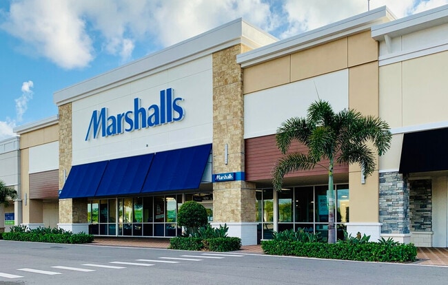
1677 Us 41 Byp S
0433-02-0042
Not Part Of A Subdivision
Regionalshoppingcenterormallwithanchorstore
COM NE COR SEC 20-39-19, TH N 88-46-50 W 2390.82 FT TO E R/W US HWY 41 EXTND TH S 05-09-32 W 272.98 FT FOR POB TH S 32-20-50 E 545.76 FT TH SELY ALG CURVE TO RIGHT 185.22 FT TO POINT ON W R/W OF
AE
Sarasota
12115C0333G
Florida
2024
9.35 AC
2025
Sarasota Outlying
002510
Tampa/St Petersburg
111,306 SF
North Port-Sarasota-Bradenton, FL
DEMOGRAPHICS near 1677 Us 41 Byp S
1 Mile
3 Mile
5 Mile
2024 Total Population
6,922
54,106
95,771
2029 Population
7,977
62,499
111,321
Pop Growth 2024-2029
+ 15.24%
+ 15.51%
+ 16.24%
Average Age
55
59
58
2024 Total Households
3,436
27,630
48,123
HH Growth 2024-2029
+ 15.63%
+ 15.69%
+ 16.33%
Median Household Inc
$62,387
$64,585
$69,746
Avg Household Size
2.00
1.90
1.90
2024 Avg HH Vehicles
2.00
2.00
2.00
Median Home Value
$240,185
$287,920
$321,856
Median Year Built
1976
1982
1987
Nearby Places
Map Layers
Map Styles
 Street
 Aerial
- Restaurants
- Banks
- Shops
- Fitness
- Groceries
PUBLIC TRANSPORTATION
AIRPORT
Sarasota/Bradenton International
DRIVE
WALK
Distance
Sarasota/Bradenton International
46 min
25.8 mi
Punta Gorda
DRIVE
WALK
Distance
Punta Gorda
50 min
37.7 mi
Freight Ports
Port Manatee
DRIVE
WALK
Distance
Port Manatee
59 min
44.0 mi
Nearby Properties
Address
Land Use
TOTAL SIZE
Lot Size
Zoning
Address
Land Use
TOTAL SIZE
Lot Size
Zoning
26,265 SF
210.50 AC
RMH
Address
Land Use
TOTAL SIZE
Lot Size
Zoning
592,021 SF
75.99 AC
G
Address
Land Use
TOTAL SIZE
Lot Size
Zoning
565,625 SF
15.61 AC
ST2A
Address
Land Use
TOTAL SIZE
Lot Size
Zoning
432,671 SF
48.53 AC
RMF2
Address
Land Use
TOTAL SIZE
Lot Size
Zoning
421,272 SF
31.96 AC
PUD
Address
Land Use
TOTAL SIZE
Lot Size
Zoning
251,872 SF
25.01 AC
RMF2
Address
Land Use
TOTAL SIZE
Lot Size
Zoning
191,373 SF
23.12 AC
RMF2
Address
Land Use
TOTAL SIZE
Lot Size
Zoning
173,966 SF
17 AC
CG
Address
Land Use
TOTAL SIZE
Lot Size
Zoning
149,834 SF
36.95 AC
GU
Address
Land Use
TOTAL SIZE
Lot Size
Zoning
183,584 SF
14.54 AC
PUD
Address
Land Use
TOTAL SIZE
Lot Size
Zoning
223,397 SF
453.78 AC
G
Address
Land Use
TOTAL SIZE
Lot Size
Zoning
133,773 SF
6.29 AC
OPI
Address
Land Use
TOTAL SIZE
Lot Size
Zoning
5,208 SF
38.03 AC
CG
Address
Land Use
TOTAL SIZE
Lot Size
Zoning
159,759 SF
12.60 AC
RMF3
Address
Land Use
TOTAL SIZE
Lot Size
Zoning
201,992 SF
22.45 AC
CG
Address
Land Use
TOTAL SIZE
Lot Size
Zoning
81,883 SF
11.90 AC
CSC
Address
Land Use
TOTAL SIZE
Lot Size
Zoning
146,990 SF
8.90 AC
CG
Address
Land Use
TOTAL SIZE
Lot Size
Zoning
63,549 SF
6.26 AC
OPI
Address
Land Use
TOTAL SIZE
Lot Size
Zoning
98,113 SF
12.05 AC
CSC
Address
Land Use
TOTAL SIZE
Lot Size
Zoning
138,547 SF
18.63 AC
CSC
Address
Land Use
TOTAL SIZE
Lot Size
Zoning
66,899 SF
30.10 AC
GU
Address
Land Use
TOTAL SIZE
Lot Size
Zoning
121,747 SF
17.54 AC
OUE1
Address
Land Use
TOTAL SIZE
Lot Size
Zoning
101,219 SF
4.90 AC
OPI
Address
Land Use
TOTAL SIZE
Lot Size
Zoning
112,415 SF
8.77 AC
CSC
Address
Land Use
TOTAL SIZE
Lot Size
Zoning
76,247 SF
13.89 AC
CG
Address
Land Use
TOTAL SIZE
Lot Size
Zoning
66.78 AC
RMF1
Address
Land Use
TOTAL SIZE
Lot Size
Zoning
8,040 SF
46.23 AC
RMH
Address
Land Use
TOTAL SIZE
Lot Size
Zoning
92,802 SF
4.78 AC
CN
Address
Land Use
TOTAL SIZE
Lot Size
Zoning
3,447 SF
65.66 AC
ROS
The World's #1 Commercial Real Estate Marketplace
Connect with us
© 2026 CoStar Group
The information above has been obtained from sources believed reliable. While we do not doubt its accuracy we have not verified it and make no guarantee, warranty or representation about it. It is your responsibility to independently confirm its accuracy and completeness. Any projections, opinions, assumptions, or estimates used are for example only and do not represent the current or future performance of the property. The value of this transaction to you depends on tax and other factors which should be evaluated by your tax, financial, and legal advisors. You and your advisors should conduct a careful, independent investigation of the property to determine to your satisfaction the suitability of the property for your needs.