Property Record
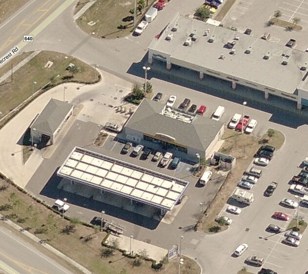
16781 Fishhawk Blvd, Lithia, FL 33547

Property Detail
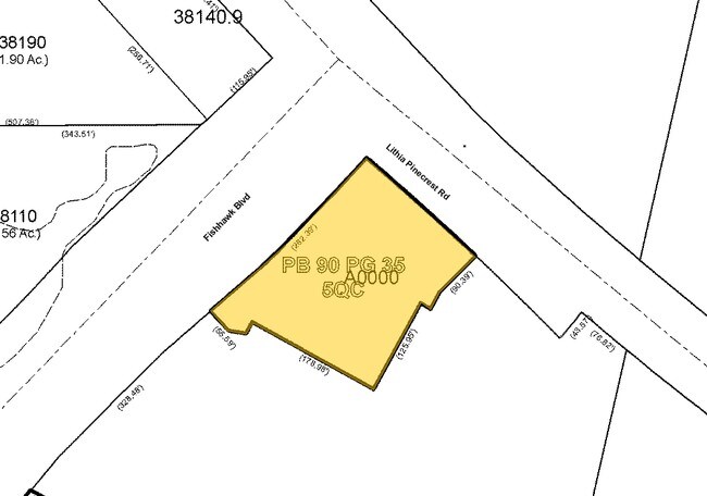
16781 Fishhawk Blvd
U-22-30-21-5QC-000000-A0000.0
FISHHAWK RANCH COMMERCIAL LOT A LOT A
Servicestationmarket
Hillsborough
PD
Florida
B and X Area of moderate flood hazard, usually the area between the limits of the 100-year and 500-year floods.
a
2024
1.10 AC
2025
Eastern Outlying
013922
Tampa/St Petersburg
5,012 SF
Tampa-St. Petersburg-Clearwater, FL
NEARBY LISTINGS FOR SALE OR LEASE
DEMOGRAPHICS near 16781 Fishhawk Blvd
1 mile
3 mile
5 mile
2025 Total Population
2,891
34,342
83,844
2030 Population
3,100
36,675
90,013
Pop Growth 2025-2030
+ 7.23%
+ 6.79%
+ 7.36%
Average Age
37
38
40
2025 Total Households
887
10,798
27,530
HH Growth 2025-2030
+ 7.33%
+ 6.92%
+ 7.50%
Median Household Inc
$154,738
$130,548
$120,342
Avg Household Size
3.20
3.10
3.00
2025 Avg HH Vehicles
2.00
2.00
2.00
Median Home Value
$667,590
$554,336
$469,138
Median Year Built
2007
2003
1999
Nearby Places
Map Layers
Map Styles
 Street
 Aerial
Layers
 Traffic
 Biking
Places
Listings with unknown addresses are not visible on the map
- Restaurants
- Banks
- Shops
- Fitness
- Groceries
PUBLIC TRANSPORTATION
AIRPORT
Tampa International
Drive
Walk
Distance
Tampa International
44 min
27.8 mi
St Pete-Clearwater International
Drive
Walk
Distance
St Pete-Clearwater International
62 min
37.1 mi
Freight Ports
Port of Tampa Bay
Drive
Walk
Distance
Port of Tampa Bay
32 min
17.9 mi
Nearby Properties
Address
Land Use
TOTAL SIZE
Lot Size
Zoning
Address
Land Use
TOTAL SIZE
Lot Size
Zoning
421,873 SF
93.26 AC
PD
Address
Land Use
TOTAL SIZE
Lot Size
Zoning
293,939 SF
86.31 AC
AS-1
Address
Land Use
TOTAL SIZE
Lot Size
Zoning
25,210 SF
66.38 AC
AR
Address
Land Use
TOTAL SIZE
Lot Size
Zoning
233.81 AC
AR
Address
Land Use
TOTAL SIZE
Lot Size
Zoning
96,158 SF
11.98 AC
PD
Address
Land Use
TOTAL SIZE
Lot Size
Zoning
99,450 SF
13.65 AC
PD
Address
Land Use
TOTAL SIZE
Lot Size
Zoning
97,587 SF
24.06 AC
PD
Address
Land Use
TOTAL SIZE
Lot Size
Zoning
99,384 SF
14.72 AC
PD
Address
Land Use
TOTAL SIZE
Lot Size
Zoning
67,300 SF
10.03 AC
PD
Address
Land Use
TOTAL SIZE
Lot Size
Zoning
69,591 SF
38.33 AC
PD
Address
Land Use
TOTAL SIZE
Lot Size
Zoning
93,917 SF
31.45 AC
PD
Address
Land Use
TOTAL SIZE
Lot Size
Zoning
48,842 SF
6.18 AC
AS-1
Address
Land Use
TOTAL SIZE
Lot Size
Zoning
322.61 AC
AR
Address
Land Use
TOTAL SIZE
Lot Size
Zoning
60,362 SF
6.47 AC
PD
Address
Land Use
TOTAL SIZE
Lot Size
Zoning
297.24 AC
PD
Address
Land Use
TOTAL SIZE
Lot Size
Zoning
48,315 SF
3.11 AC
PD
Address
Land Use
TOTAL SIZE
Lot Size
Zoning
34,982 SF
4.11 AC
PD
Address
Land Use
TOTAL SIZE
Lot Size
Zoning
25,854 SF
170.94 AC
PD
Address
Land Use
TOTAL SIZE
Lot Size
Zoning
23,527 SF
16.67 AC
AS-1
Address
Land Use
TOTAL SIZE
Lot Size
Zoning
17,301 SF
3.72 AC
PD
Address
Land Use
TOTAL SIZE
Lot Size
Zoning
952 SF
240.77 AC
AS-1
Address
Land Use
TOTAL SIZE
Lot Size
Zoning
160.94 AC
AR
Address
Land Use
TOTAL SIZE
Lot Size
Zoning
35,136 SF
0.78 AC
PD
Address
Land Use
TOTAL SIZE
Lot Size
Zoning
199.20 AC
PD
Address
Land Use
TOTAL SIZE
Lot Size
Zoning
5,184 SF
68.07 AC
PD
Address
Land Use
TOTAL SIZE
Lot Size
Zoning
13,640 SF
1.79 AC
PD
Address
Land Use
TOTAL SIZE
Lot Size
Zoning
33,381 SF
197.92 AC
PD
Address
Land Use
TOTAL SIZE
Lot Size
Zoning
13,800 SF
3.55 AC
PD
Address
Land Use
TOTAL SIZE
Lot Size
Zoning
20,668 SF
18.34 AC
AR
Address
Land Use
TOTAL SIZE
Lot Size
Zoning
209.66 AC
AR
The World's #1 Commercial Real Estate Marketplace
Connect with us
© 2026 CoStar Group
The information above has been obtained from sources believed reliable. While we do not doubt its accuracy we have not verified it and make no guarantee, warranty or representation about it. It is your responsibility to independently confirm its accuracy and completeness. Any projections, opinions, assumptions, or estimates used are for example only and do not represent the current or future performance of the property. The value of this transaction to you depends on tax and other factors which should be evaluated by your tax, financial, and legal advisors. You and your advisors should conduct a careful, independent investigation of the property to determine to your satisfaction the suitability of the property for your needs.