Property Record
16789 Kenmore Rd, Kendall, NY 14476
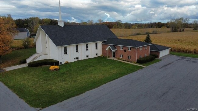


This Property Is For Sale
NEARBY LISTINGS FOR SALE OR LEASE
-
-
View all Kendall listings for sale on LoopNet.com
Property Detail
16789 Kenmore Rd
343000-032-000-0002-020-003
Orleans
Religious
New York
X
20.003
36073C0209D
7.90 AC
2025
Orleans County
2024
Rochester
401300
Rochester, NY
5,048 SF
DEMOGRAPHICS near 16789 Kenmore Rd
1 Mile
3 Mile
5 Mile
2024 Total Population
622
3,286
7,255
2029 Population
638
3,364
7,367
Pop Growth 2024-2029
+ 2.57%
+ 2.37%
+ 1.54%
Average Age
43
43
43
2024 Total Households
239
1,282
2,897
HH Growth 2024-2029
+ 2.51%
+ 2.26%
+ 1.45%
Median Household Inc
$89,508
$86,583
$77,454
Avg Household Size
2.60
2.50
2.50
2024 Avg HH Vehicles
2.00
2.00
2.00
Median Home Value
$187,332
$176,707
$162,166
Median Year Built
1969
1972
1974
Nearby Places
Map Layers
Map Styles
 Street
 Aerial
- Restaurants
- Banks
- Shops
- Fitness
- Groceries
PUBLIC TRANSPORTATION
AIRPORT
Frederick Douglass/Greater Rochester International
DRIVE
WALK
Distance
Frederick Douglass/Greater Rochester International
45 min
31.1 mi
Nearby Properties
Address
Land Use
TOTAL SIZE
Lot Size
Zoning
Address
Land Use
TOTAL SIZE
Lot Size
Zoning
78,521 SF
28.70 AC
02 - SINGL
Address
Land Use
TOTAL SIZE
Lot Size
Zoning
48,679 SF
20.50 AC
07 - MIXED
Address
Land Use
TOTAL SIZE
Lot Size
Zoning
Address
Land Use
TOTAL SIZE
Lot Size
Zoning
30,492 SF
16.10 AC
06 - INDUS
Address
Land Use
TOTAL SIZE
Lot Size
Zoning
9,360 SF
12.20 AC
03 - MULTI
Address
Land Use
TOTAL SIZE
Lot Size
Zoning
176.30 AC
RVL
Address
Land Use
TOTAL SIZE
Lot Size
Zoning
166.50 AC
RVL
Address
Land Use
TOTAL SIZE
Lot Size
Zoning
840 SF
69.90 AC
RVL
Address
Land Use
TOTAL SIZE
Lot Size
Zoning
128.90 AC
RVL
Address
Land Use
TOTAL SIZE
Lot Size
Zoning
9,100 SF
1.88 AC
03 - MULTI
Address
Land Use
TOTAL SIZE
Lot Size
Zoning
120.33 AC
RVL
Address
Land Use
TOTAL SIZE
Lot Size
Zoning
175.40 AC
06 - INDUS
Address
Land Use
TOTAL SIZE
Lot Size
Zoning
4,591 SF
0.97 AC
CGB
Address
Land Use
TOTAL SIZE
Lot Size
Zoning
102.60 AC
RVL
Address
Land Use
TOTAL SIZE
Lot Size
Zoning
105.30 AC
RVL
Address
Land Use
TOTAL SIZE
Lot Size
Zoning
4,272 SF
1.04 AC
RL
Address
Land Use
TOTAL SIZE
Lot Size
Zoning
109.30 AC
RVL
Address
Land Use
TOTAL SIZE
Lot Size
Zoning
92.24 AC
RVL
Address
Land Use
TOTAL SIZE
Lot Size
Zoning
91.25 AC
RVL
Address
Land Use
TOTAL SIZE
Lot Size
Zoning
10,000 SF
40 AC
02 - SINGL
Address
Land Use
TOTAL SIZE
Lot Size
Zoning
113.30 AC
07 - MIXED
Address
Land Use
TOTAL SIZE
Lot Size
Zoning
84.20 AC
RL
Address
Land Use
TOTAL SIZE
Lot Size
Zoning
97.60 AC
07 - MIXED
Address
Land Use
TOTAL SIZE
Lot Size
Zoning
Address
Land Use
TOTAL SIZE
Lot Size
Zoning
101.20 AC
07 - MIXED
Address
Land Use
TOTAL SIZE
Lot Size
Zoning
98 AC
07 - MIXED
Address
Land Use
TOTAL SIZE
Lot Size
Zoning
7,944 SF
3.10 AC
04 - FARM
Address
Land Use
TOTAL SIZE
Lot Size
Zoning
5,900 SF
0.47 AC
07 - MIXED
Address
Land Use
TOTAL SIZE
Lot Size
Zoning
88.40 AC
07 - MIXED
The World's #1 Commercial Real Estate Marketplace
Connect with us
© 2026 CoStar Group
The information above has been obtained from sources believed reliable. While we do not doubt its accuracy we have not verified it and make no guarantee, warranty or representation about it. It is your responsibility to independently confirm its accuracy and completeness. Any projections, opinions, assumptions, or estimates used are for example only and do not represent the current or future performance of the property. The value of this transaction to you depends on tax and other factors which should be evaluated by your tax, financial, and legal advisors. You and your advisors should conduct a careful, independent investigation of the property to determine to your satisfaction the suitability of the property for your needs.