Property Record
1679 Steel Way, Mount Joy, PA 17552

NEARBY LISTINGS FOR SALE OR LEASE
-
-
View all Mount Joy listings for sale on LoopNet.com
Property Detail
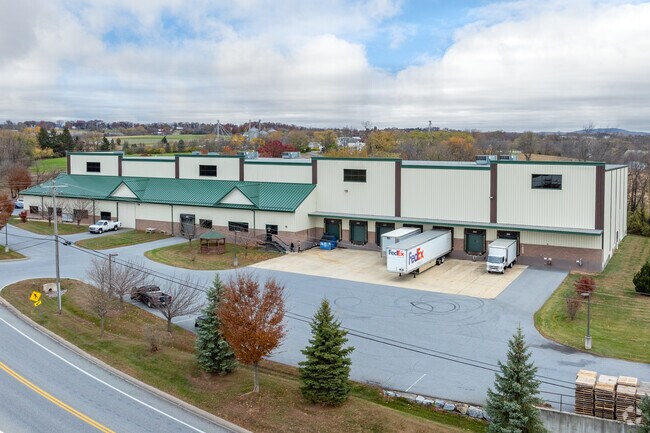
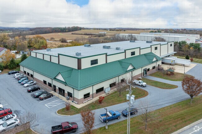
1679 Steel Way
Lancaster, PA
Greiner Industries Inc
461-39483-0-0000
1679 STEEL WAY DR
Lightindustrial
Lancaster
X
Pennsylvania
42071C0118F
2
2024
3.93 AC
2025
Lancaster County
010602
Philadelphia
47,270 SF
DEMOGRAPHICS near 1679 Steel Way
1 Mile
3 Mile
5 Mile
2024 Total Population
2,340
23,905
49,875
2029 Population
2,387
24,197
50,451
Pop Growth 2024-2029
+ 2.01%
+ 1.22%
+ 1.15%
Average Age
39
39
42
2024 Total Households
910
9,048
19,719
HH Growth 2024-2029
+ 1.98%
+ 1.34%
+ 1.26%
Median Household Inc
$96,215
$78,795
$76,957
Avg Household Size
2.50
2.50
2.40
2024 Avg HH Vehicles
2.00
2.00
2.00
Median Home Value
$283,533
$243,849
$251,592
Median Year Built
1996
1981
1985
Nearby Places
Map Layers
Map Styles
 Street
 Aerial
- Restaurants
- Banks
- Shops
- Fitness
- Groceries
PUBLIC TRANSPORTATION
COMMUTER RAIL
Elizabethtown Amtrak Station (Keystone Service - Amtrak, Pennsylvanian - Amtrak)
DRIVE
WALK
Distance
Elizabethtown Amtrak Station (Keystone Service - Amtrak, Pennsylvanian - Amtrak)
9 min
4.5 mi
Mount Joy Amtrak (Keystone Service - Amtrak)
DRIVE
WALK
Distance
Mount Joy Amtrak (Keystone Service - Amtrak)
9 min
4.9 mi
AIRPORT
Harrisburg International
DRIVE
WALK
Distance
Harrisburg International
22 min
16.3 mi
Freight Ports
Port of Baltimore
DRIVE
WALK
Distance
Port of Baltimore
113 min
78.2 mi
Nearby Properties
Address
Land Use
TOTAL SIZE
Lot Size
Zoning
Address
Land Use
TOTAL SIZE
Lot Size
Zoning
463,991 SF
89.23 AC
Address
Land Use
TOTAL SIZE
Lot Size
Zoning
154,112 SF
18.92 AC
Address
Land Use
TOTAL SIZE
Lot Size
Zoning
200,892 SF
16.25 AC
R3
Address
Land Use
TOTAL SIZE
Lot Size
Zoning
441,646 SF
59.55 AC
I-2
Address
Land Use
TOTAL SIZE
Lot Size
Zoning
138,828 SF
17.09 AC
Address
Land Use
TOTAL SIZE
Lot Size
Zoning
120,757 SF
3 AC
TN
Address
Land Use
TOTAL SIZE
Lot Size
Zoning
495,816 SF
26.02 AC
I-G
Address
Land Use
TOTAL SIZE
Lot Size
Zoning
4,160 SF
101.10 AC
A
Address
Land Use
TOTAL SIZE
Lot Size
Zoning
37,911 SF
14.40 AC
RT
Address
Land Use
TOTAL SIZE
Lot Size
Zoning
41,069 SF
3.12 AC
R1
Address
Land Use
TOTAL SIZE
Lot Size
Zoning
61,504 SF
6.64 AC
Address
Land Use
TOTAL SIZE
Lot Size
Zoning
71,425 SF
1 AC
TN
Address
Land Use
TOTAL SIZE
Lot Size
Zoning
71,326 SF
1 AC
TN
Address
Land Use
TOTAL SIZE
Lot Size
Zoning
44,610 SF
10.58 AC
R-2
Address
Land Use
TOTAL SIZE
Lot Size
Zoning
160,545 SF
9.54 AC
C-G
Address
Land Use
TOTAL SIZE
Lot Size
Zoning
Address
Land Use
TOTAL SIZE
Lot Size
Zoning
50,140 SF
0.73 AC
CBD
Address
Land Use
TOTAL SIZE
Lot Size
Zoning
47,082 SF
5.30 AC
Address
Land Use
TOTAL SIZE
Lot Size
Zoning
24,282 SF
4.35 AC
INS
Address
Land Use
TOTAL SIZE
Lot Size
Zoning
40,468 SF
4.08 AC
Address
Land Use
TOTAL SIZE
Lot Size
Zoning
44,696 SF
4.79 AC
R-3
Address
Land Use
TOTAL SIZE
Lot Size
Zoning
23,763 SF
13 AC
Address
Land Use
TOTAL SIZE
Lot Size
Zoning
59,277 SF
6.70 AC
C
Address
Land Use
TOTAL SIZE
Lot Size
Zoning
26,440 SF
1.10 AC
R3
Address
Land Use
TOTAL SIZE
Lot Size
Zoning
59,493 SF
0.87 AC
MU
Address
Land Use
TOTAL SIZE
Lot Size
Zoning
108,080 SF
9.31 AC
C-OI
Address
Land Use
TOTAL SIZE
Lot Size
Zoning
75,570 SF
8 AC
I-2
Address
Land Use
TOTAL SIZE
Lot Size
Zoning
25,730 SF
7.74 AC
C-2
Address
Land Use
TOTAL SIZE
Lot Size
Zoning
72,014 SF
21.90 AC
C
Address
Land Use
TOTAL SIZE
Lot Size
Zoning
56,580 SF
4.30 AC
MHDR
The World's #1 Commercial Real Estate Marketplace
Connect with us
© 2026 CoStar Group
The information above has been obtained from sources believed reliable. While we do not doubt its accuracy we have not verified it and make no guarantee, warranty or representation about it. It is your responsibility to independently confirm its accuracy and completeness. Any projections, opinions, assumptions, or estimates used are for example only and do not represent the current or future performance of the property. The value of this transaction to you depends on tax and other factors which should be evaluated by your tax, financial, and legal advisors. You and your advisors should conduct a careful, independent investigation of the property to determine to your satisfaction the suitability of the property for your needs.