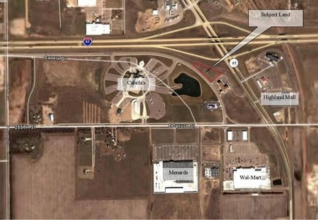
Property Record
168 S Harmon Dr, Mitchell, SD 57301

Property Detail
168 S Harmon Dr
Mitchell, SD
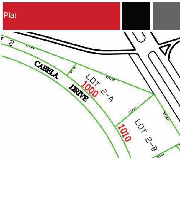
LT 2A OF CABELA'S FIRST ADDN-SE
15082-00000-002-10
DAVISON
Commercialnec
South Dakota
B and X Area of moderate flood hazard, usually the area between the limits of the 100-year and 500-year floods.
2a
0
1.70 AC
2025
South Dakota Area
962700
Other Market Areas
NEARBY LISTINGS FOR SALE OR LEASE
DEMOGRAPHICS near 168 S Harmon Dr
1 mile
3 mile
5 mile
2025 Total Population
1,380
14,848
17,567
2030 Population
1,387
14,878
17,604
Pop Growth 2025-2030
+ 0.51%
+ 0.20%
+ 0.21%
Average Age
39
40
41
2025 Total Households
603
6,540
7,605
HH Growth 2025-2030
+ 0.33%
+ 0.21%
+ 0.22%
Median Household Inc
$56,083
$57,404
$59,561
Avg Household Size
2.20
2.10
2.20
2025 Avg HH Vehicles
2.00
2.00
2.00
Median Home Value
$93,349
$174,964
$192,352
Median Year Built
1972
1966
1970
Nearby Places
Map Layers
Map Styles
 Street
 Aerial
Transit
 Traffic
 Biking
Places
Listings with unknown addresses are not visible on the map
- Restaurants
- Banks
- Shops
- Fitness
- Groceries
Nearby Properties
Address
Land Use
TOTAL SIZE
Lot Size
Zoning
Address
Land Use
TOTAL SIZE
Lot Size
Zoning
78,565 SF
2.46 AC
121310
Address
Land Use
TOTAL SIZE
Lot Size
Zoning
77,139 SF
24.21 AC
32213
Address
Land Use
TOTAL SIZE
Lot Size
Zoning
106,098 SF
8.56 AC
120211
Address
Land Use
TOTAL SIZE
Lot Size
Zoning
256,818 SF
26.78 AC
32213
Address
Land Use
TOTAL SIZE
Lot Size
Zoning
58,098 SF
3.19 AC
Address
Land Use
TOTAL SIZE
Lot Size
Zoning
173,161 SF
37 AC
12711
Address
Land Use
TOTAL SIZE
Lot Size
Zoning
80,578 SF
11.61 AC
20811
Address
Land Use
TOTAL SIZE
Lot Size
Zoning
189,974 SF
23.26 AC
12811
Address
Land Use
TOTAL SIZE
Lot Size
Zoning
82,368 SF
3.97 AC
22412
Address
Land Use
TOTAL SIZE
Lot Size
Zoning
68,640 SF
4.70 AC
82710
Address
Land Use
TOTAL SIZE
Lot Size
Zoning
75,800 SF
5.25 AC
21411
Address
Land Use
TOTAL SIZE
Lot Size
Zoning
54,617 SF
3.62 AC
21411
Address
Land Use
TOTAL SIZE
Lot Size
Zoning
77,272 SF
5.96 AC
Address
Land Use
TOTAL SIZE
Lot Size
Zoning
71,508 SF
6.31 AC
41212
Address
Land Use
TOTAL SIZE
Lot Size
Zoning
51,376 SF
5 AC
13111
Address
Land Use
TOTAL SIZE
Lot Size
Zoning
51,639 SF
7.24 AC
110711
Address
Land Use
TOTAL SIZE
Lot Size
Zoning
52,500 SF
6.93 AC
Address
Land Use
TOTAL SIZE
Lot Size
Zoning
151,044 SF
10.16 AC
32513
Address
Land Use
TOTAL SIZE
Lot Size
Zoning
1,898 SF
1.69 AC
21511
Address
Land Use
TOTAL SIZE
Lot Size
Zoning
26,044 SF
3.45 AC
92710
Address
Land Use
TOTAL SIZE
Lot Size
Zoning
2.31 AC
Address
Land Use
TOTAL SIZE
Lot Size
Zoning
55,296 SF
3.57 AC
101810
Address
Land Use
TOTAL SIZE
Lot Size
Zoning
Address
Land Use
TOTAL SIZE
Lot Size
Zoning
17,717 SF
0.82 AC
12611
Address
Land Use
TOTAL SIZE
Lot Size
Zoning
3,680 SF
52.47 AC
51810
Address
Land Use
TOTAL SIZE
Lot Size
Zoning
17,931 SF
3.18 AC
12611
Address
Land Use
TOTAL SIZE
Lot Size
Zoning
8.22 AC
Address
Land Use
TOTAL SIZE
Lot Size
Zoning
26,964 SF
1.36 AC
72610
Address
Land Use
TOTAL SIZE
Lot Size
Zoning
28,556 SF
1.78 AC
82010
Address
Land Use
TOTAL SIZE
Lot Size
Zoning
17,918 SF
2.45 AC
91410
The World's #1 Commercial Real Estate Marketplace
Connect with us
© 2026 CoStar Group
The information above has been obtained from sources believed reliable. While we do not doubt its accuracy we have not verified it and make no guarantee, warranty or representation about it. It is your responsibility to independently confirm its accuracy and completeness. Any projections, opinions, assumptions, or estimates used are for example only and do not represent the current or future performance of the property. The value of this transaction to you depends on tax and other factors which should be evaluated by your tax, financial, and legal advisors. You and your advisors should conduct a careful, independent investigation of the property to determine to your satisfaction the suitability of the property for your needs.