Property Record
168 Willie Paulk Pkwy, Dublin, GA 31021

Save to a Folder
{{folder.Name}}
{{folder.ListingIds.length}} Properties
{{folder.ListingIds.length}} Property
Create a New Folder
Property Detail
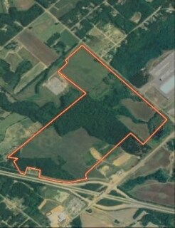
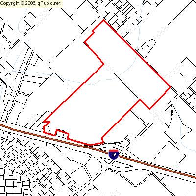
168 Willie Paulk Pkwy
101-012-D
VALMIERA GLASS
Officebuilding
LAURENS
UNZONED RU
Georgia
B and X Area of moderate flood hazard, usually the area between the limits of the 100-year and 500-year floods.
40 AC
2025
Georgia South Area
2025
Other Market Areas
950500
Dublin, GA
11,126 SF
NEARBY LISTINGS FOR SALE OR LEASE
-
-
View all Dublin listings for sale on LoopNet.com
DEMOGRAPHICS near 168 Willie Paulk Pkwy
1 mile
3 mile
5 mile
2025 Total Population
441
3,735
18,692
2030 Population
448
3,796
18,894
Pop Growth 2025-2030
+ 1.59%
+ 1.63%
+ 1.08%
Average Age
43
43
41
2025 Total Households
168
1,419
7,452
HH Growth 2025-2030
+ 1.19%
+ 1.55%
+ 0.93%
Median Household Inc
$49,999
$49,120
$45,957
Avg Household Size
2.50
2.50
2.40
2025 Avg HH Vehicles
2.00
2.00
2.00
Median Home Value
$168,420
$158,241
$199,164
Median Year Built
1989
1987
1980
Nearby Places
Map Layers
Map Styles
 Street
 Aerial
Layers
 Traffic
 Biking
Places
Listings with unknown addresses are not visible on the map
- Restaurants
- Banks
- Shops
- Fitness
- Groceries
Nearby Properties
Address
Land Use
TOTAL SIZE
Lot Size
Zoning
Address
Land Use
TOTAL SIZE
Lot Size
Zoning
448 SF
95 AC
COMMERCIAL
Address
Land Use
TOTAL SIZE
Lot Size
Zoning
598,082 SF
133.35 AC
INDUSTRIAL
Address
Land Use
TOTAL SIZE
Lot Size
Zoning
217,773 SF
48.62 AC
RESIDENTIA
Address
Land Use
TOTAL SIZE
Lot Size
Zoning
311,911 SF
53.17 AC
UNZONED RU
Address
Land Use
TOTAL SIZE
Lot Size
Zoning
484,158 SF
116.80 AC
INDUSTRIAL
Address
Land Use
TOTAL SIZE
Lot Size
Zoning
60,816 SF
2.03 AC
COMMERCIAL
Address
Land Use
TOTAL SIZE
Lot Size
Zoning
269,114 SF
43.42 AC
INDUSTRIAL
Address
Land Use
TOTAL SIZE
Lot Size
Zoning
28,160 SF
28.64 AC
INDUSTRIAL
Address
Land Use
TOTAL SIZE
Lot Size
Zoning
299,250 SF
26.72 AC
INDUSTRIAL
Address
Land Use
TOTAL SIZE
Lot Size
Zoning
47,421 SF
1.57 AC
COMMERCIAL
Address
Land Use
TOTAL SIZE
Lot Size
Zoning
7,768 SF
59.47 AC
COMMERCIAL
Address
Land Use
TOTAL SIZE
Lot Size
Zoning
45,036 SF
2.10 AC
UNZONED SU
Address
Land Use
TOTAL SIZE
Lot Size
Zoning
38,079 SF
1.20 AC
COMMERCIAL
Address
Land Use
TOTAL SIZE
Lot Size
Zoning
49,962 SF
3.07 AC
COMMERCIAL
Address
Land Use
TOTAL SIZE
Lot Size
Zoning
388,955 SF
39.01 AC
INDUSTRIAL
Address
Land Use
TOTAL SIZE
Lot Size
Zoning
173,468 SF
18.75 AC
RESIDENTIA
Address
Land Use
TOTAL SIZE
Lot Size
Zoning
8,058 SF
16.30 AC
RESIDENTIA
Address
Land Use
TOTAL SIZE
Lot Size
Zoning
78,501 SF
18.52 AC
UNZONED SU
Address
Land Use
TOTAL SIZE
Lot Size
Zoning
80,000 SF
25.50 AC
INDUSTRIAL
Address
Land Use
TOTAL SIZE
Lot Size
Zoning
40,944 SF
4.60 AC
COMMERCIAL
Address
Land Use
TOTAL SIZE
Lot Size
Zoning
60,000 SF
22.44 AC
COMMERCIAL
Address
Land Use
TOTAL SIZE
Lot Size
Zoning
37,136 SF
4.92 AC
COMMERCIAL
Address
Land Use
TOTAL SIZE
Lot Size
Zoning
70,680 SF
22.72 AC
RESIDENTIA
Address
Land Use
TOTAL SIZE
Lot Size
Zoning
8,613 SF
5.05 AC
COMMERCIAL
Address
Land Use
TOTAL SIZE
Lot Size
Zoning
30,232 SF
4.09 AC
COMMERCIAL
Address
Land Use
TOTAL SIZE
Lot Size
Zoning
35,120 SF
10.06 AC
UNZONED RU
Address
Land Use
TOTAL SIZE
Lot Size
Zoning
73,260 SF
7.50 AC
INDUSTRIAL
Address
Land Use
TOTAL SIZE
Lot Size
Zoning
19,880 SF
8.65 AC
COMMERCIAL
Address
Land Use
TOTAL SIZE
Lot Size
Zoning
8,263 SF
6.42 AC
B-2
The World's #1 Commercial Real Estate Marketplace
Connect with us
© 2026 CoStar Group
The information above has been obtained from sources believed reliable. While we do not doubt its accuracy we have not verified it and make no guarantee, warranty or representation about it. It is your responsibility to independently confirm its accuracy and completeness. Any projections, opinions, assumptions, or estimates used are for example only and do not represent the current or future performance of the property. The value of this transaction to you depends on tax and other factors which should be evaluated by your tax, financial, and legal advisors. You and your advisors should conduct a careful, independent investigation of the property to determine to your satisfaction the suitability of the property for your needs.