Property Record
1680 Nc Hwy 5, , NC
NEARBY LISTINGS FOR SALE OR LEASE
-
-
View all listings for lease on LoopNet.com
Property Detail
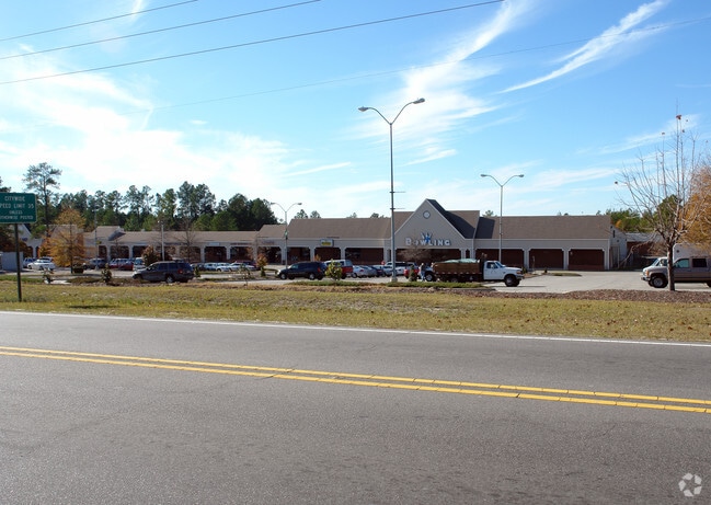
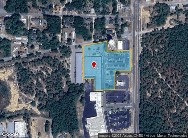
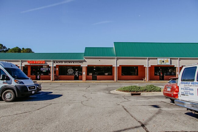
1680 Nc Hwy 5
8551-00-85-7390
SHOPPING CENTER PH II
Stripcommercialcenter
Moore
X
North Carolina
3710854000J
4.22 AC
2024
North Carolina Southeast Area
2024
Other Market Areas
950702
Pinehurst-Southern Pines, NC
7,800 SF
DEMOGRAPHICS near 1680 Nc Hwy 5
1 Mile
3 Mile
5 Mile
2024 Total Population
1,976
18,816
48,734
2029 Population
2,285
21,800
56,401
Pop Growth 2024-2029
+ 15.64%
+ 15.86%
+ 15.73%
Average Age
48
48
45
2024 Total Households
898
8,365
21,690
HH Growth 2024-2029
+ 15.81%
+ 16.22%
+ 16.01%
Median Household Inc
$71,785
$89,110
$71,338
Avg Household Size
2.20
2.20
2.20
2024 Avg HH Vehicles
2.00
2.00
2.00
Median Home Value
$353,240
$401,668
$356,676
Median Year Built
1987
1993
1995
Nearby Places
Map Layers
Map Styles
 Street
 Aerial
- Restaurants
- Banks
- Shops
- Fitness
- Groceries
PUBLIC TRANSPORTATION
COMMUTER RAIL
DRIVE
WALK
Distance
14 min
8.0 mi
AIRPORT
Fayetteville Regional/Grannis Field
DRIVE
WALK
Distance
Fayetteville Regional/Grannis Field
67 min
42.4 mi
SALE & LEASE HISTORY
LISTING DATE
SALE/LEASE

Nov 04, 2023
For Lease
Nearby Properties
Address
Land Use
TOTAL SIZE
Lot Size
Zoning
Address
Land Use
TOTAL SIZE
Lot Size
Zoning
3,953 SF
86.18 AC
MULTI
Address
Land Use
TOTAL SIZE
Lot Size
Zoning
29,476 SF
22.76 AC
H
Address
Land Use
TOTAL SIZE
Lot Size
Zoning
20,091 SF
12 AC
PPC
Address
Land Use
TOTAL SIZE
Lot Size
Zoning
16.26 AC
PD
Address
Land Use
TOTAL SIZE
Lot Size
Zoning
7,161 SF
0.87 AC
RD
Address
Land Use
TOTAL SIZE
Lot Size
Zoning
17,091 SF
12.65 AC
R10
Address
Land Use
TOTAL SIZE
Lot Size
Zoning
21,138 SF
473.33 AC
RD
Address
Land Use
TOTAL SIZE
Lot Size
Zoning
70,130 SF
19.18 AC
Address
Land Use
TOTAL SIZE
Lot Size
Zoning
51,552 SF
33.02 AC
GBCD
Address
Land Use
TOTAL SIZE
Lot Size
Zoning
83,896 SF
66.98 AC
R20
Address
Land Use
TOTAL SIZE
Lot Size
Zoning
4,992 SF
14.75 AC
PD
Address
Land Use
TOTAL SIZE
Lot Size
Zoning
11.80 AC
Address
Land Use
TOTAL SIZE
Lot Size
Zoning
190.53 AC
Address
Land Use
TOTAL SIZE
Lot Size
Zoning
155.66 AC
RD
Address
Land Use
TOTAL SIZE
Lot Size
Zoning
7.45 AC
Address
Land Use
TOTAL SIZE
Lot Size
Zoning
199,100 SF
24.89 AC
HC
Address
Land Use
TOTAL SIZE
Lot Size
Zoning
2,450 SF
2.96 AC
Address
Land Use
TOTAL SIZE
Lot Size
Zoning
25,651 SF
4.34 AC
CM
Address
Land Use
TOTAL SIZE
Lot Size
Zoning
57,109 SF
4.08 AC
GBSD
Address
Land Use
TOTAL SIZE
Lot Size
Zoning
0.84 AC
GC
Address
Land Use
TOTAL SIZE
Lot Size
Zoning
20,709 SF
3.60 AC
H
Address
Land Use
TOTAL SIZE
Lot Size
Zoning
33,886 SF
9.68 AC
R10
Address
Land Use
TOTAL SIZE
Lot Size
Zoning
0.87 AC
Address
Land Use
TOTAL SIZE
Lot Size
Zoning
0.87 AC
Address
Land Use
TOTAL SIZE
Lot Size
Zoning
47,273 SF
11.25 AC
NC
Address
Land Use
TOTAL SIZE
Lot Size
Zoning
23,472 SF
3.49 AC
GC
Address
Land Use
TOTAL SIZE
Lot Size
Zoning
7.43 AC
Address
Land Use
TOTAL SIZE
Lot Size
Zoning
1,034 SF
12.10 AC
RM1
Address
Land Use
TOTAL SIZE
Lot Size
Zoning
5,090 SF
99.55 AC
RD
Address
Land Use
TOTAL SIZE
Lot Size
Zoning
5,700 SF
205.35 AC
RS2CD
The World's #1 Commercial Real Estate Marketplace
Connect with us
© 2025 CoStar Group
The information above has been obtained from sources believed reliable. While we do not doubt its accuracy we have not verified it and make no guarantee, warranty or representation about it. It is your responsibility to independently confirm its accuracy and completeness. Any projections, opinions, assumptions, or estimates used are for example only and do not represent the current or future performance of the property. The value of this transaction to you depends on tax and other factors which should be evaluated by your tax, financial, and legal advisors. You and your advisors should conduct a careful, independent investigation of the property to determine to your satisfaction the suitability of the property for your needs.