Property Record
1680 State Route 23, Wayne, NJ 07470
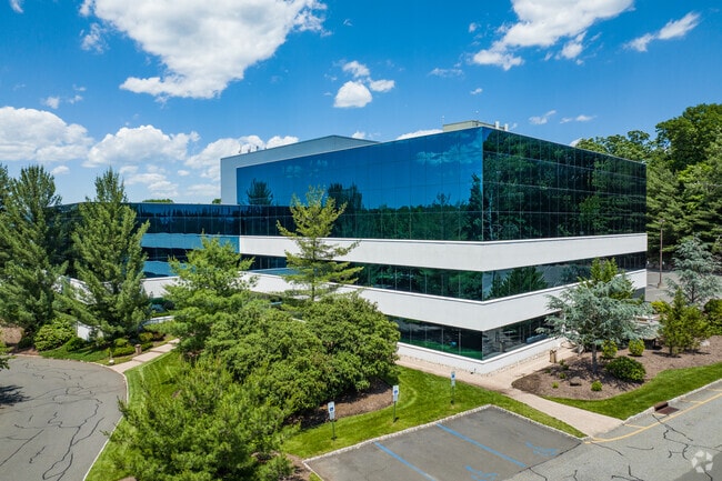

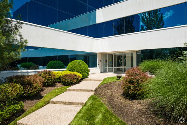

Property Detail
1680 State Route 23
14-01602-0000-00004
Passaic
Officebuilding
New Jersey
SB
4
B and X Area of moderate flood hazard, usually the area between the limits of the 100-year and 500-year floods.
4.37 AC
2024
Passaic Rt 46/23
2025
Northern New Jersey
246202
New York-Jersey City-White Plains, NY-NJ
75,286 SF
NEARBY LISTINGS FOR SALE OR LEASE
DEMOGRAPHICS near 1680 State Route 23
1 mile
3 mile
5 mile
2025 Total Population
8,138
69,764
200,248
2030 Population
8,445
72,110
205,847
Pop Growth 2025-2030
+ 3.77%
+ 3.36%
+ 2.80%
Average Age
42
43
42
2025 Total Households
2,658
25,208
69,775
HH Growth 2025-2030
+ 3.61%
+ 3.18%
+ 2.82%
Median Household Inc
$162,049
$135,220
$116,060
Avg Household Size
3.00
2.70
2.80
2025 Avg HH Vehicles
2.00
2.00
2.00
Median Home Value
$653,544
$629,833
$577,353
Median Year Built
1958
1965
1964
Nearby Places
Map Layers
Map Styles
 Street
 Aerial
Transit
 Traffic
 Biking
Places
Listings with unknown addresses are not visible on the map
- Restaurants
- Banks
- Shops
- Fitness
- Groceries
PUBLIC TRANSPORTATION
COMMUTER RAIL
Mountain View (Montclair-Boonton Line - NJ Transit Commuter Rail (NJ Transit))
Drive
Walk
Distance
Mountain View (Montclair-Boonton Line - NJ Transit Commuter Rail (NJ Transit))
7 min
3.8 mi
Lincoln Park (Montclair-Boonton Line - NJ Transit Commuter Rail (NJ Transit))
Drive
Walk
Distance
Lincoln Park (Montclair-Boonton Line - NJ Transit Commuter Rail (NJ Transit))
9 min
4.0 mi
AIRPORT
Newark Liberty International
Drive
Walk
Distance
Newark Liberty International
32 min
26.0 mi
LaGuardia
Drive
Walk
Distance
LaGuardia
48 min
34.0 mi
Westchester County
Drive
Walk
Distance
Westchester County
66 min
49.7 mi
Freight Ports
Maher Terminal
Drive
Walk
Distance
Maher Terminal
39 min
25.8 mi
SALE & LEASE HISTORY
LISTING DATE
SALE/LEASE

Sep 24, 2016
For Lease
Nov 06, 2020
For Lease
Nearby Properties
Address
Land Use
TOTAL SIZE
Lot Size
Zoning
Address
Land Use
TOTAL SIZE
Lot Size
Zoning
21.99 AC
H
Address
Land Use
TOTAL SIZE
Lot Size
Zoning
49,701 SF
29.34 AC
GAR
Address
Land Use
TOTAL SIZE
Lot Size
Zoning
18.76 AC
C-3
Address
Land Use
TOTAL SIZE
Lot Size
Zoning
960 SF
22.84 AC
GWS
Address
Land Use
TOTAL SIZE
Lot Size
Zoning
32.21 AC
R-15
Address
Land Use
TOTAL SIZE
Lot Size
Zoning
207,519 SF
32.39 AC
Address
Land Use
TOTAL SIZE
Lot Size
Zoning
5,880 SF
17.46 AC
I
Address
Land Use
TOTAL SIZE
Lot Size
Zoning
342,518 SF
31.80 AC
IP
Address
Land Use
TOTAL SIZE
Lot Size
Zoning
251,974 SF
27.96 AC
Address
Land Use
TOTAL SIZE
Lot Size
Zoning
334,755 SF
107.89 AC
Address
Land Use
TOTAL SIZE
Lot Size
Zoning
192,206 SF
7.73 AC
R-20
Address
Land Use
TOTAL SIZE
Lot Size
Zoning
41.71 AC
C-4
Address
Land Use
TOTAL SIZE
Lot Size
Zoning
97,631 SF
10.01 AC
B-2
Address
Land Use
TOTAL SIZE
Lot Size
Zoning
277,661 SF
50.20 AC
Address
Land Use
TOTAL SIZE
Lot Size
Zoning
148,000 SF
6.44 AC
Address
Land Use
TOTAL SIZE
Lot Size
Zoning
63,460 SF
10.72 AC
Address
Land Use
TOTAL SIZE
Lot Size
Zoning
259,919 SF
48.14 AC
Address
Land Use
TOTAL SIZE
Lot Size
Zoning
9.08 AC
H-C
Address
Land Use
TOTAL SIZE
Lot Size
Zoning
14.01 AC
Address
Land Use
TOTAL SIZE
Lot Size
Zoning
9.28 AC
R-11
Address
Land Use
TOTAL SIZE
Lot Size
Zoning
10.07 AC
R-15
Address
Land Use
TOTAL SIZE
Lot Size
Zoning
143,500 SF
14.73 AC
I
Address
Land Use
TOTAL SIZE
Lot Size
Zoning
17.30 AC
I3
Address
Land Use
TOTAL SIZE
Lot Size
Zoning
12.24 AC
H-C
Address
Land Use
TOTAL SIZE
Lot Size
Zoning
1,824 SF
243 AC
R-B
Address
Land Use
TOTAL SIZE
Lot Size
Zoning
7,398 SF
13.96 AC
Address
Land Use
TOTAL SIZE
Lot Size
Zoning
82,061 SF
12.39 AC
R-15
Address
Land Use
TOTAL SIZE
Lot Size
Zoning
1,600 SF
11.60 AC
OB
Address
Land Use
TOTAL SIZE
Lot Size
Zoning
1,197.68 AC
Address
Land Use
TOTAL SIZE
Lot Size
Zoning
634 SF
14.76 AC
H
The World's #1 Commercial Real Estate Marketplace
Connect with us
© 2026 CoStar Group
The information above has been obtained from sources believed reliable. While we do not doubt its accuracy we have not verified it and make no guarantee, warranty or representation about it. It is your responsibility to independently confirm its accuracy and completeness. Any projections, opinions, assumptions, or estimates used are for example only and do not represent the current or future performance of the property. The value of this transaction to you depends on tax and other factors which should be evaluated by your tax, financial, and legal advisors. You and your advisors should conduct a careful, independent investigation of the property to determine to your satisfaction the suitability of the property for your needs.