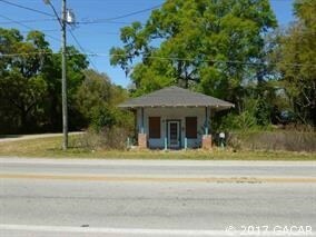
Property Record
16817 Nw State Road 45, High Springs, FL 32643

NEARBY LISTINGS FOR SALE OR LEASE
Property Detail
16817 Nw State Road 45
Gainesville, FL
Alachua
01484-004-000
Florida
Mobilemanufacturedhomeregardlessoflandownership
2.89 AC
X
Gainesville
12001C0115D
Other Market Areas
1,320 SF
DEMOGRAPHICS near 16817 Nw State Road 45
1 Mile
3 Mile
5 Mile
2024 Total Population
1,923
8,147
13,581
2029 Population
2,060
8,741
14,540
Pop Growth 2024-2029
+ 7.12%
+ 7.29%
+ 7.06%
Average Age
41
41
42
2024 Total Households
758
3,153
5,279
HH Growth 2024-2029
+ 7.26%
+ 7.42%
+ 7.27%
Median Household Inc
$79,575
$76,524
$74,750
Avg Household Size
2.50
2.60
2.60
2024 Avg HH Vehicles
2.00
2.00
2.00
Median Home Value
$199,179
$240,827
$237,872
Median Year Built
1994
1997
1997
Nearby Places
Map Layers
Map Styles
 Street
 Aerial
- Restaurants
- Banks
- Shops
- Fitness
- Groceries
PUBLIC TRANSPORTATION
AIRPORT
Gainesville Regional
DRIVE
WALK
Distance
Gainesville Regional
41 min
24.8 mi
Freight Ports
Jacksonville Port
DRIVE
WALK
Distance
Jacksonville Port
119 min
91.6 mi
SALE & LEASE HISTORY
LISTING DATE
SALE/LEASE

Aug 10, 2017
For Sale
Nearby Properties
Address
Land Use
TOTAL SIZE
Lot Size
Zoning
Address
Land Use
TOTAL SIZE
Lot Size
Zoning
245,766 SF
27.16 AC
R2
Address
Land Use
TOTAL SIZE
Lot Size
Zoning
76,591 SF
263.12 AC
R1
Address
Land Use
TOTAL SIZE
Lot Size
Zoning
64,348 SF
8.84 AC
C3
Address
Land Use
TOTAL SIZE
Lot Size
Zoning
34,579 SF
4.87 AC
C2
Address
Land Use
TOTAL SIZE
Lot Size
Zoning
56,855 SF
8.20 AC
C3
Address
Land Use
TOTAL SIZE
Lot Size
Zoning
44,540 SF
5.23 AC
C3
Address
Land Use
TOTAL SIZE
Lot Size
Zoning
50,757 SF
83.01 AC
R1
Address
Land Use
TOTAL SIZE
Lot Size
Zoning
36,092 SF
2.81 AC
R2
Address
Land Use
TOTAL SIZE
Lot Size
Zoning
9,369 SF
6.90 AC
C2
Address
Land Use
TOTAL SIZE
Lot Size
Zoning
110,796 SF
7.08 AC
I
Address
Land Use
TOTAL SIZE
Lot Size
Zoning
26,920 SF
1.95 AC
I
Address
Land Use
TOTAL SIZE
Lot Size
Zoning
21,499 SF
6 AC
C3
Address
Land Use
TOTAL SIZE
Lot Size
Zoning
Address
Land Use
TOTAL SIZE
Lot Size
Zoning
19,146 SF
2 AC
C1
Address
Land Use
TOTAL SIZE
Lot Size
Zoning
11,462 SF
0.80 AC
C2
Address
Land Use
TOTAL SIZE
Lot Size
Zoning
7,860 SF
126.96 AC
A
Address
Land Use
TOTAL SIZE
Lot Size
Zoning
12,076 SF
1.27 AC
C3
Address
Land Use
TOTAL SIZE
Lot Size
Zoning
47,116 SF
12.01 AC
I
Address
Land Use
TOTAL SIZE
Lot Size
Zoning
5,688 SF
237.81 AC
A
Address
Land Use
TOTAL SIZE
Lot Size
Zoning
22,016 SF
5.01 AC
C3
Address
Land Use
TOTAL SIZE
Lot Size
Zoning
23,171 SF
1.92 AC
C1
Address
Land Use
TOTAL SIZE
Lot Size
Zoning
11,200 SF
3.56 AC
I
Address
Land Use
TOTAL SIZE
Lot Size
Zoning
47,621 SF
4.72 AC
I
Address
Land Use
TOTAL SIZE
Lot Size
Zoning
14,263 SF
4.54 AC
C3
Address
Land Use
TOTAL SIZE
Lot Size
Zoning
9,659 SF
0.54 AC
C3
Address
Land Use
TOTAL SIZE
Lot Size
Zoning
13,600 SF
0.98 AC
I
Address
Land Use
TOTAL SIZE
Lot Size
Zoning
7,902 SF
0.34 AC
C2
Address
Land Use
TOTAL SIZE
Lot Size
Zoning
14,984 SF
1.76 AC
C3
Address
Land Use
TOTAL SIZE
Lot Size
Zoning
48,678 SF
4.24 AC
I
Address
Land Use
TOTAL SIZE
Lot Size
Zoning
6,634 SF
0.43 AC
C2
The World's #1 Commercial Real Estate Marketplace
Connect with us
© 2026 CoStar Group
The information above has been obtained from sources believed reliable. While we do not doubt its accuracy we have not verified it and make no guarantee, warranty or representation about it. It is your responsibility to independently confirm its accuracy and completeness. Any projections, opinions, assumptions, or estimates used are for example only and do not represent the current or future performance of the property. The value of this transaction to you depends on tax and other factors which should be evaluated by your tax, financial, and legal advisors. You and your advisors should conduct a careful, independent investigation of the property to determine to your satisfaction the suitability of the property for your needs.