Property Record
16828 Hayes St, Grand Haven, MI 49417
NEARBY LISTINGS FOR SALE OR LEASE
Property Detail
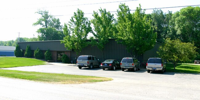
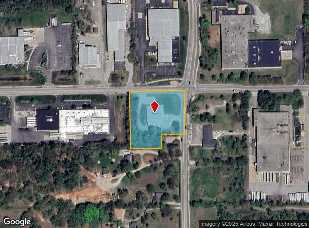
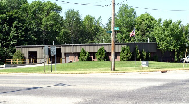
16828 Hayes St
70-07-04-200-055
PART OF NE 1/4 COM NE SEC COR, TH ALG N SEC LI N 89D 41M 38S W 308 FT, S 0D 18M 50S W 32868 FT, S 89D 41M 38S E TO A PT N 89D
Lightindustrial
Ottawa
X
Michigan
26121C0425E
1.68 AC
2024
Grand Haven/Ferrysburg
2025
West Michigan
021204
Grand Rapids-Wyoming, MI
8,100 SF
DEMOGRAPHICS near 16828 Hayes St
1 Mile
3 Mile
5 Mile
2024 Total Population
2,595
27,930
48,730
2029 Population
2,784
29,576
51,743
Pop Growth 2024-2029
+ 7.28%
+ 5.89%
+ 6.18%
Average Age
39
43
43
2024 Total Households
1,259
11,835
20,303
HH Growth 2024-2029
+ 7.55%
+ 6.08%
+ 6.33%
Median Household Inc
$60,872
$73,749
$75,107
Avg Household Size
2.10
2.30
2.40
2024 Avg HH Vehicles
2.00
2.00
2.00
Median Home Value
$297,169
$288,809
$295,568
Median Year Built
1999
1977
1982
Nearby Places
Map Layers
Map Styles
 Street
 Aerial
- Restaurants
- Banks
- Shops
- Fitness
- Groceries
PUBLIC TRANSPORTATION
AIRPORT
Gerald R Ford International
DRIVE
WALK
Distance
Gerald R Ford International
66 min
49.6 mi
Nearby Properties
Address
Land Use
TOTAL SIZE
Lot Size
Zoning
Address
Land Use
TOTAL SIZE
Lot Size
Zoning
199,740 SF
15 AC
PUD
Address
Land Use
TOTAL SIZE
Lot Size
Zoning
355,785 SF
24.60 AC
I-1
Address
Land Use
TOTAL SIZE
Lot Size
Zoning
188,314 SF
9.72 AC
Address
Land Use
TOTAL SIZE
Lot Size
Zoning
220,630 SF
10.34 AC
PUD
Address
Land Use
TOTAL SIZE
Lot Size
Zoning
184,312 SF
11.47 AC
PUD
Address
Land Use
TOTAL SIZE
Lot Size
Zoning
131,302 SF
4.70 AC
Address
Land Use
TOTAL SIZE
Lot Size
Zoning
60,299 SF
19 AC
OVERLAY
Address
Land Use
TOTAL SIZE
Lot Size
Zoning
191,144 SF
16.60 AC
Address
Land Use
TOTAL SIZE
Lot Size
Zoning
249,728 SF
15.06 AC
Address
Land Use
TOTAL SIZE
Lot Size
Zoning
121,189 SF
8.73 AC
PUD
Address
Land Use
TOTAL SIZE
Lot Size
Zoning
113,566 SF
6.70 AC
PUD
Address
Land Use
TOTAL SIZE
Lot Size
Zoning
192,641 SF
25.16 AC
Address
Land Use
TOTAL SIZE
Lot Size
Zoning
202,338 SF
8.95 AC
Address
Land Use
TOTAL SIZE
Lot Size
Zoning
191,989 SF
10.44 AC
Address
Land Use
TOTAL SIZE
Lot Size
Zoning
112,745 SF
10.56 AC
PUD
Address
Land Use
TOTAL SIZE
Lot Size
Zoning
53,682 SF
0.99 AC
Address
Land Use
TOTAL SIZE
Lot Size
Zoning
184,100 SF
9.74 AC
Address
Land Use
TOTAL SIZE
Lot Size
Zoning
90,701 SF
5.65 AC
Address
Land Use
TOTAL SIZE
Lot Size
Zoning
217,995 SF
40.96 AC
PUD
Address
Land Use
TOTAL SIZE
Lot Size
Zoning
146,163 SF
13.23 AC
Address
Land Use
TOTAL SIZE
Lot Size
Zoning
143,083 SF
12.25 AC
Address
Land Use
TOTAL SIZE
Lot Size
Zoning
148,413 SF
38.08 AC
Address
Land Use
TOTAL SIZE
Lot Size
Zoning
71.84 AC
R-4
Address
Land Use
TOTAL SIZE
Lot Size
Zoning
960 SF
22.46 AC
Address
Land Use
TOTAL SIZE
Lot Size
Zoning
146,285 SF
7.77 AC
Address
Land Use
TOTAL SIZE
Lot Size
Zoning
127,125 SF
11.63 AC
Address
Land Use
TOTAL SIZE
Lot Size
Zoning
98,248 SF
17.79 AC
I-1
Address
Land Use
TOTAL SIZE
Lot Size
Zoning
50,969 SF
1.67 AC
Address
Land Use
TOTAL SIZE
Lot Size
Zoning
16,762 SF
143.08 AC
R-1
Address
Land Use
TOTAL SIZE
Lot Size
Zoning
42,300 SF
3.12 AC
The World's #1 Commercial Real Estate Marketplace
Connect with us
© 2025 CoStar Group
The information above has been obtained from sources believed reliable. While we do not doubt its accuracy we have not verified it and make no guarantee, warranty or representation about it. It is your responsibility to independently confirm its accuracy and completeness. Any projections, opinions, assumptions, or estimates used are for example only and do not represent the current or future performance of the property. The value of this transaction to you depends on tax and other factors which should be evaluated by your tax, financial, and legal advisors. You and your advisors should conduct a careful, independent investigation of the property to determine to your satisfaction the suitability of the property for your needs.