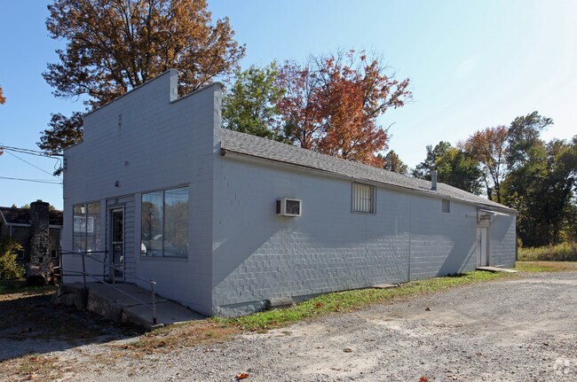
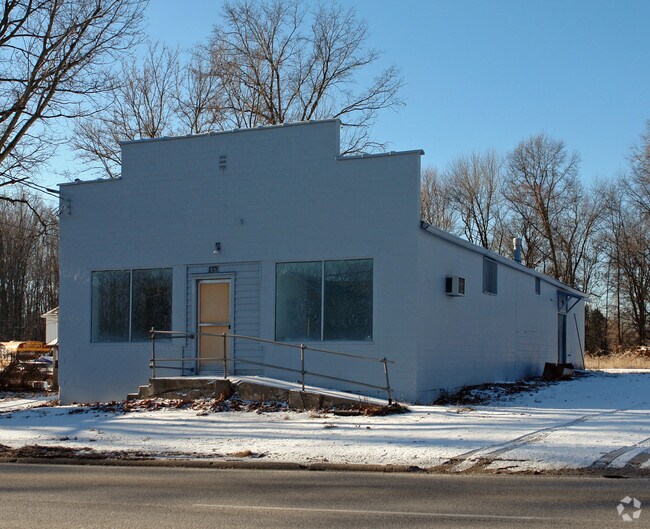
Property Record
1683 E Main St, Amelia, OH 45102

Property Detail
1683 E Main St
28-28-06C-201P
PENDING DELQ CO UTIL
Commercialnec
Clermont
B and X Area of moderate flood hazard, usually the area between the limits of the 100-year and 500-year floods.
Ohio
2025
1.41 AC
2025
Eastgate/Anderson Twp
041503
Cincinnati/Dayton
3,375 SF
Cincinnati, OH-KY-IN
NEARBY LISTINGS FOR SALE OR LEASE
-
-
View all Amelia listings for sale on LoopNet.com
DEMOGRAPHICS near 1683 E Main St
1 mile
3 mile
5 mile
2025 Total Population
7,412
28,900
57,675
2030 Population
7,708
29,855
59,582
Pop Growth 2025-2030
+ 3.99%
+ 3.30%
+ 3.31%
Average Age
37
40
40
2025 Total Households
2,802
10,958
22,892
HH Growth 2025-2030
+ 3.93%
+ 3.34%
+ 3.38%
Median Household Inc
$77,783
$80,731
$78,809
Avg Household Size
2.60
2.60
2.50
2025 Avg HH Vehicles
2.00
2.00
2.00
Median Home Value
$227,207
$258,907
$278,720
Median Year Built
1998
1993
1992
Nearby Places
Map Layers
Map Styles
 Street
 Aerial
Layers
 Traffic
 Biking
Places
Listings with unknown addresses are not visible on the map
- Restaurants
- Banks
- Shops
- Fitness
- Groceries
PUBLIC TRANSPORTATION
AIRPORT
Cincinnati/Northern Kentucky International
Drive
Walk
Distance
Cincinnati/Northern Kentucky International
46 min
29.6 mi
Freight Ports
Port of Toledo
Drive
Walk
Distance
Port of Toledo
255 min
217.9 mi
Nearby Properties
Address
Land Use
TOTAL SIZE
Lot Size
Zoning
Address
Land Use
TOTAL SIZE
Lot Size
Zoning
49.15 AC
Address
Land Use
TOTAL SIZE
Lot Size
Zoning
16.02 AC
Address
Land Use
TOTAL SIZE
Lot Size
Zoning
1,380 SF
8.78 AC
Address
Land Use
TOTAL SIZE
Lot Size
Zoning
65,720 SF
7.49 AC
Address
Land Use
TOTAL SIZE
Lot Size
Zoning
216,760 SF
26.34 AC
Address
Land Use
TOTAL SIZE
Lot Size
Zoning
7,822 SF
8.47 AC
Address
Land Use
TOTAL SIZE
Lot Size
Zoning
67,894 SF
6.02 AC
Address
Land Use
TOTAL SIZE
Lot Size
Zoning
65,720 SF
7.49 AC
Address
Land Use
TOTAL SIZE
Lot Size
Zoning
19,654 SF
11.57 AC
Address
Land Use
TOTAL SIZE
Lot Size
Zoning
32,200 SF
8.76 AC
Address
Land Use
TOTAL SIZE
Lot Size
Zoning
44.65 AC
Address
Land Use
TOTAL SIZE
Lot Size
Zoning
6,362 SF
12.60 AC
Address
Land Use
TOTAL SIZE
Lot Size
Zoning
900 SF
4.34 AC
Address
Land Use
TOTAL SIZE
Lot Size
Zoning
7,200 SF
58.94 AC
Address
Land Use
TOTAL SIZE
Lot Size
Zoning
10,728 SF
13.40 AC
Address
Land Use
TOTAL SIZE
Lot Size
Zoning
2,050 SF
14.01 AC
Address
Land Use
TOTAL SIZE
Lot Size
Zoning
1,032 SF
8.41 AC
Address
Land Use
TOTAL SIZE
Lot Size
Zoning
23,674 SF
3.95 AC
Address
Land Use
TOTAL SIZE
Lot Size
Zoning
10,731 SF
6.92 AC
Address
Land Use
TOTAL SIZE
Lot Size
Zoning
31,722 SF
4.32 AC
Address
Land Use
TOTAL SIZE
Lot Size
Zoning
24,168 SF
6.90 AC
Address
Land Use
TOTAL SIZE
Lot Size
Zoning
16.85 AC
Address
Land Use
TOTAL SIZE
Lot Size
Zoning
23.04 AC
Address
Land Use
TOTAL SIZE
Lot Size
Zoning
16,100 SF
2.80 AC
Address
Land Use
TOTAL SIZE
Lot Size
Zoning
15,400 SF
5.03 AC
Address
Land Use
TOTAL SIZE
Lot Size
Zoning
6,616 SF
71.21 AC
Address
Land Use
TOTAL SIZE
Lot Size
Zoning
58,820 SF
7.91 AC
Address
Land Use
TOTAL SIZE
Lot Size
Zoning
1,292 SF
1.32 AC
Address
Land Use
TOTAL SIZE
Lot Size
Zoning
22,536 SF
2.98 AC
Address
Land Use
TOTAL SIZE
Lot Size
Zoning
3,764 SF
1 AC
The World's #1 Commercial Real Estate Marketplace
Connect with us
© 2026 CoStar Group
The information above has been obtained from sources believed reliable. While we do not doubt its accuracy we have not verified it and make no guarantee, warranty or representation about it. It is your responsibility to independently confirm its accuracy and completeness. Any projections, opinions, assumptions, or estimates used are for example only and do not represent the current or future performance of the property. The value of this transaction to you depends on tax and other factors which should be evaluated by your tax, financial, and legal advisors. You and your advisors should conduct a careful, independent investigation of the property to determine to your satisfaction the suitability of the property for your needs.