Property Record
16833 Krameria Ave, Riverside, CA 92504

NEARBY LISTINGS FOR SALE OR LEASE
-
-
View all Riverside listings for sale on LoopNet.com
Property Detail
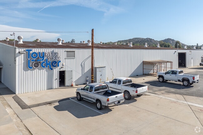
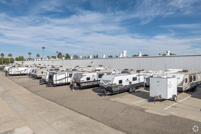
16833 Krameria Ave
Inland Empire (California)
Amended Map Woodcres
Riverside-San Bernardino-Ontario, CA
ACRES 11.81000000 ACREAGEQUALCODE AC LOT 2-P LOTTYPE L MAPPLATB 018 MAPPLATP 039 SUBDIVISIONNAME AMENDED MAP WOODCRES
273-180-058
Riverside
Lightindustrial
California
2024
2-p
2025
11.81 AC
042003
Riverside
102,910 SF
DEMOGRAPHICS near 16833 Krameria Ave
1 Mile
3 Mile
5 Mile
2024 Total Population
4,069
32,834
117,880
2029 Population
4,288
34,527
124,024
Pop Growth 2024-2029
+ 5.38%
+ 5.16%
+ 5.21%
Average Age
40
39
38
2024 Total Households
1,188
9,422
34,521
HH Growth 2024-2029
+ 4.97%
+ 4.70%
+ 4.81%
Median Household Inc
$128,033
$128,855
$109,139
Avg Household Size
3.20
3.30
3.20
2024 Avg HH Vehicles
3.00
3.00
3.00
Median Home Value
$702,734
$707,854
$639,232
Median Year Built
1979
1990
1985
Nearby Places
Map Layers
Map Styles
 Street
 Aerial
- Restaurants
- Banks
- Shops
- Fitness
- Groceries
PUBLIC TRANSPORTATION
COMMUTER RAIL
Moreno Valley/March Field (Metrolink 91-Perris Valley Line - Metrolink Trains)
DRIVE
WALK
Distance
Moreno Valley/March Field (Metrolink 91-Perris Valley Line - Metrolink Trains)
12 min
7.3 mi
Riverside-La Sierra (91 Line - Southern California Regional Rail Authority (Metrolink), Inland Empire-Orange County Line - Southern California Regional Rail Authority (Metrolink))
DRIVE
WALK
Distance
Riverside-La Sierra (91 Line - Southern California Regional Rail Authority (Metrolink), Inland Empire-Orange County Line - Southern California Regional Rail Authority (Metrolink))
14 min
7.8 mi
AIRPORT
Ontario International
DRIVE
WALK
Distance
Ontario International
35 min
21.4 mi
Freight Ports
Port of Long Beach
DRIVE
WALK
Distance
Port of Long Beach
73 min
55.5 mi
Nearby Properties
Address
Land Use
TOTAL SIZE
Lot Size
Zoning
Address
Land Use
TOTAL SIZE
Lot Size
Zoning
47,426 SF
4.32 AC
Address
Land Use
TOTAL SIZE
Lot Size
Zoning
86,938 SF
6.94 AC
Address
Land Use
TOTAL SIZE
Lot Size
Zoning
21.60 AC
CPS
Address
Land Use
TOTAL SIZE
Lot Size
Zoning
18,800 SF
3.50 AC
Address
Land Use
TOTAL SIZE
Lot Size
Zoning
15,513 SF
4.86 AC
CPS
Address
Land Use
TOTAL SIZE
Lot Size
Zoning
3.91 AC
Address
Land Use
TOTAL SIZE
Lot Size
Zoning
14,479 SF
1.43 AC
Address
Land Use
TOTAL SIZE
Lot Size
Zoning
43,412 SF
1.81 AC
Address
Land Use
TOTAL SIZE
Lot Size
Zoning
8,201 SF
6.87 AC
Address
Land Use
TOTAL SIZE
Lot Size
Zoning
5,760 SF
35 AC
RA
Address
Land Use
TOTAL SIZE
Lot Size
Zoning
17,272 SF
0.96 AC
CPS
Address
Land Use
TOTAL SIZE
Lot Size
Zoning
40,867 SF
5 AC
Address
Land Use
TOTAL SIZE
Lot Size
Zoning
2,736 SF
119.39 AC
A110
Address
Land Use
TOTAL SIZE
Lot Size
Zoning
6,040 SF
2.15 AC
Address
Land Use
TOTAL SIZE
Lot Size
Zoning
51,688 SF
4.03 AC
C1CP
Address
Land Use
TOTAL SIZE
Lot Size
Zoning
75,930 SF
4.18 AC
C3
Address
Land Use
TOTAL SIZE
Lot Size
Zoning
4,707 SF
0.87 AC
Address
Land Use
TOTAL SIZE
Lot Size
Zoning
2.36 AC
Address
Land Use
TOTAL SIZE
Lot Size
Zoning
2,879 SF
1.41 AC
Address
Land Use
TOTAL SIZE
Lot Size
Zoning
9,648 SF
26.42 AC
R1
Address
Land Use
TOTAL SIZE
Lot Size
Zoning
50.02 AC
A110
Address
Land Use
TOTAL SIZE
Lot Size
Zoning
9,621 SF
0.84 AC
Address
Land Use
TOTAL SIZE
Lot Size
Zoning
960 SF
6.26 AC
RA1
Address
Land Use
TOTAL SIZE
Lot Size
Zoning
24,467 SF
1.38 AC
CPS
Address
Land Use
TOTAL SIZE
Lot Size
Zoning
6,000 SF
0.50 AC
CR
Address
Land Use
TOTAL SIZE
Lot Size
Zoning
2.42 AC
CPS
Address
Land Use
TOTAL SIZE
Lot Size
Zoning
14,136 SF
2.05 AC
The World's #1 Commercial Real Estate Marketplace
Connect with us
© 2025 CoStar Group
The information above has been obtained from sources believed reliable. While we do not doubt its accuracy we have not verified it and make no guarantee, warranty or representation about it. It is your responsibility to independently confirm its accuracy and completeness. Any projections, opinions, assumptions, or estimates used are for example only and do not represent the current or future performance of the property. The value of this transaction to you depends on tax and other factors which should be evaluated by your tax, financial, and legal advisors. You and your advisors should conduct a careful, independent investigation of the property to determine to your satisfaction the suitability of the property for your needs.