Property Record
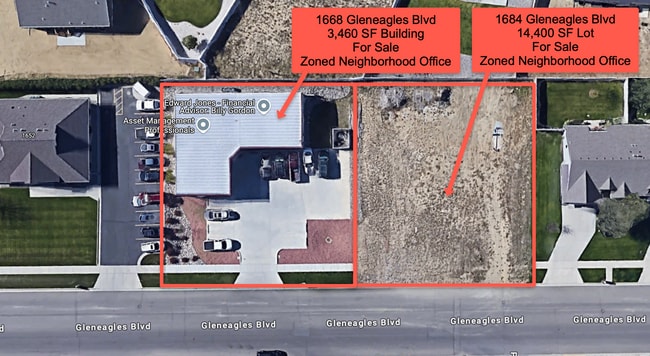
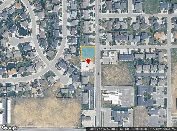
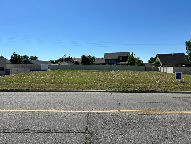
1668 Gleneagles Blvd, Billings, MT 59105
This Property Is For Sale
NEARBY LISTINGS FOR SALE OR LEASE
Property Detail
1668 Gleneagles Blvd
Billings, MT
Lake Hills Subd 1St Filing
03-1033-16-3-01-06-0000
LAKE HILLS SUBD 1ST FILING, S16, T01 N, R26 E, BLOCK 1, LOT 6
Commercialacreage
Yellowstone
X
Montana
30111C1260E
6
2024
0.33 AC
2025
Billings
000701
Other Market Areas
DEMOGRAPHICS near 1668 Gleneagles Blvd
1 Mile
3 Mile
5 Mile
2024 Total Population
9,633
38,988
92,072
2029 Population
10,896
43,580
102,429
Pop Growth 2024-2029
+ 13.11%
+ 11.78%
+ 11.25%
Average Age
38
39
40
2024 Total Households
3,638
15,823
38,466
HH Growth 2024-2029
+ 13.52%
+ 12.28%
+ 11.78%
Median Household Inc
$81,507
$69,478
$65,461
Avg Household Size
2.60
2.40
2.30
2024 Avg HH Vehicles
2.00
2.00
2.00
Median Home Value
$374,070
$354,403
$337,211
Median Year Built
1994
1983
1973
Nearby Places
- Restaurants
- Banks
- Shops
- Fitness
- Groceries
PUBLIC TRANSPORTATION
AIRPORT
Billings Logan International
DRIVE
WALK
Distance
Billings Logan International
26 min
8.5 mi
Freight Ports
Port of Everett
DRIVE
WALK
Distance
Port of Everett
894 min
846.3 mi
Nearby Properties
Address
Land Use
TOTAL SIZE
Lot Size
Zoning
Address
Land Use
TOTAL SIZE
Lot Size
Zoning
650,098 SF
53.35 AC
CI
Address
Land Use
TOTAL SIZE
Lot Size
Zoning
704,701 SF
9.06 AC
MCPZD
Address
Land Use
TOTAL SIZE
Lot Size
Zoning
615,777 SF
5.85 AC
MCPZD
Address
Land Use
TOTAL SIZE
Lot Size
Zoning
1,542.56 AC
P
Address
Land Use
TOTAL SIZE
Lot Size
Zoning
6,000 SF
152.47 AC
PUBLIC-COU
Address
Land Use
TOTAL SIZE
Lot Size
Zoning
228,269 SF
44.60 AC
PUBLIC-CIT
Address
Land Use
TOTAL SIZE
Lot Size
Zoning
198,096 SF
7.48 AC
MCPZD
Address
Land Use
TOTAL SIZE
Lot Size
Zoning
9.37 AC
P
Address
Land Use
TOTAL SIZE
Lot Size
Zoning
117,130 SF
29.86 AC
R-70
Address
Land Use
TOTAL SIZE
Lot Size
Zoning
108,000 SF
2.07 AC
CBD
Address
Land Use
TOTAL SIZE
Lot Size
Zoning
109,714 SF
NC
Address
Land Use
TOTAL SIZE
Lot Size
Zoning
141,056 SF
25.82 AC
PUBLIC-CIT
Address
Land Use
TOTAL SIZE
Lot Size
Zoning
234,444 SF
4.98 AC
MCPZD
Address
Land Use
TOTAL SIZE
Lot Size
Zoning
63,650 SF
4.13 AC
MCPZD
Address
Land Use
TOTAL SIZE
Lot Size
Zoning
181,007 SF
19.57 AC
Address
Land Use
TOTAL SIZE
Lot Size
Zoning
48,717 SF
1.53 AC
MCPZD
Address
Land Use
TOTAL SIZE
Lot Size
Zoning
125,400 SF
2.41 AC
CI
Address
Land Use
TOTAL SIZE
Lot Size
Zoning
72,000 SF
0.31 AC
MCPZD
Address
Land Use
TOTAL SIZE
Lot Size
Zoning
78,328 SF
7.78 AC
R9600-CITY
Address
Land Use
TOTAL SIZE
Lot Size
Zoning
62,136 SF
2.24 AC
MCPZD
Address
Land Use
TOTAL SIZE
Lot Size
Zoning
68,022 SF
4.01 AC
CI
Address
Land Use
TOTAL SIZE
Lot Size
Zoning
53.34 AC
P
Address
Land Use
TOTAL SIZE
Lot Size
Zoning
57,112 SF
7.69 AC
Address
Land Use
TOTAL SIZE
Lot Size
Zoning
0.37 AC
Address
Land Use
TOTAL SIZE
Lot Size
Zoning
163,943 SF
2.09 AC
Address
Land Use
TOTAL SIZE
Lot Size
Zoning
25,045 SF
10.77 AC
R-70
Address
Land Use
TOTAL SIZE
Lot Size
Zoning
110,086 SF
1.49 AC
MCPZD
Address
Land Use
TOTAL SIZE
Lot Size
Zoning
34,632 SF
MCPZD
Address
Land Use
TOTAL SIZE
Lot Size
Zoning
43.08 AC
R-96
Address
Land Use
TOTAL SIZE
Lot Size
Zoning
53,483 SF
1.13 AC
RP
The World's #1 Commercial Real Estate Marketplace
Connect with us
© 2025 CoStar Group
The information above has been obtained from sources believed reliable. While we do not doubt its accuracy we have not verified it and make no guarantee, warranty or representation about it. It is your responsibility to independently confirm its accuracy and completeness. Any projections, opinions, assumptions, or estimates used are for example only and do not represent the current or future performance of the property. The value of this transaction to you depends on tax and other factors which should be evaluated by your tax, financial, and legal advisors. You and your advisors should conduct a careful, independent investigation of the property to determine to your satisfaction the suitability of the property for your needs.