Property Record
1684 Woodman Dr, Dayton, OH 45432
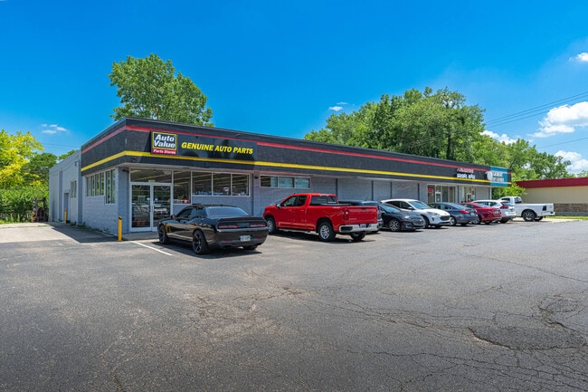

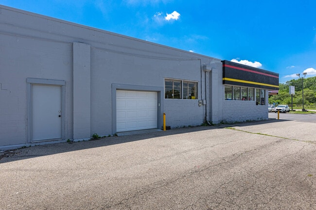
This Property Is For Sale
Property Detail
1684 Woodman Dr
Dayton, OH
73441 PT
R72-16501-0005
Montgomery
Storebuilding
Ohio
B and X Area of moderate flood hazard, usually the area between the limits of the 100-year and 500-year floods.
5
2024
0.82 AC
2025
South Central Dayton
002800
Cincinnati/Dayton
9,396 SF
NEARBY LISTINGS FOR SALE OR LEASE
DEMOGRAPHICS near 1684 Woodman Dr
1 mile
3 mile
5 mile
2025 Total Population
9,033
104,186
211,562
2030 Population
8,883
104,542
214,091
Pop Growth 2025-2030
(1.66%)
+ 0.34%
+ 1.20%
Average Age
42
38
39
2025 Total Households
4,305
44,051
89,453
HH Growth 2025-2030
(1.63%)
+ 0.30%
+ 1.21%
Median Household Inc
$57,244
$62,495
$66,301
Avg Household Size
2.10
2.20
2.20
2025 Avg HH Vehicles
2.00
2.00
2.00
Median Home Value
$132,785
$162,582
$206,876
Median Year Built
1951
1955
1959
Nearby Places
Map Layers
Map Styles
 Street
 Aerial
Layers
 Traffic
 Biking
Places
Listings with unknown addresses are not visible on the map
- Restaurants
- Banks
- Shops
- Fitness
- Groceries
PUBLIC TRANSPORTATION
AIRPORT
James M Cox Dayton International
Drive
Walk
Distance
James M Cox Dayton International
29 min
17.2 mi
Nearby Properties
Address
Land Use
TOTAL SIZE
Lot Size
Zoning
Address
Land Use
TOTAL SIZE
Lot Size
Zoning
634,753 SF
54 AC
Address
Land Use
TOTAL SIZE
Lot Size
Zoning
414,094 SF
36.48 AC
Address
Land Use
TOTAL SIZE
Lot Size
Zoning
316.77 AC
Address
Land Use
TOTAL SIZE
Lot Size
Zoning
752,874 SF
74.85 AC
Address
Land Use
TOTAL SIZE
Lot Size
Zoning
240,090 SF
1.93 AC
MXPUD02
Address
Land Use
TOTAL SIZE
Lot Size
Zoning
23.35 AC
Address
Land Use
TOTAL SIZE
Lot Size
Zoning
175,938 SF
49.33 AC
Address
Land Use
TOTAL SIZE
Lot Size
Zoning
53.48 AC
RP1
Address
Land Use
TOTAL SIZE
Lot Size
Zoning
1,951 SF
56.54 AC
Address
Land Use
TOTAL SIZE
Lot Size
Zoning
130,247 SF
14.12 AC
Address
Land Use
TOTAL SIZE
Lot Size
Zoning
Address
Land Use
TOTAL SIZE
Lot Size
Zoning
133.37 AC
Address
Land Use
TOTAL SIZE
Lot Size
Zoning
4.86 AC
Address
Land Use
TOTAL SIZE
Lot Size
Zoning
41.38 AC
Address
Land Use
TOTAL SIZE
Lot Size
Zoning
54.85 AC
Address
Land Use
TOTAL SIZE
Lot Size
Zoning
46.32 AC
Address
Land Use
TOTAL SIZE
Lot Size
Zoning
32.30 AC
Address
Land Use
TOTAL SIZE
Lot Size
Zoning
1,008 SF
7 AC
R1A
Address
Land Use
TOTAL SIZE
Lot Size
Zoning
4.98 AC
Address
Land Use
TOTAL SIZE
Lot Size
Zoning
109,680 SF
32.24 AC
R4
Address
Land Use
TOTAL SIZE
Lot Size
Zoning
5.95 AC
Address
Land Use
TOTAL SIZE
Lot Size
Zoning
100,450 SF
1.66 AC
MXPUD02
Address
Land Use
TOTAL SIZE
Lot Size
Zoning
148,309 SF
1.50 AC
MXPUD02
Address
Land Use
TOTAL SIZE
Lot Size
Zoning
94,608 SF
7.44 AC
Address
Land Use
TOTAL SIZE
Lot Size
Zoning
152,844 SF
14.80 AC
Address
Land Use
TOTAL SIZE
Lot Size
Zoning
89,176 SF
17.52 AC
Address
Land Use
TOTAL SIZE
Lot Size
Zoning
54,604 SF
6.29 AC
MXPUD02
Address
Land Use
TOTAL SIZE
Lot Size
Zoning
309,331 SF
36 AC
Address
Land Use
TOTAL SIZE
Lot Size
Zoning
256,686 SF
11.05 AC
Address
Land Use
TOTAL SIZE
Lot Size
Zoning
23.20 AC
The World's #1 Commercial Real Estate Marketplace
Connect with us
© 2026 CoStar Group
The information above has been obtained from sources believed reliable. While we do not doubt its accuracy we have not verified it and make no guarantee, warranty or representation about it. It is your responsibility to independently confirm its accuracy and completeness. Any projections, opinions, assumptions, or estimates used are for example only and do not represent the current or future performance of the property. The value of this transaction to you depends on tax and other factors which should be evaluated by your tax, financial, and legal advisors. You and your advisors should conduct a careful, independent investigation of the property to determine to your satisfaction the suitability of the property for your needs.