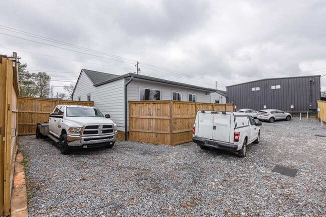
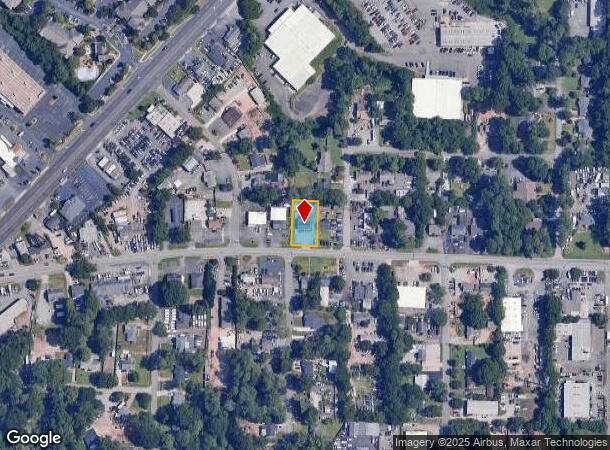
Property Record
1685 Lower Roswell Rd, Marietta, GA 30068
Current Lease Availabilities
NEARBY LISTINGS FOR SALE OR LEASE
Property Detail
1685 Lower Roswell Rd
16-1207-0-042-0
L N Harris
Commercialnec
Cobb
X
Georgia
13067C0109H
22
2025
0.28 AC
2025
Kennesaw/Town Center
030410
Atlanta
2,062 SF
Atlanta-Sandy Springs-Roswell, GA
DEMOGRAPHICS near 1685 Lower Roswell Rd
1 Mile
3 Mile
5 Mile
2024 Total Population
9,021
79,748
222,081
2029 Population
9,199
81,671
226,184
Pop Growth 2024-2029
+ 1.97%
+ 2.41%
+ 1.85%
Average Age
36
37
38
2024 Total Households
3,817
31,933
90,902
HH Growth 2024-2029
+ 1.91%
+ 2.42%
+ 1.82%
Median Household Inc
$56,623
$69,917
$77,170
Avg Household Size
2.20
2.40
2.40
2024 Avg HH Vehicles
2.00
2.00
2.00
Median Home Value
$236,916
$361,620
$368,828
Median Year Built
1978
1981
1983
Nearby Places
Map Layers
Map Styles
 Street
 Aerial
- Restaurants
- Banks
- Shops
- Fitness
- Groceries
PUBLIC TRANSPORTATION
AIRPORT
Hartsfield - Jackson Atlanta International
DRIVE
WALK
Distance
Hartsfield - Jackson Atlanta International
37 min
26.4 mi
Nearby Properties
Address
Land Use
TOTAL SIZE
Lot Size
Zoning
Address
Land Use
TOTAL SIZE
Lot Size
Zoning
379,750 SF
11.14 AC
Address
Land Use
TOTAL SIZE
Lot Size
Zoning
643,086 SF
40.63 AC
RM-12
Address
Land Use
TOTAL SIZE
Lot Size
Zoning
437,793 SF
41.12 AC
RM-16
Address
Land Use
TOTAL SIZE
Lot Size
Zoning
452,366 SF
27.27 AC
PRD MF
Address
Land Use
TOTAL SIZE
Lot Size
Zoning
494,076 SF
33.30 AC
PRD MF
Address
Land Use
TOTAL SIZE
Lot Size
Zoning
582,685 SF
37.58 AC
PVC
Address
Land Use
TOTAL SIZE
Lot Size
Zoning
300,105 SF
43.12 AC
RM-8
Address
Land Use
TOTAL SIZE
Lot Size
Zoning
343,570 SF
22.65 AC
PRD MF
Address
Land Use
TOTAL SIZE
Lot Size
Zoning
8,000 SF
9.57 AC
PRD MF
Address
Land Use
TOTAL SIZE
Lot Size
Zoning
464,381 SF
34.82 AC
RM-12
Address
Land Use
TOTAL SIZE
Lot Size
Zoning
376,618 SF
22.82 AC
RM-12
Address
Land Use
TOTAL SIZE
Lot Size
Zoning
393,980 SF
20.16 AC
PRD MF
Address
Land Use
TOTAL SIZE
Lot Size
Zoning
284,832 SF
19.56 AC
PRD MF
Address
Land Use
TOTAL SIZE
Lot Size
Zoning
243,574 SF
40.05 AC
RM-8
Address
Land Use
TOTAL SIZE
Lot Size
Zoning
290,588 SF
21.54 AC
RM-16
Address
Land Use
TOTAL SIZE
Lot Size
Zoning
129,168 SF
0.82 AC
OI
Address
Land Use
TOTAL SIZE
Lot Size
Zoning
285,846 SF
19.21 AC
PRD MF
Address
Land Use
TOTAL SIZE
Lot Size
Zoning
8,980 SF
51.17 AC
Address
Land Use
TOTAL SIZE
Lot Size
Zoning
243,288 SF
18.80 AC
RM-12
Address
Land Use
TOTAL SIZE
Lot Size
Zoning
347,671 SF
23.59 AC
RM-12
Address
Land Use
TOTAL SIZE
Lot Size
Zoning
228,652 SF
24.19 AC
RM-12
Address
Land Use
TOTAL SIZE
Lot Size
Zoning
509,792 SF
4.45 AC
OHR
Address
Land Use
TOTAL SIZE
Lot Size
Zoning
258,668 SF
21.54 AC
RM-16
Address
Land Use
TOTAL SIZE
Lot Size
Zoning
226,769 SF
13.40 AC
RM-16
Address
Land Use
TOTAL SIZE
Lot Size
Zoning
296,720 SF
17.31 AC
RM-12
Address
Land Use
TOTAL SIZE
Lot Size
Zoning
190,168 SF
14.60 AC
PRD MF
Address
Land Use
TOTAL SIZE
Lot Size
Zoning
226,810 SF
9.95 AC
PRD MF
Address
Land Use
TOTAL SIZE
Lot Size
Zoning
240,389 SF
18.32 AC
PRD MF
Address
Land Use
TOTAL SIZE
Lot Size
Zoning
240,628 SF
30.90 AC
RM-8
Address
Land Use
TOTAL SIZE
Lot Size
Zoning
232,894 SF
13.88 AC
PRD MF
The World's #1 Commercial Real Estate Marketplace
Connect with us
© 2025 CoStar Group
The information above has been obtained from sources believed reliable. While we do not doubt its accuracy we have not verified it and make no guarantee, warranty or representation about it. It is your responsibility to independently confirm its accuracy and completeness. Any projections, opinions, assumptions, or estimates used are for example only and do not represent the current or future performance of the property. The value of this transaction to you depends on tax and other factors which should be evaluated by your tax, financial, and legal advisors. You and your advisors should conduct a careful, independent investigation of the property to determine to your satisfaction the suitability of the property for your needs.