Property Record
16865 Us Highway 17, Hampstead, NC 28443
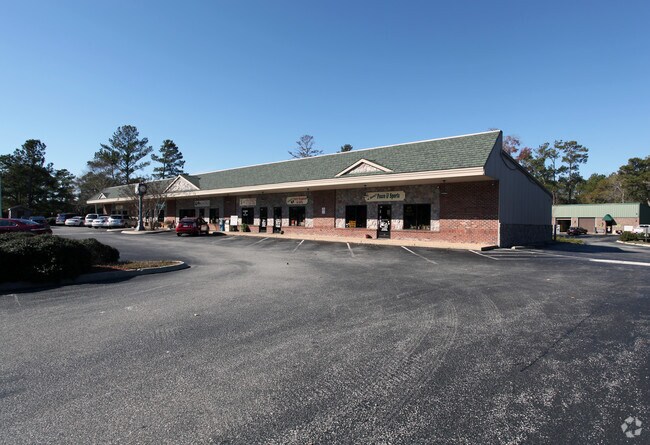

Property Detail
16865 Us Highway 17
3293-65-9627-0000
2 TRACTS
Storebuilding
Pender
SEEMAP
North Carolina
B and X Area of moderate flood hazard, usually the area between the limits of the 100-year and 500-year floods.
3 AC
2025
East Pender County
2025
Wilmington
920203
Wilmington, NC
10,000 SF
NEARBY LISTINGS FOR SALE OR LEASE
-
-
-
No Photo
-
-
-
-
View all Hampstead listings for sale on LoopNet.com
DEMOGRAPHICS near 16865 Us Highway 17
1 mile
3 mile
5 mile
2025 Total Population
2,101
14,372
23,513
2030 Population
2,374
16,199
26,533
Pop Growth 2025-2030
+ 12.99%
+ 12.71%
+ 12.84%
Average Age
41
41
41
2025 Total Households
835
5,526
8,941
HH Growth 2025-2030
+ 13.29%
+ 13.10%
+ 13.28%
Median Household Inc
$89,374
$92,390
$94,801
Avg Household Size
2.50
2.60
2.60
2025 Avg HH Vehicles
2.00
2.00
2.00
Median Home Value
$384,976
$401,446
$418,530
Median Year Built
2003
2003
2003
Nearby Places
Map Layers
Map Styles
 Street
 Aerial
Layers
 Traffic
 Biking
Places
Listings with unknown addresses are not visible on the map
- Restaurants
- Banks
- Shops
- Fitness
- Groceries
PUBLIC TRANSPORTATION
AIRPORT
Wilmington International
Drive
Walk
Distance
Wilmington International
33 min
20.7 mi
Albert J Ellis
Drive
Walk
Distance
Albert J Ellis
68 min
43.0 mi
Freight Ports
Port of Wilmington
Drive
Walk
Distance
Port of Wilmington
40 min
28.4 mi
Nearby Properties
Address
Land Use
TOTAL SIZE
Lot Size
Zoning
Address
Land Use
TOTAL SIZE
Lot Size
Zoning
187,606 SF
18 AC
SEEMAP
Address
Land Use
TOTAL SIZE
Lot Size
Zoning
80,712 SF
16.69 AC
Address
Land Use
TOTAL SIZE
Lot Size
Zoning
93,200 SF
20 AC
SEEMAP
Address
Land Use
TOTAL SIZE
Lot Size
Zoning
33,891 SF
38.51 AC
PD
Address
Land Use
TOTAL SIZE
Lot Size
Zoning
62,893 SF
24.19 AC
PD
Address
Land Use
TOTAL SIZE
Lot Size
Zoning
90,501 SF
7.03 AC
GB
Address
Land Use
TOTAL SIZE
Lot Size
Zoning
6,364 SF
11.40 AC
R20
Address
Land Use
TOTAL SIZE
Lot Size
Zoning
49,095 SF
11 AC
SEEMAP
Address
Land Use
TOTAL SIZE
Lot Size
Zoning
63,886 SF
11.51 AC
PD
Address
Land Use
TOTAL SIZE
Lot Size
Zoning
79,660 SF
13.24 AC
PD
Address
Land Use
TOTAL SIZE
Lot Size
Zoning
21,295 SF
9.39 AC
PD
Address
Land Use
TOTAL SIZE
Lot Size
Zoning
8.48 AC
PD
Address
Land Use
TOTAL SIZE
Lot Size
Zoning
45,636 SF
6.45 AC
GB
Address
Land Use
TOTAL SIZE
Lot Size
Zoning
49,000 SF
4.29 AC
Address
Land Use
TOTAL SIZE
Lot Size
Zoning
24,000 SF
2.79 AC
B2
Address
Land Use
TOTAL SIZE
Lot Size
Zoning
16,748 SF
6.26 AC
SEEMAP
Address
Land Use
TOTAL SIZE
Lot Size
Zoning
8.48 AC
PD
Address
Land Use
TOTAL SIZE
Lot Size
Zoning
8.48 AC
PD
Address
Land Use
TOTAL SIZE
Lot Size
Zoning
8.48 AC
PD
Address
Land Use
TOTAL SIZE
Lot Size
Zoning
8.48 AC
PD
Address
Land Use
TOTAL SIZE
Lot Size
Zoning
8.48 AC
PD
Address
Land Use
TOTAL SIZE
Lot Size
Zoning
11,828 SF
1 AC
Address
Land Use
TOTAL SIZE
Lot Size
Zoning
8.48 AC
PD
Address
Land Use
TOTAL SIZE
Lot Size
Zoning
8.48 AC
PD
Address
Land Use
TOTAL SIZE
Lot Size
Zoning
8.48 AC
PD
Address
Land Use
TOTAL SIZE
Lot Size
Zoning
12,452 SF
1.16 AC
Address
Land Use
TOTAL SIZE
Lot Size
Zoning
8.48 AC
PD
Address
Land Use
TOTAL SIZE
Lot Size
Zoning
174 SF
FA
Address
Land Use
TOTAL SIZE
Lot Size
Zoning
8.48 AC
PD
The World's #1 Commercial Real Estate Marketplace
Connect with us
© 2026 CoStar Group
The information above has been obtained from sources believed reliable. While we do not doubt its accuracy we have not verified it and make no guarantee, warranty or representation about it. It is your responsibility to independently confirm its accuracy and completeness. Any projections, opinions, assumptions, or estimates used are for example only and do not represent the current or future performance of the property. The value of this transaction to you depends on tax and other factors which should be evaluated by your tax, financial, and legal advisors. You and your advisors should conduct a careful, independent investigation of the property to determine to your satisfaction the suitability of the property for your needs.