Property Record
169 5Th St Se, Barberton, OH 44203

Save to a Folder
{{folder.Name}}
{{folder.ListingIds.length}} Properties
{{folder.ListingIds.length}} Property
Create a New Folder
Current Lease Availabilities
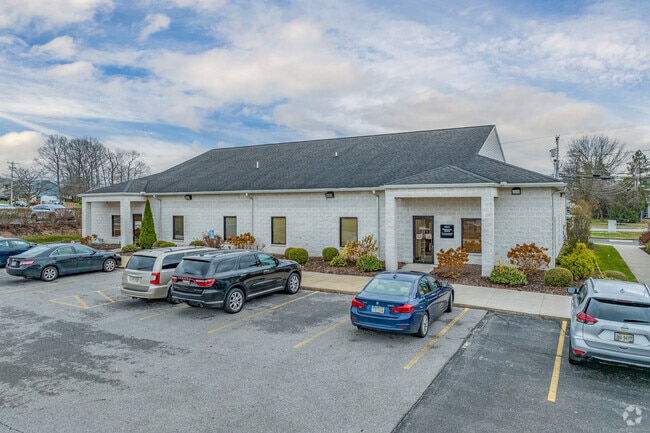
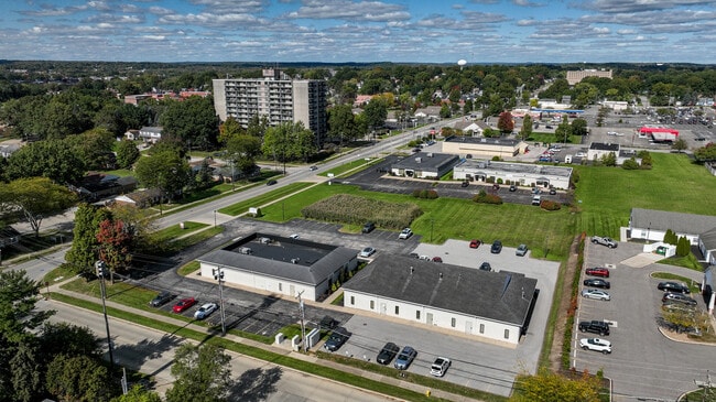
Property Detail
169 5Th St Se
Akron, OH
AUSTIN SQUARE PT PARCELS F J & K PB 122 PG 35-37 .6047 AC
01-16725
Summit
Medicalbuilding
Ohio
B and X Area of moderate flood hazard, usually the area between the limits of the 100-year and 500-year floods.
17
2025
0.61 AC
2026
Akron
510302
Cleveland
6,000 SF
NEARBY LISTINGS FOR SALE OR LEASE
DEMOGRAPHICS near 169 5Th St Se
1 mile
3 mile
5 mile
2025 Total Population
8,594
44,504
103,328
2030 Population
8,584
44,501
103,451
Pop Growth 2025-2030
(0.12%)
(0.01%)
+ 0.12%
Average Age
44
43
42
2025 Total Households
3,869
19,527
44,521
HH Growth 2025-2030
(0.21%)
(0.03%)
+ 0.09%
Median Household Inc
$37,885
$54,768
$55,790
Avg Household Size
2.10
2.20
2.30
2025 Avg HH Vehicles
1.00
2.00
2.00
Median Home Value
$163,711
$148,919
$153,682
Median Year Built
1970
1955
1956
Nearby Places
Map Layers
Map Styles
 Street
 Aerial
Layers
 Traffic
 Biking
Places
Listings with unknown addresses are not visible on the map
- Restaurants
- Banks
- Shops
- Fitness
- Groceries
PUBLIC TRANSPORTATION
AIRPORT
Akron-Canton Regional
Drive
Walk
Distance
Akron-Canton Regional
22 min
12.8 mi
Cleveland-Hopkins International
Drive
Walk
Distance
Cleveland-Hopkins International
62 min
42.2 mi
Nearby Properties
Address
Land Use
TOTAL SIZE
Lot Size
Zoning
Address
Land Use
TOTAL SIZE
Lot Size
Zoning
1,397,532 SF
92.95 AC
Address
Land Use
TOTAL SIZE
Lot Size
Zoning
252,222 SF
12.65 AC
Address
Land Use
TOTAL SIZE
Lot Size
Zoning
Address
Land Use
TOTAL SIZE
Lot Size
Zoning
Address
Land Use
TOTAL SIZE
Lot Size
Zoning
132,611 SF
3.56 AC
Address
Land Use
TOTAL SIZE
Lot Size
Zoning
166,625 SF
11.37 AC
Address
Land Use
TOTAL SIZE
Lot Size
Zoning
227,634 SF
21.46 AC
Address
Land Use
TOTAL SIZE
Lot Size
Zoning
Address
Land Use
TOTAL SIZE
Lot Size
Zoning
24,812 SF
29.15 AC
Address
Land Use
TOTAL SIZE
Lot Size
Zoning
91,678 SF
5.24 AC
Address
Land Use
TOTAL SIZE
Lot Size
Zoning
Address
Land Use
TOTAL SIZE
Lot Size
Zoning
295,142 SF
24.69 AC
Address
Land Use
TOTAL SIZE
Lot Size
Zoning
1,020,023 SF
58.70 AC
Address
Land Use
TOTAL SIZE
Lot Size
Zoning
142,266 SF
8.15 AC
Address
Land Use
TOTAL SIZE
Lot Size
Zoning
87,486 SF
7.25 AC
Address
Land Use
TOTAL SIZE
Lot Size
Zoning
59,492 SF
5.51 AC
Address
Land Use
TOTAL SIZE
Lot Size
Zoning
204,276 SF
28.95 AC
Address
Land Use
TOTAL SIZE
Lot Size
Zoning
53,074 SF
7.29 AC
Address
Land Use
TOTAL SIZE
Lot Size
Zoning
130,893 SF
11.70 AC
Address
Land Use
TOTAL SIZE
Lot Size
Zoning
Address
Land Use
TOTAL SIZE
Lot Size
Zoning
249,954 SF
33.57 AC
Address
Land Use
TOTAL SIZE
Lot Size
Zoning
253,690 SF
12.18 AC
Address
Land Use
TOTAL SIZE
Lot Size
Zoning
34.80 AC
Address
Land Use
TOTAL SIZE
Lot Size
Zoning
5,520 SF
68.52 AC
Address
Land Use
TOTAL SIZE
Lot Size
Zoning
112,894 SF
12.26 AC
Address
Land Use
TOTAL SIZE
Lot Size
Zoning
77,444 SF
13.02 AC
Address
Land Use
TOTAL SIZE
Lot Size
Zoning
17.87 AC
Address
Land Use
TOTAL SIZE
Lot Size
Zoning
20,000 SF
23.71 AC
Address
Land Use
TOTAL SIZE
Lot Size
Zoning
70,783 SF
15.97 AC
Address
Land Use
TOTAL SIZE
Lot Size
Zoning
122,390 SF
9.26 AC
The World's #1 Commercial Real Estate Marketplace
Connect with us
© 2026 CoStar Group
The information above has been obtained from sources believed reliable. While we do not doubt its accuracy we have not verified it and make no guarantee, warranty or representation about it. It is your responsibility to independently confirm its accuracy and completeness. Any projections, opinions, assumptions, or estimates used are for example only and do not represent the current or future performance of the property. The value of this transaction to you depends on tax and other factors which should be evaluated by your tax, financial, and legal advisors. You and your advisors should conduct a careful, independent investigation of the property to determine to your satisfaction the suitability of the property for your needs.