Property Record
169 Otto Cir, Sacramento, CA 95822
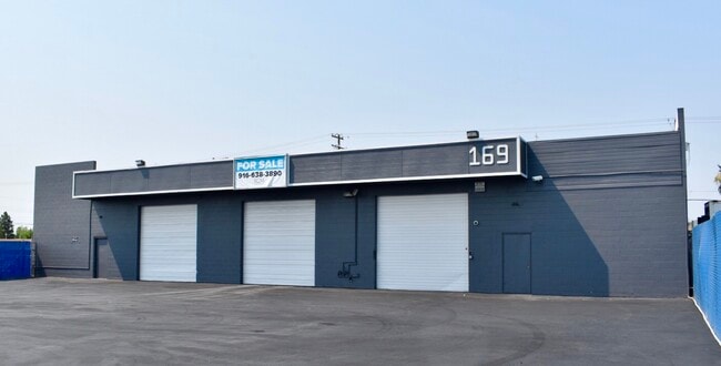

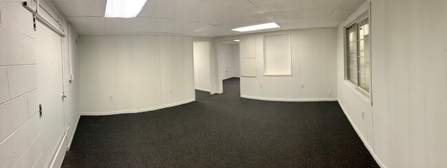

This Property Is For Sale
NEARBY LISTINGS FOR SALE OR LEASE
Property Detail
169 Otto Cir
Sacramento--Roseville--Arden-Arcade, CA
Industrial City
036-0192-005
INDUSTRIAL CITY, LOT 10
Warehouse
Sacramento
X
California
06067C0190H
10
2024
0.42 AC
2025
South Sacramento
004100
Sacramento
9,970 SF
DEMOGRAPHICS near 169 Otto Cir
1 Mile
3 Mile
5 Mile
2024 Total Population
17,886
182,109
380,973
2029 Population
18,028
183,347
384,032
Pop Growth 2024-2029
+ 0.79%
+ 0.68%
+ 0.80%
Average Age
36
38
38
2024 Total Households
5,536
61,657
139,577
HH Growth 2024-2029
+ 0.78%
+ 0.66%
+ 0.90%
Median Household Inc
$51,503
$64,224
$71,239
Avg Household Size
3.10
2.80
2.60
2024 Avg HH Vehicles
2.00
2.00
2.00
Median Home Value
$315,863
$400,096
$452,110
Median Year Built
1965
1966
1970
Nearby Places
Map Layers
Map Styles
 Street
 Aerial
- Restaurants
- Banks
- Shops
- Fitness
- Groceries
PUBLIC TRANSPORTATION
COMMUTER RAIL
DRIVE
WALK
Distance
14 min
8.1 mi
AIRPORT
Sacramento International
DRIVE
WALK
Distance
Sacramento International
28 min
17.7 mi
Nearby Properties
Address
Land Use
TOTAL SIZE
Lot Size
Zoning
Address
Land Use
TOTAL SIZE
Lot Size
Zoning
12.70 AC
SC-PUD
Address
Land Use
TOTAL SIZE
Lot Size
Zoning
253,984 SF
11.58 AC
R-2B-PUD
Address
Land Use
TOTAL SIZE
Lot Size
Zoning
213,260 SF
14.35 AC
R-3-R
Address
Land Use
TOTAL SIZE
Lot Size
Zoning
53,386 SF
7.75 AC
C-2-SPD
Address
Land Use
TOTAL SIZE
Lot Size
Zoning
166,941 SF
7.46 AC
R-2B-PUD
Address
Land Use
TOTAL SIZE
Lot Size
Zoning
64,082 SF
2.38 AC
R-1
Address
Land Use
TOTAL SIZE
Lot Size
Zoning
213,445 SF
18.25 AC
SC
Address
Land Use
TOTAL SIZE
Lot Size
Zoning
186.36 AC
R-1-PUD R-
Address
Land Use
TOTAL SIZE
Lot Size
Zoning
267,580 SF
16.12 AC
R-1A
Address
Land Use
TOTAL SIZE
Lot Size
Zoning
Address
Land Use
TOTAL SIZE
Lot Size
Zoning
102,930 SF
4.87 AC
R-3
Address
Land Use
TOTAL SIZE
Lot Size
Zoning
181,766 SF
4.79 AC
R-4-PUD R-
Address
Land Use
TOTAL SIZE
Lot Size
Zoning
95,548 SF
24.25 AC
R-1
Address
Land Use
TOTAL SIZE
Lot Size
Zoning
227,396 SF
15.76 AC
R-2A-R-EA-
Address
Land Use
TOTAL SIZE
Lot Size
Zoning
91,586 SF
6.03 AC
R-3-R
Address
Land Use
TOTAL SIZE
Lot Size
Zoning
95,427 SF
7.07 AC
LC
Address
Land Use
TOTAL SIZE
Lot Size
Zoning
100,704 SF
5.63 AC
RD-20
Address
Land Use
TOTAL SIZE
Lot Size
Zoning
84,087 SF
4.11 AC
R-3-R
Address
Land Use
TOTAL SIZE
Lot Size
Zoning
162,259 SF
12.73 AC
R-3
Address
Land Use
TOTAL SIZE
Lot Size
Zoning
165,523 SF
15.76 AC
A-PUD OB-P
Address
Land Use
TOTAL SIZE
Lot Size
Zoning
100,787 SF
8.78 AC
SPA
Address
Land Use
TOTAL SIZE
Lot Size
Zoning
45,949 SF
4.24 AC
R-2A
Address
Land Use
TOTAL SIZE
Lot Size
Zoning
53,967 SF
8.77 AC
SC-PUD
Address
Land Use
TOTAL SIZE
Lot Size
Zoning
129,305 SF
9.37 AC
C-2-SPD
Address
Land Use
TOTAL SIZE
Lot Size
Zoning
55,537 SF
3.67 AC
SC-PUD
Address
Land Use
TOTAL SIZE
Lot Size
Zoning
29.28 AC
C-2-PUD
Address
Land Use
TOTAL SIZE
Lot Size
Zoning
85,429 SF
3.67 AC
F C-2-R
Address
Land Use
TOTAL SIZE
Lot Size
Zoning
111,196 SF
5.40 AC
C-2-R
Address
Land Use
TOTAL SIZE
Lot Size
Zoning
55,164 SF
9.09 AC
C-2-EA-4 C
Address
Land Use
TOTAL SIZE
Lot Size
Zoning
79,915 SF
3.70 AC
R-3
The World's #1 Commercial Real Estate Marketplace
Connect with us
© 2025 CoStar Group
The information above has been obtained from sources believed reliable. While we do not doubt its accuracy we have not verified it and make no guarantee, warranty or representation about it. It is your responsibility to independently confirm its accuracy and completeness. Any projections, opinions, assumptions, or estimates used are for example only and do not represent the current or future performance of the property. The value of this transaction to you depends on tax and other factors which should be evaluated by your tax, financial, and legal advisors. You and your advisors should conduct a careful, independent investigation of the property to determine to your satisfaction the suitability of the property for your needs.