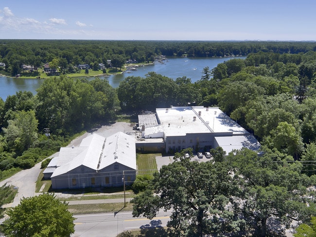
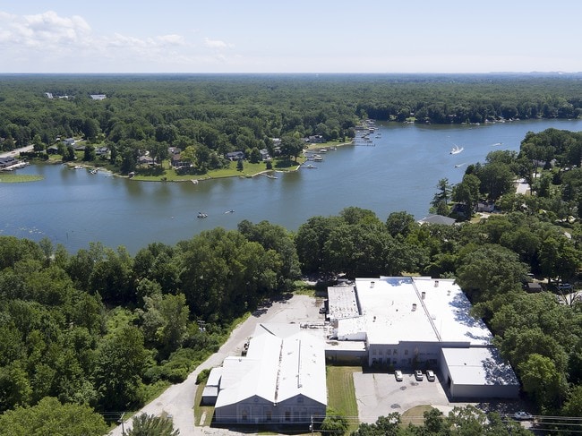
Property Record
169 Park St, Fruitport, MI 49415

Current Lease Availabilities
NEARBY LISTINGS FOR SALE OR LEASE
Property Detail
169 Park St
Muskegon, MI
Village Of Fruitport
41-150-031-0001-00
VILLAGE OF FRUITPORT PART OF BLOCKS 30 AND 31 PLAT OF CRAWVILLE NOW FRUITPORT AND PART OF VACATED LAKE STREET AND VACATED FIF
Industrialgeneral
Muskegon
X
Michigan
26139C0081F
1,3-6
2024
2.85 AC
2025
Norton Shores
002800
West Michigan
44,626 SF
DEMOGRAPHICS near 169 Park St
1 Mile
3 Mile
5 Mile
2024 Total Population
3,018
14,460
43,804
2029 Population
3,075
15,008
45,314
Pop Growth 2024-2029
+ 1.89%
+ 3.79%
+ 3.45%
Average Age
42
42
42
2024 Total Households
1,182
5,733
17,744
HH Growth 2024-2029
+ 1.95%
+ 3.89%
+ 3.61%
Median Household Inc
$90,908
$72,060
$71,353
Avg Household Size
2.50
2.50
2.40
2024 Avg HH Vehicles
2.00
2.00
2.00
Median Home Value
$234,690
$269,862
$247,518
Median Year Built
1976
1990
1983
Nearby Places
Map Layers
Map Styles
 Street
 Aerial
- Restaurants
- Banks
- Shops
- Fitness
- Groceries
Nearby Properties
Address
Land Use
TOTAL SIZE
Lot Size
Zoning
Address
Land Use
TOTAL SIZE
Lot Size
Zoning
381,476 SF
17.96 AC
I INDU
Address
Land Use
TOTAL SIZE
Lot Size
Zoning
273,059 SF
30.59 AC
PUD
Address
Land Use
TOTAL SIZE
Lot Size
Zoning
192,833 SF
14.44 AC
I INDU
Address
Land Use
TOTAL SIZE
Lot Size
Zoning
40,251 SF
159.38 AC
PR
Address
Land Use
TOTAL SIZE
Lot Size
Zoning
207,571 SF
22 AC
LI
Address
Land Use
TOTAL SIZE
Lot Size
Zoning
65,152 SF
9.77 AC
PUD
Address
Land Use
TOTAL SIZE
Lot Size
Zoning
55,600 SF
LI
Address
Land Use
TOTAL SIZE
Lot Size
Zoning
250,000 SF
19.08 AC
GI
Address
Land Use
TOTAL SIZE
Lot Size
Zoning
2,724 SF
56.50 AC
MHP
Address
Land Use
TOTAL SIZE
Lot Size
Zoning
250,000 SF
15.60 AC
GI
Address
Land Use
TOTAL SIZE
Lot Size
Zoning
169,420 SF
15.20 AC
PUD
Address
Land Use
TOTAL SIZE
Lot Size
Zoning
141,007 SF
12.86 AC
GI
Address
Land Use
TOTAL SIZE
Lot Size
Zoning
118,532 SF
8.16 AC
REC
Address
Land Use
TOTAL SIZE
Lot Size
Zoning
63,512 SF
6.22 AC
PUD
Address
Land Use
TOTAL SIZE
Lot Size
Zoning
356,647 SF
53.83 AC
PUD
Address
Land Use
TOTAL SIZE
Lot Size
Zoning
81,894 SF
8.60 AC
I INDU
Address
Land Use
TOTAL SIZE
Lot Size
Zoning
74,151 SF
6.03 AC
I INDU
Address
Land Use
TOTAL SIZE
Lot Size
Zoning
250,000 SF
17.53 AC
GI
Address
Land Use
TOTAL SIZE
Lot Size
Zoning
54,100 SF
6.60 AC
PUD
Address
Land Use
TOTAL SIZE
Lot Size
Zoning
141,122 SF
9.67 AC
I INDU
Address
Land Use
TOTAL SIZE
Lot Size
Zoning
88,970 SF
6.46 AC
PUD
Address
Land Use
TOTAL SIZE
Lot Size
Zoning
25,250 SF
2.81 AC
PUD
Address
Land Use
TOTAL SIZE
Lot Size
Zoning
38,563 SF
B-3
Address
Land Use
TOTAL SIZE
Lot Size
Zoning
71,360 SF
8.27 AC
B-3
Address
Land Use
TOTAL SIZE
Lot Size
Zoning
60,762 SF
4.61 AC
PUD
Address
Land Use
TOTAL SIZE
Lot Size
Zoning
19,108 SF
2 AC
PUD
Address
Land Use
TOTAL SIZE
Lot Size
Zoning
107,120 SF
5.93 AC
PUD
Address
Land Use
TOTAL SIZE
Lot Size
Zoning
27,184 SF
3.89 AC
PUD
Address
Land Use
TOTAL SIZE
Lot Size
Zoning
60,240 SF
17.77 AC
I INDU
Address
Land Use
TOTAL SIZE
Lot Size
Zoning
13 AC
MHP
The World's #1 Commercial Real Estate Marketplace
Connect with us
© 2025 CoStar Group
The information above has been obtained from sources believed reliable. While we do not doubt its accuracy we have not verified it and make no guarantee, warranty or representation about it. It is your responsibility to independently confirm its accuracy and completeness. Any projections, opinions, assumptions, or estimates used are for example only and do not represent the current or future performance of the property. The value of this transaction to you depends on tax and other factors which should be evaluated by your tax, financial, and legal advisors. You and your advisors should conduct a careful, independent investigation of the property to determine to your satisfaction the suitability of the property for your needs.