Property Record
169 Rambo Rd E, Rock Hill, SC 29730

NEARBY LISTINGS FOR SALE OR LEASE
-
-
No Photo
-
View all Rock Hill listings for sale on LoopNet.com
Property Detail
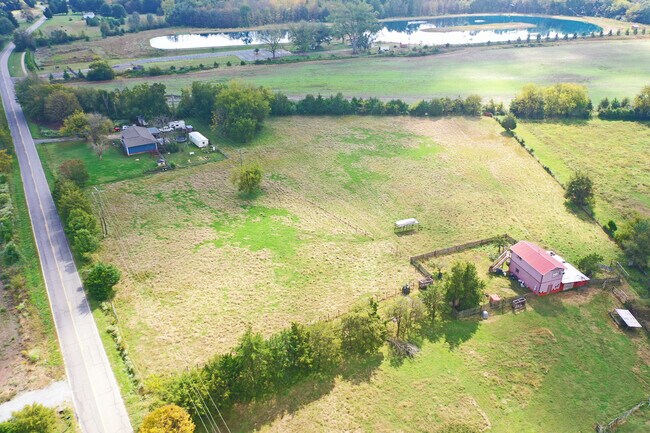
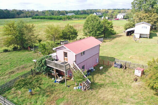
169 Rambo Rd E
5280000011
Property Surveyed For John Kondilis
Residentialnec
4.50 AC / E RAMBO RD
X
York
45023C0100C
South Carolina
2025
4.50 AC
2025
York County
061302
Charlotte
480 SF
Charlotte-Concord-Gastonia, NC-SC
DEMOGRAPHICS near 169 Rambo Rd E
1 mile
3 mile
5 mile
2024 Total Population
498
7,929
33,373
2029 Population
563
8,907
37,668
Pop Growth 2024-2029
+ 13.05%
+ 12.33%
+ 12.87%
Average Age
40
39
40
2024 Total Households
175
2,906
12,966
HH Growth 2024-2029
+ 13.14%
+ 12.66%
+ 13.30%
Median Household Inc
$65,089
$68,363
$52,991
Avg Household Size
2.70
2.70
2.50
2024 Avg HH Vehicles
2.00
2.00
2.00
Median Home Value
$214,062
$215,295
$197,214
Median Year Built
1995
1996
1990
Nearby Places
Map Layers
Map Styles
 Street
 Aerial
Transit
 Traffic
 Biking
Places
Listings with unknown addresses are not visible on the map
- Restaurants
- Banks
- Shops
- Fitness
- Groceries
PUBLIC TRANSPORTATION
AIRPORT
Charlotte/Douglas International
Drive
Walk
Distance
Charlotte/Douglas International
48 min
30.6 mi
Freight Ports
North Charleston Terminal
Drive
Walk
Distance
North Charleston Terminal
201 min
177.4 mi
SALE & LEASE HISTORY
LISTING DATE
SALE/LEASE

Oct 28, 2020
For Sale
Nearby Properties
Address
Land Use
TOTAL SIZE
Lot Size
Zoning
Address
Land Use
TOTAL SIZE
Lot Size
Zoning
144.70 AC
Address
Land Use
TOTAL SIZE
Lot Size
Zoning
118.42 AC
OI
Address
Land Use
TOTAL SIZE
Lot Size
Zoning
107.91 AC
RUD
Address
Land Use
TOTAL SIZE
Lot Size
Zoning
49.77 AC
PUD
Address
Land Use
TOTAL SIZE
Lot Size
Zoning
47.33 AC
OI
Address
Land Use
TOTAL SIZE
Lot Size
Zoning
44.26 AC
OI
Address
Land Use
TOTAL SIZE
Lot Size
Zoning
2,969 SF
1 AC
RCI
Address
Land Use
TOTAL SIZE
Lot Size
Zoning
2,709 SF
1 AC
SF3
Address
Land Use
TOTAL SIZE
Lot Size
Zoning
3,567 SF
0.14 AC
Address
Land Use
TOTAL SIZE
Lot Size
Zoning
2,995 SF
1 AC
Address
Land Use
TOTAL SIZE
Lot Size
Zoning
3,594 SF
1 AC
PUD
Address
Land Use
TOTAL SIZE
Lot Size
Zoning
3,061 SF
1 AC
PD
Address
Land Use
TOTAL SIZE
Lot Size
Zoning
4,080 SF
1 AC
PD
Address
Land Use
TOTAL SIZE
Lot Size
Zoning
2,530 SF
1 AC
Address
Land Use
TOTAL SIZE
Lot Size
Zoning
2,180 SF
1 AC
RCI
Address
Land Use
TOTAL SIZE
Lot Size
Zoning
4,200 SF
4.30 AC
RUD
Address
Land Use
TOTAL SIZE
Lot Size
Zoning
2,030 SF
1 AC
RCI
Address
Land Use
TOTAL SIZE
Lot Size
Zoning
1,605 SF
AGC
Address
Land Use
TOTAL SIZE
Lot Size
Zoning
2,538 SF
0.22 AC
SF5
Address
Land Use
TOTAL SIZE
Lot Size
Zoning
2,436 SF
1 AC
PUD
Address
Land Use
TOTAL SIZE
Lot Size
Zoning
2,199 SF
1 AC
PUD
Address
Land Use
TOTAL SIZE
Lot Size
Zoning
2,532 SF
1 AC
Address
Land Use
TOTAL SIZE
Lot Size
Zoning
2,171 SF
1 AC
SF3
Address
Land Use
TOTAL SIZE
Lot Size
Zoning
2,154 SF
1 AC
Address
Land Use
TOTAL SIZE
Lot Size
Zoning
2,980 SF
1.95 AC
RDI
Address
Land Use
TOTAL SIZE
Lot Size
Zoning
2,208 SF
0.26 AC
Address
Land Use
TOTAL SIZE
Lot Size
Zoning
25 AC
IH
Address
Land Use
TOTAL SIZE
Lot Size
Zoning
1,736 SF
2 AC
RCI
Address
Land Use
TOTAL SIZE
Lot Size
Zoning
2,164 SF
0.17 AC
SF5
The World's #1 Commercial Real Estate Marketplace
Connect with us
© 2026 CoStar Group
The information above has been obtained from sources believed reliable. While we do not doubt its accuracy we have not verified it and make no guarantee, warranty or representation about it. It is your responsibility to independently confirm its accuracy and completeness. Any projections, opinions, assumptions, or estimates used are for example only and do not represent the current or future performance of the property. The value of this transaction to you depends on tax and other factors which should be evaluated by your tax, financial, and legal advisors. You and your advisors should conduct a careful, independent investigation of the property to determine to your satisfaction the suitability of the property for your needs.