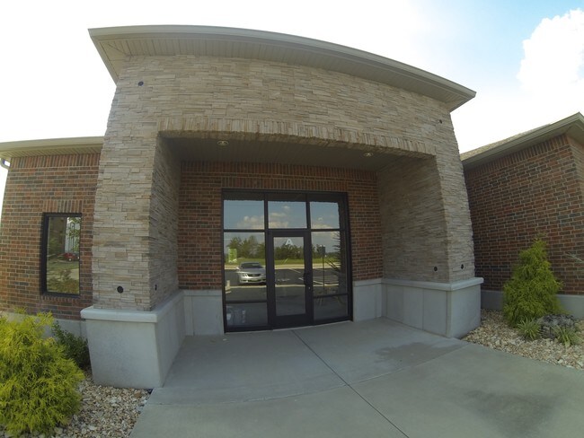
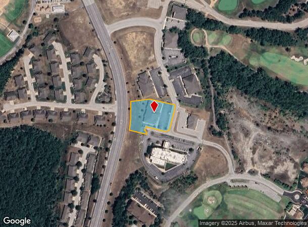
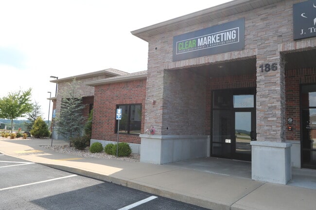
Property Record
169 S Payne Stewart Dr, Branson, MO 65616
NEARBY LISTINGS FOR SALE OR LEASE
Property Detail
169 S Payne Stewart Dr
Branson, MO
Branson Hills Development - Ph 2 Amd Pla
08-4.0-20-000-000-063.063
BRANSON HILLS DEVELOPMENT - PH 2 AMD PLAT LT 63 CI
Commercialnec
Taney
X
Missouri
29213C0161E
63
2024
1.09 AC
2025
Branson
480206
Other Market Areas
9,764 SF
DEMOGRAPHICS near 169 S Payne Stewart Dr
1 Mile
3 Mile
5 Mile
2024 Total Population
2,716
12,935
32,864
2029 Population
2,775
13,118
33,603
Pop Growth 2024-2029
+ 2.17%
+ 1.41%
+ 2.25%
Average Age
43
41
40
2024 Total Households
1,183
5,288
12,957
HH Growth 2024-2029
+ 1.94%
+ 1.42%
+ 2.25%
Median Household Inc
$53,454
$54,989
$52,060
Avg Household Size
2.20
2.30
2.30
2024 Avg HH Vehicles
2.00
2.00
2.00
Median Home Value
$284,403
$208,000
$179,260
Median Year Built
2000
1996
1995
Nearby Places
Map Layers
Map Styles
 Street
 Aerial
- Restaurants
- Banks
- Shops
- Fitness
- Groceries
SALE & LEASE HISTORY
LISTING DATE
SALE/LEASE

Sep 25, 2016
For Lease
Nearby Properties
Address
Land Use
TOTAL SIZE
Lot Size
Zoning
Address
Land Use
TOTAL SIZE
Lot Size
Zoning
50,417 SF
17.43 AC
Address
Land Use
TOTAL SIZE
Lot Size
Zoning
66,272 SF
7.83 AC
Address
Land Use
TOTAL SIZE
Lot Size
Zoning
140,093 SF
8.37 AC
Address
Land Use
TOTAL SIZE
Lot Size
Zoning
59,939 SF
15.76 AC
Address
Land Use
TOTAL SIZE
Lot Size
Zoning
Address
Land Use
TOTAL SIZE
Lot Size
Zoning
123,377 SF
13.05 AC
Address
Land Use
TOTAL SIZE
Lot Size
Zoning
63,890 SF
14.45 AC
Address
Land Use
TOTAL SIZE
Lot Size
Zoning
104,868 SF
13.61 AC
Address
Land Use
TOTAL SIZE
Lot Size
Zoning
19,872 SF
2.97 AC
Address
Land Use
TOTAL SIZE
Lot Size
Zoning
167.53 AC
Address
Land Use
TOTAL SIZE
Lot Size
Zoning
25,760 SF
6.47 AC
Address
Land Use
TOTAL SIZE
Lot Size
Zoning
24,176 SF
10.28 AC
Address
Land Use
TOTAL SIZE
Lot Size
Zoning
48,182 SF
15 AC
Address
Land Use
TOTAL SIZE
Lot Size
Zoning
51,842 SF
3.48 AC
Address
Land Use
TOTAL SIZE
Lot Size
Zoning
44,871 SF
4.57 AC
Address
Land Use
TOTAL SIZE
Lot Size
Zoning
18,308 SF
2.59 AC
Address
Land Use
TOTAL SIZE
Lot Size
Zoning
1,804,046 SF
23.86 AC
Address
Land Use
TOTAL SIZE
Lot Size
Zoning
34,856 SF
15.68 AC
Address
Land Use
TOTAL SIZE
Lot Size
Zoning
15,605 SF
3.13 AC
Address
Land Use
TOTAL SIZE
Lot Size
Zoning
10,860 SF
0.29 AC
Address
Land Use
TOTAL SIZE
Lot Size
Zoning
33,184 SF
16.14 AC
Address
Land Use
TOTAL SIZE
Lot Size
Zoning
71,120 SF
43.42 AC
Address
Land Use
TOTAL SIZE
Lot Size
Zoning
68,610 SF
5.04 AC
Address
Land Use
TOTAL SIZE
Lot Size
Zoning
24,578 SF
16.15 AC
Address
Land Use
TOTAL SIZE
Lot Size
Zoning
118,200 SF
4.20 AC
Address
Land Use
TOTAL SIZE
Lot Size
Zoning
46,797 SF
1.67 AC
Address
Land Use
TOTAL SIZE
Lot Size
Zoning
15,915 SF
4.47 AC
Address
Land Use
TOTAL SIZE
Lot Size
Zoning
57,263 SF
6.06 AC
Address
Land Use
TOTAL SIZE
Lot Size
Zoning
The World's #1 Commercial Real Estate Marketplace
Connect with us
© 2025 CoStar Group
The information above has been obtained from sources believed reliable. While we do not doubt its accuracy we have not verified it and make no guarantee, warranty or representation about it. It is your responsibility to independently confirm its accuracy and completeness. Any projections, opinions, assumptions, or estimates used are for example only and do not represent the current or future performance of the property. The value of this transaction to you depends on tax and other factors which should be evaluated by your tax, financial, and legal advisors. You and your advisors should conduct a careful, independent investigation of the property to determine to your satisfaction the suitability of the property for your needs.