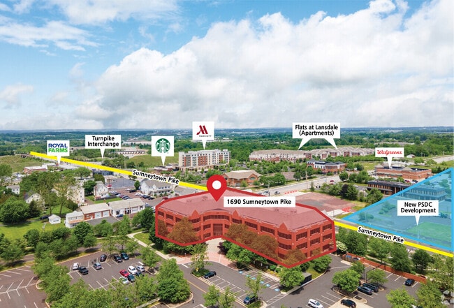
Property Record
1690 Sumneytown Pike, Lansdale, PA 19446


Current Lease Availabilities
NEARBY LISTINGS FOR SALE OR LEASE
Property Detail
1690 Sumneytown Pike
Philadelphia-Camden-Wilmington, PA-NJ-DE-MD
Kulpsville Bus Campus
53-00-08256-016
UNIT 4 77500 SF
Officebuilding
Montgomery
X
Pennsylvania
42091C0252G
75
2024
1.78 AC
2025
West Montgomery County
206905
Philadelphia
77,700 SF
DEMOGRAPHICS near 1690 Sumneytown Pike
1 Mile
3 Mile
5 Mile
2024 Total Population
7,546
51,789
131,297
2029 Population
7,587
52,491
133,325
Pop Growth 2024-2029
+ 0.54%
+ 1.36%
+ 1.54%
Average Age
44
43
43
2024 Total Households
3,066
20,437
50,511
HH Growth 2024-2029
+ 0.49%
+ 1.26%
+ 1.47%
Median Household Inc
$105,047
$105,067
$105,716
Avg Household Size
2.40
2.50
2.50
2024 Avg HH Vehicles
2.00
2.00
2.00
Median Home Value
$325,616
$384,094
$385,669
Median Year Built
1985
1981
1979
Nearby Places
Map Layers
Map Styles
 Street
 Aerial
- Restaurants
- Banks
- Shops
- Fitness
- Groceries
PUBLIC TRANSPORTATION
COMMUTER RAIL
Lansdale (R5 - Southeastern Pennsylvania Transportation Authority Regional Rail (SEPTA Regional Rail))
DRIVE
WALK
Distance
Lansdale (R5 - Southeastern Pennsylvania Transportation Authority Regional Rail (SEPTA Regional Rail))
9 min
4.0 mi
North Wales (R5 - Southeastern Pennsylvania Transportation Authority Regional Rail (SEPTA Regional Rail))
DRIVE
WALK
Distance
North Wales (R5 - Southeastern Pennsylvania Transportation Authority Regional Rail (SEPTA Regional Rail))
10 min
4.2 mi
AIRPORT
Philadelphia International
DRIVE
WALK
Distance
Philadelphia International
52 min
37.2 mi
Lehigh Valley International
DRIVE
WALK
Distance
Lehigh Valley International
50 min
38.3 mi
Trenton Mercer
DRIVE
WALK
Distance
Trenton Mercer
58 min
45.7 mi
Nearby Properties
Address
Land Use
TOTAL SIZE
Lot Size
Zoning
Address
Land Use
TOTAL SIZE
Lot Size
Zoning
7,622,512 SF
315.44 AC
LI
Address
Land Use
TOTAL SIZE
Lot Size
Zoning
720,767 SF
118.21 AC
AGR
Address
Land Use
TOTAL SIZE
Lot Size
Zoning
519,907 SF
91.44 AC
R125
Address
Land Use
TOTAL SIZE
Lot Size
Zoning
629,336 SF
31.74 AC
IN
Address
Land Use
TOTAL SIZE
Lot Size
Zoning
444,426 SF
30 AC
GA
Address
Land Use
TOTAL SIZE
Lot Size
Zoning
454,126 SF
37.18 AC
MRC
Address
Land Use
TOTAL SIZE
Lot Size
Zoning
253,741 SF
9.09 AC
VO
Address
Land Use
TOTAL SIZE
Lot Size
Zoning
832,830 SF
53.72 AC
LI
Address
Land Use
TOTAL SIZE
Lot Size
Zoning
253,915 SF
17.78 AC
GA
Address
Land Use
TOTAL SIZE
Lot Size
Zoning
219,869 SF
41.98 AC
LI
Address
Land Use
TOTAL SIZE
Lot Size
Zoning
211,561 SF
38.80 AC
LI
Address
Land Use
TOTAL SIZE
Lot Size
Zoning
225,154 SF
6.38 AC
B
Address
Land Use
TOTAL SIZE
Lot Size
Zoning
373,104 SF
31.94 AC
LI
Address
Land Use
TOTAL SIZE
Lot Size
Zoning
170,351 SF
71.70 AC
IN
Address
Land Use
TOTAL SIZE
Lot Size
Zoning
179,930 SF
16 AC
IN
Address
Land Use
TOTAL SIZE
Lot Size
Zoning
220,124 SF
33.16 AC
SC
Address
Land Use
TOTAL SIZE
Lot Size
Zoning
168,557 SF
44.77 AC
RA1
Address
Land Use
TOTAL SIZE
Lot Size
Zoning
216,017 SF
16 AC
GA
Address
Land Use
TOTAL SIZE
Lot Size
Zoning
156,694 SF
18.82 AC
C
Address
Land Use
TOTAL SIZE
Lot Size
Zoning
207,306 SF
14.50 AC
GA
Address
Land Use
TOTAL SIZE
Lot Size
Zoning
125,704 SF
25 AC
R2
Address
Land Use
TOTAL SIZE
Lot Size
Zoning
87,170 SF
10.23 AC
RA
Address
Land Use
TOTAL SIZE
Lot Size
Zoning
98,782 SF
5.09 AC
BC
Address
Land Use
TOTAL SIZE
Lot Size
Zoning
233,964 SF
8.05 AC
B
Address
Land Use
TOTAL SIZE
Lot Size
Zoning
68,442 SF
12.22 AC
AGR
Address
Land Use
TOTAL SIZE
Lot Size
Zoning
17,364 SF
31.92 AC
LI
Address
Land Use
TOTAL SIZE
Lot Size
Zoning
197,233 SF
15.66 AC
LI
Address
Land Use
TOTAL SIZE
Lot Size
Zoning
90,217 SF
19 AC
R1
Address
Land Use
TOTAL SIZE
Lot Size
Zoning
648,406 SF
43.51 AC
OC
Address
Land Use
TOTAL SIZE
Lot Size
Zoning
122,873 SF
11.17 AC
R125
The World's #1 Commercial Real Estate Marketplace
Connect with us
© 2026 CoStar Group
The information above has been obtained from sources believed reliable. While we do not doubt its accuracy we have not verified it and make no guarantee, warranty or representation about it. It is your responsibility to independently confirm its accuracy and completeness. Any projections, opinions, assumptions, or estimates used are for example only and do not represent the current or future performance of the property. The value of this transaction to you depends on tax and other factors which should be evaluated by your tax, financial, and legal advisors. You and your advisors should conduct a careful, independent investigation of the property to determine to your satisfaction the suitability of the property for your needs.