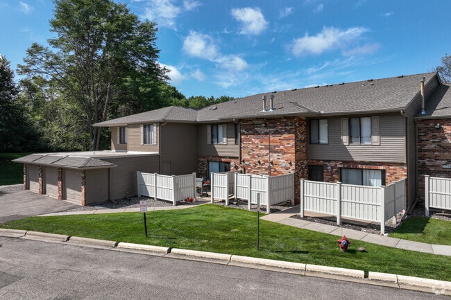
Property Record
16900 Saddlewood Trl, Minnetonka, MN 55345

NEARBY LISTINGS FOR SALE OR LEASE
-
-
View all Minnetonka listings for sale on LoopNet.com
Property Detail
16900 Saddlewood Trl
Minneapolis-St. Paul-Bloomington, MN-WI
Saddlewood Park
29-117-22-21-0047
LOT 001 BLOCK 002 B SADDLEWOOD PARK IRREGULAR
Apartment
Hennepin
X
Minnesota
27053C0336F
1
2024
2.70 AC
2024
West Minnetonka
026201
Minneapolis/St Paul
28,134 SF
DEMOGRAPHICS near 16900 Saddlewood Trl
1 Mile
3 Mile
5 Mile
2024 Total Population
5,776
43,523
129,261
2029 Population
5,641
42,750
128,529
Pop Growth 2024-2029
(2.34%)
(1.78%)
(0.57%)
Average Age
43
43
43
2024 Total Households
2,192
16,604
54,656
HH Growth 2024-2029
(2.51%)
(1.99%)
(0.69%)
Median Household Inc
$132,692
$131,951
$107,894
Avg Household Size
2.60
2.60
2.30
2024 Avg HH Vehicles
2.00
2.00
2.00
Median Home Value
$419,963
$451,155
$442,581
Median Year Built
1967
1975
1981
Nearby Places
Map Layers
Map Styles
 Street
 Aerial
- Restaurants
- Banks
- Shops
- Fitness
- Groceries
PUBLIC TRANSPORTATION
AIRPORT
Minneapolis-St Paul International/Wold-Chamberlain
DRIVE
WALK
Distance
Minneapolis-St Paul International/Wold-Chamberlain
28 min
19.5 mi
Freight Ports
Port Milwaukee
DRIVE
WALK
Distance
Port Milwaukee
396 min
353.2 mi
Nearby Properties
Address
Land Use
TOTAL SIZE
Lot Size
Zoning
Address
Land Use
TOTAL SIZE
Lot Size
Zoning
171,900 SF
39.17 AC
B1
Address
Land Use
TOTAL SIZE
Lot Size
Zoning
46,726 SF
2.65 AC
PUD
Address
Land Use
TOTAL SIZE
Lot Size
Zoning
20.18 AC
RM65
Address
Land Use
TOTAL SIZE
Lot Size
Zoning
2,676 SF
3.17 AC
PUD
Address
Land Use
TOTAL SIZE
Lot Size
Zoning
7.06 AC
PUD
Address
Land Use
TOTAL SIZE
Lot Size
Zoning
49,925 SF
18.37 AC
B1
Address
Land Use
TOTAL SIZE
Lot Size
Zoning
7,209 SF
2.53 AC
B1
Address
Land Use
TOTAL SIZE
Lot Size
Zoning
177,644 SF
10.49 AC
I1
Address
Land Use
TOTAL SIZE
Lot Size
Zoning
29,091 SF
34.94 AC
PUD
Address
Land Use
TOTAL SIZE
Lot Size
Zoning
7.82 AC
R4
Address
Land Use
TOTAL SIZE
Lot Size
Zoning
17.67 AC
R4
Address
Land Use
TOTAL SIZE
Lot Size
Zoning
9.29 AC
R4
Address
Land Use
TOTAL SIZE
Lot Size
Zoning
88,948 SF
10.14 AC
B2
Address
Land Use
TOTAL SIZE
Lot Size
Zoning
14.04 AC
R4
Address
Land Use
TOTAL SIZE
Lot Size
Zoning
28,208 SF
6.15 AC
PUD
Address
Land Use
TOTAL SIZE
Lot Size
Zoning
152,823 SF
12.14 AC
I1
Address
Land Use
TOTAL SIZE
Lot Size
Zoning
38,825 SF
5.38 AC
B3
Address
Land Use
TOTAL SIZE
Lot Size
Zoning
47,485 SF
2.19 AC
PUD
Address
Land Use
TOTAL SIZE
Lot Size
Zoning
1,000 SF
14 AC
Address
Land Use
TOTAL SIZE
Lot Size
Zoning
120,709 SF
16.47 AC
I1
Address
Land Use
TOTAL SIZE
Lot Size
Zoning
15,504 SF
5.80 AC
I1
Address
Land Use
TOTAL SIZE
Lot Size
Zoning
12,993 SF
2.22 AC
R5
Address
Land Use
TOTAL SIZE
Lot Size
Zoning
Address
Land Use
TOTAL SIZE
Lot Size
Zoning
99,423 SF
8.13 AC
I1
Address
Land Use
TOTAL SIZE
Lot Size
Zoning
37,200 SF
6.21 AC
PUD
Address
Land Use
TOTAL SIZE
Lot Size
Zoning
123,472 SF
9.07 AC
B2
Address
Land Use
TOTAL SIZE
Lot Size
Zoning
104,969 SF
8.09 AC
I1
Address
Land Use
TOTAL SIZE
Lot Size
Zoning
74,250 SF
5.93 AC
PUD
Address
Land Use
TOTAL SIZE
Lot Size
Zoning
72,936 SF
8.68 AC
I-2
Address
Land Use
TOTAL SIZE
Lot Size
Zoning
3.55 AC
The World's #1 Commercial Real Estate Marketplace
Connect with us
© 2026 CoStar Group
The information above has been obtained from sources believed reliable. While we do not doubt its accuracy we have not verified it and make no guarantee, warranty or representation about it. It is your responsibility to independently confirm its accuracy and completeness. Any projections, opinions, assumptions, or estimates used are for example only and do not represent the current or future performance of the property. The value of this transaction to you depends on tax and other factors which should be evaluated by your tax, financial, and legal advisors. You and your advisors should conduct a careful, independent investigation of the property to determine to your satisfaction the suitability of the property for your needs.