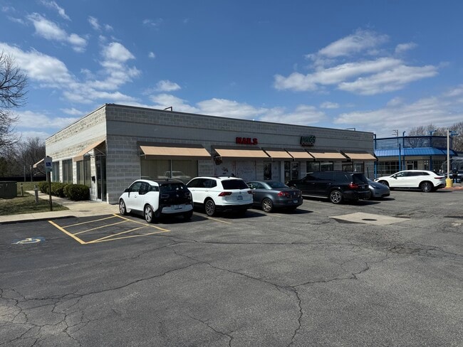
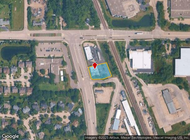
Property Record
1691 Weiland Rd, Buffalo Grove, IL 60089

Current Lease Availabilities
NEARBY LISTINGS FOR SALE OR LEASE
Property Detail
1691 Weiland Rd
Chicago-Naperville-Elgin, IL-IN-WI
Old Weiland Sub
15-28-217-004
OLD WEILAND SUB; LOT 2 (EX BEG AT NW COR NE 10, SE 72.12; SLY ALG A CURV 36.45 TO SLY LN SD LT, NWLY ALG CURV 26.84 , NW 84.32 TO POB)
Commercialbuilding
Lake
X
Illinois
17097C0262K
2
2023
0.55 AC
2024
Central North
864520
Chicago
DEMOGRAPHICS near 1691 Weiland Rd
1 Mile
3 Mile
5 Mile
2024 Total Population
7,201
68,830
203,698
2029 Population
7,167
67,894
200,410
Pop Growth 2024-2029
(0.47%)
(1.36%)
(1.61%)
Average Age
40
42
41
2024 Total Households
2,561
25,725
76,816
HH Growth 2024-2029
(0.62%)
(1.48%)
(1.80%)
Median Household Inc
$160,849
$117,198
$101,439
Avg Household Size
2.80
2.60
2.60
2024 Avg HH Vehicles
2.00
2.00
2.00
Median Home Value
$481,057
$384,846
$376,105
Median Year Built
1988
1983
1981
Nearby Places
Map Layers
Map Styles
 Street
 Aerial
- Restaurants
- Banks
- Shops
- Fitness
- Groceries
PUBLIC TRANSPORTATION
COMMUTER RAIL
Buffalo Grove Station (North Central Service - Northeast Illinois Regional Commuter Railroad (Metra))
DRIVE
WALK
Distance
Buffalo Grove Station (North Central Service - Northeast Illinois Regional Commuter Railroad (Metra))
3 min
1.5 mi
Prairie View Station (North Central Service - Northeast Illinois Regional Commuter Railroad (Metra))
DRIVE
WALK
Distance
Prairie View Station (North Central Service - Northeast Illinois Regional Commuter Railroad (Metra))
4 min
2.0 mi
AIRPORT
Chicago O'Hare International
DRIVE
WALK
Distance
Chicago O'Hare International
29 min
18.6 mi
Chicago Midway International
DRIVE
WALK
Distance
Chicago Midway International
55 min
32.0 mi
Freight Ports
Port Milwaukee
DRIVE
WALK
Distance
Port Milwaukee
77 min
63.8 mi
Nearby Properties
Address
Land Use
TOTAL SIZE
Lot Size
Zoning
Address
Land Use
TOTAL SIZE
Lot Size
Zoning
28.14 AC
Address
Land Use
TOTAL SIZE
Lot Size
Zoning
65.17 AC
Address
Land Use
TOTAL SIZE
Lot Size
Zoning
Address
Land Use
TOTAL SIZE
Lot Size
Zoning
24.64 AC
Address
Land Use
TOTAL SIZE
Lot Size
Zoning
18.40 AC
Address
Land Use
TOTAL SIZE
Lot Size
Zoning
8.21 AC
Address
Land Use
TOTAL SIZE
Lot Size
Zoning
Address
Land Use
TOTAL SIZE
Lot Size
Zoning
14.26 AC
Address
Land Use
TOTAL SIZE
Lot Size
Zoning
12.58 AC
Address
Land Use
TOTAL SIZE
Lot Size
Zoning
Address
Land Use
TOTAL SIZE
Lot Size
Zoning
16.20 AC
Address
Land Use
TOTAL SIZE
Lot Size
Zoning
Address
Land Use
TOTAL SIZE
Lot Size
Zoning
Address
Land Use
TOTAL SIZE
Lot Size
Zoning
13.53 AC
Address
Land Use
TOTAL SIZE
Lot Size
Zoning
22.16 AC
Address
Land Use
TOTAL SIZE
Lot Size
Zoning
20.03 AC
Address
Land Use
TOTAL SIZE
Lot Size
Zoning
362,944 SF
12.74 AC
Address
Land Use
TOTAL SIZE
Lot Size
Zoning
Address
Land Use
TOTAL SIZE
Lot Size
Zoning
840 SF
2.37 AC
Address
Land Use
TOTAL SIZE
Lot Size
Zoning
Address
Land Use
TOTAL SIZE
Lot Size
Zoning
20.95 AC
Address
Land Use
TOTAL SIZE
Lot Size
Zoning
10.07 AC
Address
Land Use
TOTAL SIZE
Lot Size
Zoning
Address
Land Use
TOTAL SIZE
Lot Size
Zoning
15.37 AC
Address
Land Use
TOTAL SIZE
Lot Size
Zoning
Address
Land Use
TOTAL SIZE
Lot Size
Zoning
29.76 AC
Address
Land Use
TOTAL SIZE
Lot Size
Zoning
9.08 AC
Address
Land Use
TOTAL SIZE
Lot Size
Zoning
10.27 AC
Address
Land Use
TOTAL SIZE
Lot Size
Zoning
Address
Land Use
TOTAL SIZE
Lot Size
Zoning
The World's #1 Commercial Real Estate Marketplace
Connect with us
© 2025 CoStar Group
The information above has been obtained from sources believed reliable. While we do not doubt its accuracy we have not verified it and make no guarantee, warranty or representation about it. It is your responsibility to independently confirm its accuracy and completeness. Any projections, opinions, assumptions, or estimates used are for example only and do not represent the current or future performance of the property. The value of this transaction to you depends on tax and other factors which should be evaluated by your tax, financial, and legal advisors. You and your advisors should conduct a careful, independent investigation of the property to determine to your satisfaction the suitability of the property for your needs.