Property Record
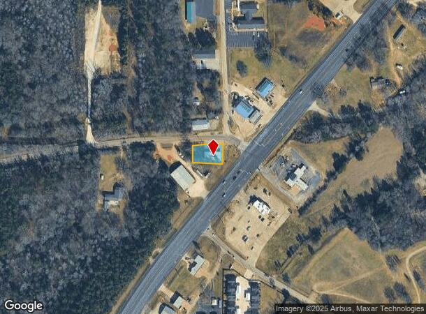
16912 State Highway 155 S, Flint, TX 75762

NEARBY LISTINGS FOR SALE OR LEASE
-
-
View all Flint listings for sale on LoopNet.com
Property Detail
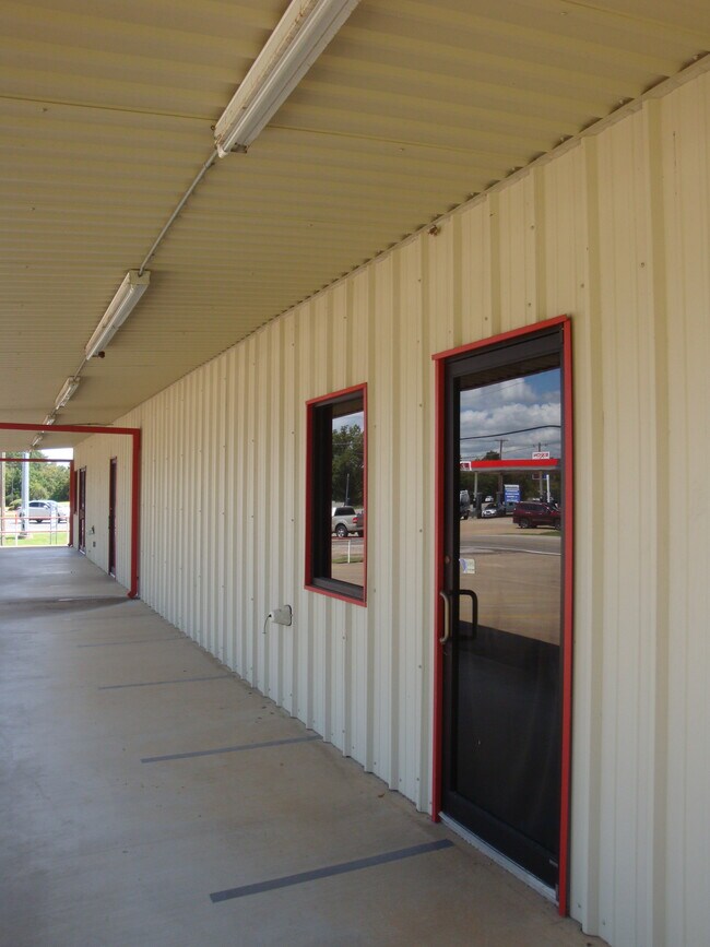
16912 State Highway 155 S
1-00000-0018-26-020000
A0018 T Quevado
Storebuilding
ABST A0018 T QUEVADOTRACT 20 S26
X
Smith
48073C0025D
Texas
2024
0.29 AC
2025
Noonday
001913
Other Market Areas
2,560 SF
Tyler, TX
DEMOGRAPHICS near 16912 State Highway 155 S
1 mile
3 mile
5 mile
2024 Total Population
752
5,343
22,867
2029 Population
818
5,821
24,980
Pop Growth 2024-2029
+ 8.78%
+ 8.95%
+ 9.24%
Average Age
40
41
41
2024 Total Households
281
2,022
8,683
HH Growth 2024-2029
+ 8.19%
+ 8.41%
+ 8.80%
Median Household Inc
$95,651
$82,525
$77,878
Avg Household Size
2.60
2.60
2.60
2024 Avg HH Vehicles
2.00
2.00
2.00
Median Home Value
$251,260
$251,151
$273,219
Median Year Built
2001
1997
2000
Nearby Places
Map Layers
Map Styles
 Street
 Aerial
Transit
 Traffic
 Biking
Places
Listings with unknown addresses are not visible on the map
- Restaurants
- Banks
- Shops
- Fitness
- Groceries
PUBLIC TRANSPORTATION
AIRPORT
Tyler Pounds Regional
Drive
Walk
Distance
Tyler Pounds Regional
19 min
12.3 mi
Freight Ports
Port of Shreveport
Drive
Walk
Distance
Port of Shreveport
134 min
118.7 mi
SALE & LEASE HISTORY
LISTING DATE
SALE/LEASE

Sep 10, 2020
For Sale
Nearby Properties
Address
Land Use
TOTAL SIZE
Lot Size
Zoning
Address
Land Use
TOTAL SIZE
Lot Size
Zoning
21.31 AC
Address
Land Use
TOTAL SIZE
Lot Size
Zoning
23,968 SF
75.85 AC
Address
Land Use
TOTAL SIZE
Lot Size
Zoning
57,918 SF
16.72 AC
Address
Land Use
TOTAL SIZE
Lot Size
Zoning
2,820 SF
10 AC
Address
Land Use
TOTAL SIZE
Lot Size
Zoning
97.48 AC
Address
Land Use
TOTAL SIZE
Lot Size
Zoning
9,050 SF
6 AC
Address
Land Use
TOTAL SIZE
Lot Size
Zoning
36,000 SF
4.33 AC
Address
Land Use
TOTAL SIZE
Lot Size
Zoning
29,550 SF
4.70 AC
Address
Land Use
TOTAL SIZE
Lot Size
Zoning
37.35 AC
Address
Land Use
TOTAL SIZE
Lot Size
Zoning
26,848 SF
9.18 AC
Address
Land Use
TOTAL SIZE
Lot Size
Zoning
3,056 SF
5.15 AC
Address
Land Use
TOTAL SIZE
Lot Size
Zoning
3,056 SF
5.06 AC
Address
Land Use
TOTAL SIZE
Lot Size
Zoning
Address
Land Use
TOTAL SIZE
Lot Size
Zoning
4.95 AC
Address
Land Use
TOTAL SIZE
Lot Size
Zoning
5,000 SF
4.89 AC
Address
Land Use
TOTAL SIZE
Lot Size
Zoning
12,000 SF
2.95 AC
Address
Land Use
TOTAL SIZE
Lot Size
Zoning
868 SF
130.55 AC
Address
Land Use
TOTAL SIZE
Lot Size
Zoning
7,476 SF
3.91 AC
Address
Land Use
TOTAL SIZE
Lot Size
Zoning
72.92 AC
Address
Land Use
TOTAL SIZE
Lot Size
Zoning
12,600 SF
9.83 AC
Address
Land Use
TOTAL SIZE
Lot Size
Zoning
6,000 SF
3.80 AC
Address
Land Use
TOTAL SIZE
Lot Size
Zoning
3,600 SF
2.01 AC
Address
Land Use
TOTAL SIZE
Lot Size
Zoning
6,034 SF
3 AC
Address
Land Use
TOTAL SIZE
Lot Size
Zoning
5,193 SF
6 AC
Address
Land Use
TOTAL SIZE
Lot Size
Zoning
7,466 SF
0.50 AC
Address
Land Use
TOTAL SIZE
Lot Size
Zoning
Address
Land Use
TOTAL SIZE
Lot Size
Zoning
2,880 SF
18.43 AC
Address
Land Use
TOTAL SIZE
Lot Size
Zoning
5,000 SF
1 AC
Address
Land Use
TOTAL SIZE
Lot Size
Zoning
4,640 SF
2.58 AC
Address
Land Use
TOTAL SIZE
Lot Size
Zoning
The World's #1 Commercial Real Estate Marketplace
Connect with us
© 2026 CoStar Group
The information above has been obtained from sources believed reliable. While we do not doubt its accuracy we have not verified it and make no guarantee, warranty or representation about it. It is your responsibility to independently confirm its accuracy and completeness. Any projections, opinions, assumptions, or estimates used are for example only and do not represent the current or future performance of the property. The value of this transaction to you depends on tax and other factors which should be evaluated by your tax, financial, and legal advisors. You and your advisors should conduct a careful, independent investigation of the property to determine to your satisfaction the suitability of the property for your needs.