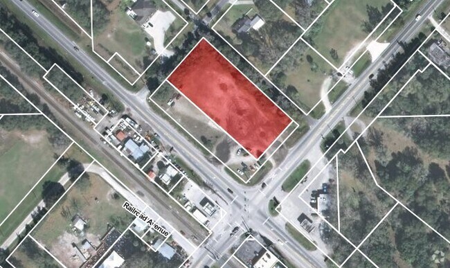
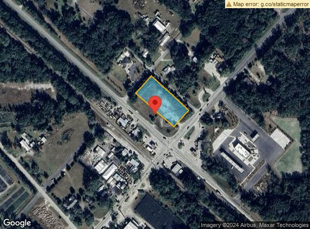
Property Record
1695 S Us Highway 17, Pierson, FL 32180
NEARBY LISTINGS FOR SALE OR LEASE
-
-
View all Pierson listings for sale on LoopNet.com
Property Detail
1695 S Us Highway 17
Deltona-Daytona Beach-Ormond Beach, FL
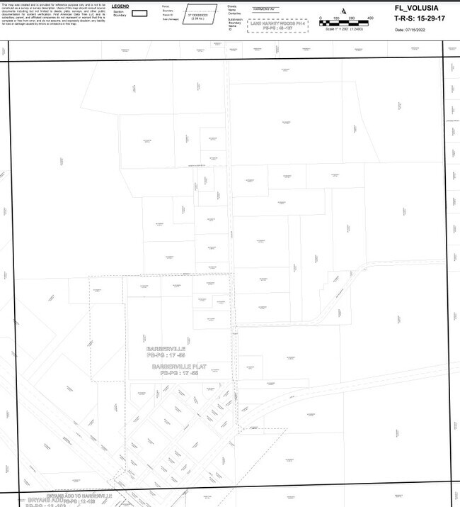
Barberville Mb
5917-01-11-0030
17 & 20-15-29 LOTS 3 THRU 6 BLK 1 BARBERVILLE MB 1 PG 161 MB 17 PG 55 EXC PART DESCRIBED AS FDOT PARCEL 134 SEC 79050 FP 410251-1 PER OR 7731 PG 2672 PER OR 4231 PGS 4709-4710 PER OR 5558 PGS 1425-1427 INC PER OR 5641 PG 0718 PER OR 5641 PG 0720 PER
Restaurantdrivein
Volusia
X
Florida
12127C0300H
3-6
2025
1.20 AC
2026
NW Volusia County
090101
Deltona/Daytona Beach
1,730 SF
DEMOGRAPHICS near 1695 S Us Highway 17
1 Mile
3 Mile
5 Mile
2024 Total Population
145
956
3,205
2029 Population
159
1,050
3,518
Pop Growth 2024-2029
+ 9.66%
+ 9.83%
+ 9.77%
Average Age
44
44
43
2024 Total Households
57
370
1,176
HH Growth 2024-2029
+ 10.53%
+ 9.73%
+ 9.86%
Median Household Inc
$66,250
$65,755
$68,035
Avg Household Size
2.50
2.50
2.60
2024 Avg HH Vehicles
2.00
2.00
2.00
Median Home Value
$279,166
$277,999
$280,444
Median Year Built
1979
1979
1981
Nearby Places
Map Layers
Map Styles
 Street
 Aerial
- Restaurants
- Banks
- Shops
- Fitness
- Groceries
PUBLIC TRANSPORTATION
AIRPORT
Daytona Beach International
DRIVE
WALK
Distance
Daytona Beach International
40 min
28.5 mi
Freight Ports
Port Canaveral
DRIVE
WALK
Distance
Port Canaveral
112 min
90.7 mi
Nearby Properties
Address
Land Use
TOTAL SIZE
Lot Size
Zoning
Address
Land Use
TOTAL SIZE
Lot Size
Zoning
5,436 SF
8.97 AC
01B4
Address
Land Use
TOTAL SIZE
Lot Size
Zoning
463 AC
C
Address
Land Use
TOTAL SIZE
Lot Size
Zoning
31,675 SF
168 AC
A1
Address
Land Use
TOTAL SIZE
Lot Size
Zoning
18,440 SF
15.90 AC
A1
Address
Land Use
TOTAL SIZE
Lot Size
Zoning
Address
Land Use
TOTAL SIZE
Lot Size
Zoning
324 AC
C
Address
Land Use
TOTAL SIZE
Lot Size
Zoning
29,322 SF
22.70 AC
R4
Address
Land Use
TOTAL SIZE
Lot Size
Zoning
657.69 AC
FR4
Address
Land Use
TOTAL SIZE
Lot Size
Zoning
5,121 SF
85.04 AC
RC
Address
Land Use
TOTAL SIZE
Lot Size
Zoning
584.38 AC
RC
Address
Land Use
TOTAL SIZE
Lot Size
Zoning
581.53 AC
FR
Address
Land Use
TOTAL SIZE
Lot Size
Zoning
36,556 SF
3.50 AC
A3
Address
Land Use
TOTAL SIZE
Lot Size
Zoning
3,910 SF
33.31 AC
A1
Address
Land Use
TOTAL SIZE
Lot Size
Zoning
662.31 AC
FR4
Address
Land Use
TOTAL SIZE
Lot Size
Zoning
10,674 SF
2 AC
01R4
Address
Land Use
TOTAL SIZE
Lot Size
Zoning
147 AC
C
Address
Land Use
TOTAL SIZE
Lot Size
Zoning
3,688 SF
21.61 AC
01A1
Address
Land Use
TOTAL SIZE
Lot Size
Zoning
409.45 AC
C
Address
Land Use
TOTAL SIZE
Lot Size
Zoning
136 AC
C
Address
Land Use
TOTAL SIZE
Lot Size
Zoning
437.42 AC
FR4
Address
Land Use
TOTAL SIZE
Lot Size
Zoning
6,450 SF
157.99 AC
A1
Address
Land Use
TOTAL SIZE
Lot Size
Zoning
3,962 SF
32.09 AC
Address
Land Use
TOTAL SIZE
Lot Size
Zoning
478.24 AC
FR4
Address
Land Use
TOTAL SIZE
Lot Size
Zoning
1,248 SF
48 AC
A1
Address
Land Use
TOTAL SIZE
Lot Size
Zoning
350.73 AC
FR4
Address
Land Use
TOTAL SIZE
Lot Size
Zoning
2,160 SF
174.59 AC
RC
Address
Land Use
TOTAL SIZE
Lot Size
Zoning
100.40 AC
01A3
Address
Land Use
TOTAL SIZE
Lot Size
Zoning
2,668 SF
30.21 AC
RC
Address
Land Use
TOTAL SIZE
Lot Size
Zoning
446.55 AC
FR4
The World's #1 Commercial Real Estate Marketplace
Connect with us
© 2026 CoStar Group
The information above has been obtained from sources believed reliable. While we do not doubt its accuracy we have not verified it and make no guarantee, warranty or representation about it. It is your responsibility to independently confirm its accuracy and completeness. Any projections, opinions, assumptions, or estimates used are for example only and do not represent the current or future performance of the property. The value of this transaction to you depends on tax and other factors which should be evaluated by your tax, financial, and legal advisors. You and your advisors should conduct a careful, independent investigation of the property to determine to your satisfaction the suitability of the property for your needs.