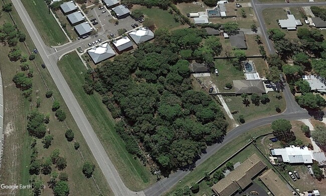
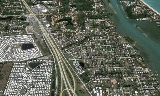
Property Record
1695 Settlers Dr, Nokomis, FL 34275
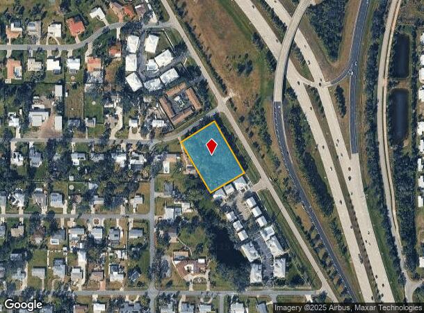
This Property Is For Sale
NEARBY LISTINGS FOR SALE OR LEASE
Property Detail
1695 Settlers Dr
North Port-Sarasota-Bradenton, FL
Hills Sub Jesse K
0164-12-0001
LOTS 1 2 & 3 BLK D JESSE K HILLS SUB
Residentialacreage
Sarasota
X
Florida
12115C0239G
1
2024
1.35 AC
2025
Sarasota
002714
Tampa/St Petersburg
DEMOGRAPHICS near 1695 Settlers Dr
1 Mile
3 Mile
5 Mile
2024 Total Population
4,894
26,443
63,460
2029 Population
5,699
30,986
74,450
Pop Growth 2024-2029
+ 16.45%
+ 17.18%
+ 17.32%
Average Age
58
56
60
2024 Total Households
2,546
13,098
32,909
HH Growth 2024-2029
+ 16.38%
+ 17.25%
+ 17.36%
Median Household Inc
$67,500
$72,505
$72,074
Avg Household Size
1.90
2.00
1.90
2024 Avg HH Vehicles
2.00
2.00
2.00
Median Home Value
$309,953
$366,707
$371,482
Median Year Built
1981
1984
1987
Nearby Places
Map Layers
Map Styles
 Street
 Aerial
- Restaurants
- Banks
- Shops
- Fitness
- Groceries
PUBLIC TRANSPORTATION
AIRPORT
Sarasota/Bradenton International
DRIVE
WALK
Distance
Sarasota/Bradenton International
37 min
19.5 mi
Punta Gorda
DRIVE
WALK
Distance
Punta Gorda
50 min
39.0 mi
Freight Ports
Port Manatee
DRIVE
WALK
Distance
Port Manatee
50 min
38.6 mi
Nearby Properties
Address
Land Use
TOTAL SIZE
Lot Size
Zoning
Address
Land Use
TOTAL SIZE
Lot Size
Zoning
308,834 SF
16 AC
PUD
Address
Land Use
TOTAL SIZE
Lot Size
Zoning
263,056 SF
25.54 AC
LW
Address
Land Use
TOTAL SIZE
Lot Size
Zoning
8,017 SF
56 AC
RMH
Address
Land Use
TOTAL SIZE
Lot Size
Zoning
181,657 SF
56.90 AC
GU
Address
Land Use
TOTAL SIZE
Lot Size
Zoning
8,562 SF
58.92 AC
RMH
Address
Land Use
TOTAL SIZE
Lot Size
Zoning
244,492 SF
73.19 AC
GU
Address
Land Use
TOTAL SIZE
Lot Size
Zoning
23,348 SF
77.03 AC
RMH
Address
Land Use
TOTAL SIZE
Lot Size
Zoning
190,485 SF
5.81 AC
NTG
Address
Land Use
TOTAL SIZE
Lot Size
Zoning
175,813 SF
10.09 AC
CG
Address
Land Use
TOTAL SIZE
Lot Size
Zoning
1,184 SF
90 AC
PUD
Address
Land Use
TOTAL SIZE
Lot Size
Zoning
133,773 SF
6.29 AC
OPI
Address
Land Use
TOTAL SIZE
Lot Size
Zoning
425,768 SF
18.41 AC
RMF2
Address
Land Use
TOTAL SIZE
Lot Size
Zoning
5,396 SF
33.59 AC
RMH
Address
Land Use
TOTAL SIZE
Lot Size
Zoning
12,552 SF
6.73 AC
RE2
Address
Land Use
TOTAL SIZE
Lot Size
Zoning
17,028 SF
3.57 AC
RE2
Address
Land Use
TOTAL SIZE
Lot Size
Zoning
12,263 SF
3.38 AC
RE2
Address
Land Use
TOTAL SIZE
Lot Size
Zoning
127,135 SF
12.37 AC
CG
Address
Land Use
TOTAL SIZE
Lot Size
Zoning
88,509 SF
12.03 AC
CG
Address
Land Use
TOTAL SIZE
Lot Size
Zoning
70,220 SF
9.31 AC
LW
Address
Land Use
TOTAL SIZE
Lot Size
Zoning
68,641 SF
6.40 AC
RTR
Address
Land Use
TOTAL SIZE
Lot Size
Zoning
112,788 SF
3.06 AC
CG
Address
Land Use
TOTAL SIZE
Lot Size
Zoning
40.20 AC
RMH
Address
Land Use
TOTAL SIZE
Lot Size
Zoning
59,645 SF
2.68 AC
CG
Address
Land Use
TOTAL SIZE
Lot Size
Zoning
18.76 AC
CG
Address
Land Use
TOTAL SIZE
Lot Size
Zoning
100,001 SF
5.14 AC
CG
Address
Land Use
TOTAL SIZE
Lot Size
Zoning
897 SF
11.41 AC
GU
Address
Land Use
TOTAL SIZE
Lot Size
Zoning
2,259 SF
19.28 AC
GU
Address
Land Use
TOTAL SIZE
Lot Size
Zoning
8,188 SF
3.38 AC
CM
Address
Land Use
TOTAL SIZE
Lot Size
Zoning
27,472 SF
8.36 AC
GU
Address
Land Use
TOTAL SIZE
Lot Size
Zoning
21,385 SF
9.23 AC
CI
The World's #1 Commercial Real Estate Marketplace
Connect with us
© 2026 CoStar Group
The information above has been obtained from sources believed reliable. While we do not doubt its accuracy we have not verified it and make no guarantee, warranty or representation about it. It is your responsibility to independently confirm its accuracy and completeness. Any projections, opinions, assumptions, or estimates used are for example only and do not represent the current or future performance of the property. The value of this transaction to you depends on tax and other factors which should be evaluated by your tax, financial, and legal advisors. You and your advisors should conduct a careful, independent investigation of the property to determine to your satisfaction the suitability of the property for your needs.