Property Record
16959 N Friant Rd, Friant, CA 93626
NEARBY LISTINGS FOR SALE OR LEASE
Property Detail
16959 N Friant Rd
Fresno, CA
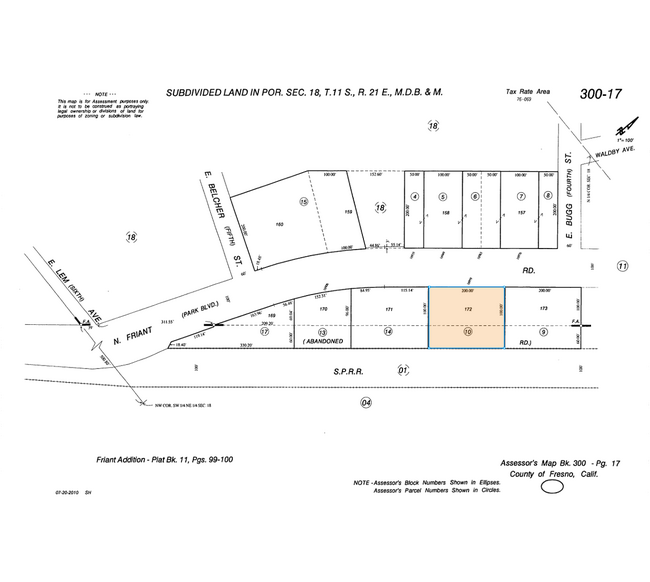
Friant Add
300-170-10
LOT 171 FRIANT ADD & ABANDONED RD
Commercialacreage
Fresno
X
California
06019C1030H
171
2025
0.73 AC
2025
E Outlying Fresno County
005515
Fresno
DEMOGRAPHICS near 16959 N Friant Rd
1 Mile
3 Mile
5 Mile
2024 Total Population
314
913
4,780
2029 Population
309
933
5,161
Pop Growth 2024-2029
(1.59%)
+ 2.19%
+ 7.97%
Average Age
45
43
43
2024 Total Households
114
324
1,781
HH Growth 2024-2029
(1.75%)
+ 2.16%
+ 8.31%
Median Household Inc
$128,571
$133,593
$99,588
Avg Household Size
2.60
2.80
2.60
2024 Avg HH Vehicles
3.00
3.00
3.00
Median Home Value
$759,259
$653,726
$662,618
Median Year Built
1992
1992
1999
Nearby Places
Map Layers
Map Styles
 Street
 Aerial
- Restaurants
- Banks
- Shops
- Fitness
- Groceries
PUBLIC TRANSPORTATION
AIRPORT
Fresno Yosemite International
DRIVE
WALK
Distance
Fresno Yosemite International
28 min
16.2 mi
Nearby Properties
Address
Land Use
TOTAL SIZE
Lot Size
Zoning
Address
Land Use
TOTAL SIZE
Lot Size
Zoning
1,403 SF
234.59 AC
ARF
Address
Land Use
TOTAL SIZE
Lot Size
Zoning
76.20 AC
Address
Land Use
TOTAL SIZE
Lot Size
Zoning
9,900 SF
8.97 AC
RA
Address
Land Use
TOTAL SIZE
Lot Size
Zoning
11,376 SF
1.06 AC
C6
Address
Land Use
TOTAL SIZE
Lot Size
Zoning
4,120 SF
3.42 AC
RRS
Address
Land Use
TOTAL SIZE
Lot Size
Zoning
111.53 AC
AE20
Address
Land Use
TOTAL SIZE
Lot Size
Zoning
102.65 AC
AE40
Address
Land Use
TOTAL SIZE
Lot Size
Zoning
2,032 SF
0.23 AC
Address
Land Use
TOTAL SIZE
Lot Size
Zoning
3 AC
RRS
Address
Land Use
TOTAL SIZE
Lot Size
Zoning
3,484 SF
0.53 AC
R1B
Address
Land Use
TOTAL SIZE
Lot Size
Zoning
2,809 SF
18.15 AC
ARF
Address
Land Use
TOTAL SIZE
Lot Size
Zoning
3,537 SF
0.28 AC
R1
Address
Land Use
TOTAL SIZE
Lot Size
Zoning
2,971 SF
0.31 AC
R1
Address
Land Use
TOTAL SIZE
Lot Size
Zoning
2,688 SF
0.80 AC
C6
Address
Land Use
TOTAL SIZE
Lot Size
Zoning
1.64 AC
RRS
Address
Land Use
TOTAL SIZE
Lot Size
Zoning
3,956 SF
0.88 AC
C6
Address
Land Use
TOTAL SIZE
Lot Size
Zoning
40.04 AC
ARF
Address
Land Use
TOTAL SIZE
Lot Size
Zoning
2,303 SF
0.27 AC
R1
Address
Land Use
TOTAL SIZE
Lot Size
Zoning
2.46 AC
RRS
Address
Land Use
TOTAL SIZE
Lot Size
Zoning
222.29 AC
AE40
Address
Land Use
TOTAL SIZE
Lot Size
Zoning
2.88 AC
AE20
Address
Land Use
TOTAL SIZE
Lot Size
Zoning
0.52 AC
C6
Address
Land Use
TOTAL SIZE
Lot Size
Zoning
677 SF
1.80 AC
CRG
The World's #1 Commercial Real Estate Marketplace
Connect with us
© 2026 CoStar Group
The information above has been obtained from sources believed reliable. While we do not doubt its accuracy we have not verified it and make no guarantee, warranty or representation about it. It is your responsibility to independently confirm its accuracy and completeness. Any projections, opinions, assumptions, or estimates used are for example only and do not represent the current or future performance of the property. The value of this transaction to you depends on tax and other factors which should be evaluated by your tax, financial, and legal advisors. You and your advisors should conduct a careful, independent investigation of the property to determine to your satisfaction the suitability of the property for your needs.