Property Record
16980 W Il Route 173, Wadsworth, IL 60083

Property Detail
16980 W Il Route 173
Chicago-Naperville-Elgin, IL-IN
PT E1/2 NE1/4;PT LYG ELY OF TOLL ROAD(EX VEG X ELY LN TOLL R OAD & NLN PT CONDEMED,NLY 50.5,E 374.2,SE 111.77,E 175,S E 21.46,W 267.51,NW 100.12,W 291.33 TO POB SECTION 17 TO
03-17-200-025
Lake
Farms
Illinois
B and X Area of moderate flood hazard, usually the area between the limits of the 100-year and 500-year floods.
6,1
2024
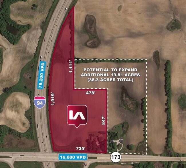
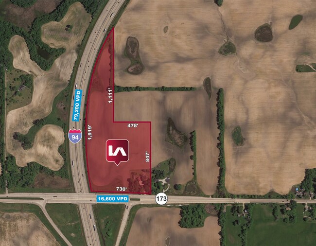
18.47 AC
2025
Far North
866000
Chicago
2,230 SF
NEARBY LISTINGS FOR SALE OR LEASE
DEMOGRAPHICS near 16980 W Il Route 173
1 mile
3 mile
5 mile
2025 Total Population
219
1,736
34,195
2030 Population
218
1,739
34,543
Pop Growth 2025-2030
(0.46%)
+ 0.17%
+ 1.02%
Average Age
45
45
40
2025 Total Households
77
627
11,881
HH Growth 2025-2030
0.00%
0.00%
+ 0.97%
Median Household Inc
$96,153
$98,129
$121,643
Avg Household Size
2.70
2.70
2.80
2025 Avg HH Vehicles
2.00
2.00
2.00
Median Home Value
$493,749
$441,954
$300,974
Median Year Built
1974
1984
1994
Nearby Places
Map Layers
Map Styles
 Street
 Aerial
Layers
 Traffic
 Biking
Places
Listings with unknown addresses are not visible on the map
- Restaurants
- Banks
- Shops
- Fitness
- Groceries
PUBLIC TRANSPORTATION
COMMUTER RAIL
Antioch Station (North Central Service - Northeast Illinois Regional Commuter Railroad (Metra))
Drive
Walk
Distance
Antioch Station (North Central Service - Northeast Illinois Regional Commuter Railroad (Metra))
12 min
7.7 mi
Freight Ports
Port Milwaukee
Drive
Walk
Distance
Port Milwaukee
47 min
40.2 mi
Nearby Properties
Address
Land Use
TOTAL SIZE
Lot Size
Zoning
Address
Land Use
TOTAL SIZE
Lot Size
Zoning
590,185 SF
46.90 AC
Address
Land Use
TOTAL SIZE
Lot Size
Zoning
558,250 SF
25.28 AC
Address
Land Use
TOTAL SIZE
Lot Size
Zoning
454,000 SF
23.60 AC
Address
Land Use
TOTAL SIZE
Lot Size
Zoning
161,950 SF
16.83 AC
Address
Land Use
TOTAL SIZE
Lot Size
Zoning
2,016 SF
80 AC
Address
Land Use
TOTAL SIZE
Lot Size
Zoning
70,214 SF
61.30 AC
Address
Land Use
TOTAL SIZE
Lot Size
Zoning
3,572 SF
77.40 AC
Address
Land Use
TOTAL SIZE
Lot Size
Zoning
6,400 SF
6 AC
Address
Land Use
TOTAL SIZE
Lot Size
Zoning
55,868 SF
3.48 AC
Address
Land Use
TOTAL SIZE
Lot Size
Zoning
13,494 SF
7.21 AC
Address
Land Use
TOTAL SIZE
Lot Size
Zoning
2,746 SF
29.16 AC
Address
Land Use
TOTAL SIZE
Lot Size
Zoning
41,161 SF
608.77 AC
Address
Land Use
TOTAL SIZE
Lot Size
Zoning
9,558 SF
9.36 AC
Address
Land Use
TOTAL SIZE
Lot Size
Zoning
34,106 SF
0.88 AC
Address
Land Use
TOTAL SIZE
Lot Size
Zoning
27,707 SF
5.28 AC
Address
Land Use
TOTAL SIZE
Lot Size
Zoning
22,280 SF
10.30 AC
Address
Land Use
TOTAL SIZE
Lot Size
Zoning
34,018 SF
4.32 AC
Address
Land Use
TOTAL SIZE
Lot Size
Zoning
7,940 SF
10 AC
Address
Land Use
TOTAL SIZE
Lot Size
Zoning
18,908 SF
5.01 AC
Address
Land Use
TOTAL SIZE
Lot Size
Zoning
41,078 SF
12.08 AC
Address
Land Use
TOTAL SIZE
Lot Size
Zoning
21,165 SF
26.46 AC
Address
Land Use
TOTAL SIZE
Lot Size
Zoning
10,080 SF
3.80 AC
Address
Land Use
TOTAL SIZE
Lot Size
Zoning
5,400 SF
6.88 AC
Address
Land Use
TOTAL SIZE
Lot Size
Zoning
7,039 SF
2.13 AC
Address
Land Use
TOTAL SIZE
Lot Size
Zoning
1,062 SF
5.82 AC
Address
Land Use
TOTAL SIZE
Lot Size
Zoning
17,600 SF
10.26 AC
Address
Land Use
TOTAL SIZE
Lot Size
Zoning
19,733 SF
7.55 AC
Address
Land Use
TOTAL SIZE
Lot Size
Zoning
7,906 SF
0.65 AC
Address
Land Use
TOTAL SIZE
Lot Size
Zoning
23,995 SF
9.80 AC
Address
Land Use
TOTAL SIZE
Lot Size
Zoning
2,038 SF
11.58 AC
The World's #1 Commercial Real Estate Marketplace
Connect with us
© 2026 CoStar Group
The information above has been obtained from sources believed reliable. While we do not doubt its accuracy we have not verified it and make no guarantee, warranty or representation about it. It is your responsibility to independently confirm its accuracy and completeness. Any projections, opinions, assumptions, or estimates used are for example only and do not represent the current or future performance of the property. The value of this transaction to you depends on tax and other factors which should be evaluated by your tax, financial, and legal advisors. You and your advisors should conduct a careful, independent investigation of the property to determine to your satisfaction the suitability of the property for your needs.