Property Record
17 Bridge St, Springvale, ME 04083
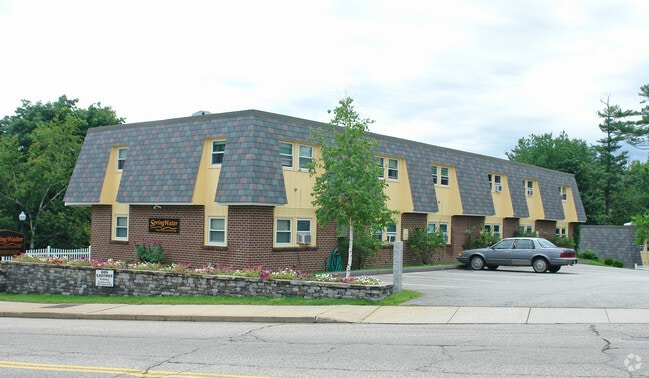

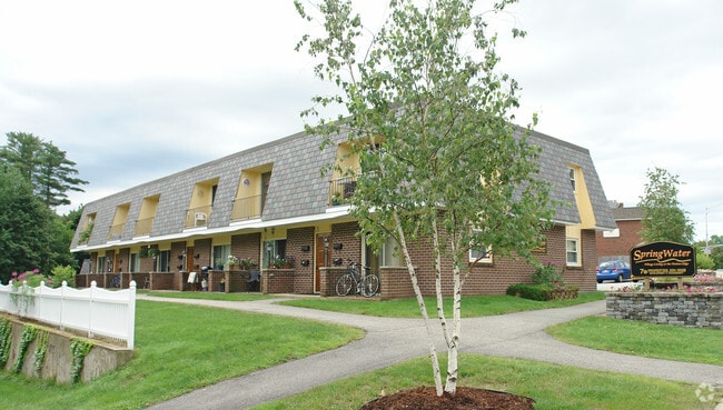
Property Detail
17 Bridge St
SANF-000049-K000015
York
Apartment
Maine
DB
0.91 AC
AE The base floodplain where base flood elevations are provided. AE Zones are now used on new format FIRMs instead of A1-A30 Zones.
York County
2025
Portland/South Portland
2025
Portland-South Portland, ME
030102
NEARBY LISTINGS FOR SALE OR LEASE
DEMOGRAPHICS near 17 Bridge St
1 mile
3 mile
5 mile
2025 Total Population
3,809
15,139
24,181
2030 Population
3,881
15,456
24,661
Pop Growth 2025-2030
+ 1.89%
+ 2.09%
+ 1.99%
Average Age
43
41
42
2025 Total Households
1,638
6,242
9,919
HH Growth 2025-2030
+ 1.83%
+ 2.02%
+ 1.93%
Median Household Inc
$73,724
$69,208
$77,619
Avg Household Size
2.30
2.30
2.30
2025 Avg HH Vehicles
2.00
2.00
2.00
Median Home Value
$279,253
$274,887
$298,981
Median Year Built
1968
1966
1974
Nearby Places
Map Layers
Map Styles
 Street
 Aerial
Transit
 Traffic
 Biking
Places
Listings with unknown addresses are not visible on the map
- Restaurants
- Banks
- Shops
- Fitness
- Groceries
PUBLIC TRANSPORTATION
AIRPORT
Portland International Jetport
Drive
Walk
Distance
Portland International Jetport
43 min
31.9 mi
Portsmouth International at Pease
Drive
Walk
Distance
Portsmouth International at Pease
56 min
34.9 mi
Freight Ports
Portland, ME
Drive
Walk
Distance
Portland, ME
44 min
34.5 mi
Nearby Properties
Address
Land Use
TOTAL SIZE
Lot Size
Zoning
Address
Land Use
TOTAL SIZE
Lot Size
Zoning
61,542 SF
11.50 AC
Address
Land Use
TOTAL SIZE
Lot Size
Zoning
94,234 SF
17.65 AC
OR
Address
Land Use
TOTAL SIZE
Lot Size
Zoning
Address
Land Use
TOTAL SIZE
Lot Size
Zoning
18.86 AC
SFR
Address
Land Use
TOTAL SIZE
Lot Size
Zoning
55,418 SF
1.54 AC
DB
Address
Land Use
TOTAL SIZE
Lot Size
Zoning
81.92 AC
SFR
Address
Land Use
TOTAL SIZE
Lot Size
Zoning
61,457 SF
0.87 AC
IR
Address
Land Use
TOTAL SIZE
Lot Size
Zoning
Address
Land Use
TOTAL SIZE
Lot Size
Zoning
16,708 SF
3 AC
DB
Address
Land Use
TOTAL SIZE
Lot Size
Zoning
8.60 AC
ORBP
Address
Land Use
TOTAL SIZE
Lot Size
Zoning
19,019 SF
19.41 AC
SFR
Address
Land Use
TOTAL SIZE
Lot Size
Zoning
71,566 SF
12 AC
UB
Address
Land Use
TOTAL SIZE
Lot Size
Zoning
1,080 SF
3.50 AC
GR
Address
Land Use
TOTAL SIZE
Lot Size
Zoning
78,259 SF
8.29 AC
SFR
Address
Land Use
TOTAL SIZE
Lot Size
Zoning
2.25 AC
GR
Address
Land Use
TOTAL SIZE
Lot Size
Zoning
17,176 SF
2.84 AC
IB
Address
Land Use
TOTAL SIZE
Lot Size
Zoning
4.40 AC
GR
Address
Land Use
TOTAL SIZE
Lot Size
Zoning
43,747 SF
1.12 AC
DB
Address
Land Use
TOTAL SIZE
Lot Size
Zoning
24,060 SF
0.92 AC
DB
Address
Land Use
TOTAL SIZE
Lot Size
Zoning
278,108 SF
2.78 AC
IR
Address
Land Use
TOTAL SIZE
Lot Size
Zoning
17,090 SF
0.63 AC
DB
Address
Land Use
TOTAL SIZE
Lot Size
Zoning
1.30 AC
DB
Address
Land Use
TOTAL SIZE
Lot Size
Zoning
44,460 SF
4.13 AC
UB
Address
Land Use
TOTAL SIZE
Lot Size
Zoning
1,080 SF
1.21 AC
GR
Address
Land Use
TOTAL SIZE
Lot Size
Zoning
55,040 SF
0.91 AC
DB
Address
Land Use
TOTAL SIZE
Lot Size
Zoning
50,437 SF
12.20 AC
SFR
Address
Land Use
TOTAL SIZE
Lot Size
Zoning
1,122 SF
2.43 AC
GR
Address
Land Use
TOTAL SIZE
Lot Size
Zoning
20,505 SF
0.89 AC
ORBP
Address
Land Use
TOTAL SIZE
Lot Size
Zoning
50,904 SF
1.17 AC
DB
Address
Land Use
TOTAL SIZE
Lot Size
Zoning
15,504 SF
0.84 AC
DB
The World's #1 Commercial Real Estate Marketplace
Connect with us
© 2026 CoStar Group
The information above has been obtained from sources believed reliable. While we do not doubt its accuracy we have not verified it and make no guarantee, warranty or representation about it. It is your responsibility to independently confirm its accuracy and completeness. Any projections, opinions, assumptions, or estimates used are for example only and do not represent the current or future performance of the property. The value of this transaction to you depends on tax and other factors which should be evaluated by your tax, financial, and legal advisors. You and your advisors should conduct a careful, independent investigation of the property to determine to your satisfaction the suitability of the property for your needs.