Property Record
17 Britton Dr, Bloomfield, CT 06002
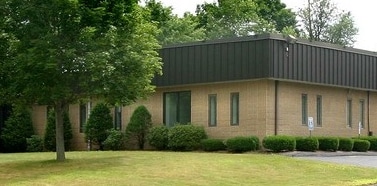

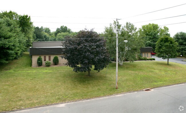
Property Detail
17 Britton Dr
BLOO-000893-000000-001042
Capitol
Industrialgeneral
Connecticut
I-2
11
B and X Area of moderate flood hazard, usually the area between the limits of the 100-year and 500-year floods.
2.09 AC
2024
Bloomfield
2025
Hartford
471200
Hartford-West Hartford-East Hartford, CT
18,458 SF
NEARBY LISTINGS FOR SALE OR LEASE
-
-
View all Bloomfield listings for sale on LoopNet.com
DEMOGRAPHICS near 17 Britton Dr
1 mile
3 mile
5 mile
2024 Total Population
9,669
88,407
212,535
2029 Population
9,802
90,157
216,269
Pop Growth 2024-2029
+ 1.38%
+ 1.98%
+ 1.76%
Average Age
40
40
39
2024 Total Households
3,170
34,139
85,292
HH Growth 2024-2029
+ 1.39%
+ 2.09%
+ 1.90%
Median Household Inc
$65,818
$62,646
$65,905
Avg Household Size
2.60
2.40
2.30
2024 Avg HH Vehicles
2.00
1.00
1.00
Median Home Value
$203,020
$279,756
$308,707
Median Year Built
1953
1958
1956
Nearby Places
Map Layers
Map Styles
 Street
 Aerial
Transit
 Traffic
 Biking
Places
Listings with unknown addresses are not visible on the map
- Restaurants
- Banks
- Shops
- Fitness
- Groceries
PUBLIC TRANSPORTATION
COMMUTER RAIL
Drive
Walk
Distance
11 min
4.7 mi
Drive
Walk
Distance
11 min
5.0 mi
AIRPORT
Bradley International
Drive
Walk
Distance
Bradley International
32 min
15.4 mi
Freight Ports
Port of New Haven
Drive
Walk
Distance
Port of New Haven
61 min
44.1 mi
Nearby Properties
Address
Land Use
TOTAL SIZE
Lot Size
Zoning
Address
Land Use
TOTAL SIZE
Lot Size
Zoning
88.48 AC
R-10
Address
Land Use
TOTAL SIZE
Lot Size
Zoning
1.45 AC
CAMP
Address
Land Use
TOTAL SIZE
Lot Size
Zoning
213,017 SF
6.21 AC
DT-3
Address
Land Use
TOTAL SIZE
Lot Size
Zoning
15,871 SF
42.80 AC
PO
Address
Land Use
TOTAL SIZE
Lot Size
Zoning
29.35 AC
CAMP
Address
Land Use
TOTAL SIZE
Lot Size
Zoning
584 AC
OS
Address
Land Use
TOTAL SIZE
Lot Size
Zoning
5.56 AC
CAMP
Address
Land Use
TOTAL SIZE
Lot Size
Zoning
28.02 AC
CAMP
Address
Land Use
TOTAL SIZE
Lot Size
Zoning
68.36 AC
Address
Land Use
TOTAL SIZE
Lot Size
Zoning
7.45 AC
CAMP
Address
Land Use
TOTAL SIZE
Lot Size
Zoning
227,898 SF
5.33 AC
BCD
Address
Land Use
TOTAL SIZE
Lot Size
Zoning
310,901 SF
28.75 AC
MX-2
Address
Land Use
TOTAL SIZE
Lot Size
Zoning
15.31 AC
DDZ
Address
Land Use
TOTAL SIZE
Lot Size
Zoning
197,704 SF
1.82 AC
CAMP
Address
Land Use
TOTAL SIZE
Lot Size
Zoning
211,308 SF
55.90 AC
R-13
Address
Land Use
TOTAL SIZE
Lot Size
Zoning
40,632 SF
1.10 AC
NX-1
Address
Land Use
TOTAL SIZE
Lot Size
Zoning
772,060 SF
17.90 AC
DDZ
Address
Land Use
TOTAL SIZE
Lot Size
Zoning
23.10 AC
R-20
Address
Land Use
TOTAL SIZE
Lot Size
Zoning
11.85 AC
MX-2
Address
Land Use
TOTAL SIZE
Lot Size
Zoning
172,026 SF
11.64 AC
MX-2
Address
Land Use
TOTAL SIZE
Lot Size
Zoning
10.74 AC
ID-1
Address
Land Use
TOTAL SIZE
Lot Size
Zoning
23.07 AC
CAMP
Address
Land Use
TOTAL SIZE
Lot Size
Zoning
15.39 AC
SDD/RM
Address
Land Use
TOTAL SIZE
Lot Size
Zoning
161,576 SF
4 AC
BCD
Address
Land Use
TOTAL SIZE
Lot Size
Zoning
39,281 SF
678.81 AC
R-80
Address
Land Use
TOTAL SIZE
Lot Size
Zoning
19.66 AC
CAMP
Address
Land Use
TOTAL SIZE
Lot Size
Zoning
82,938 SF
62.53 AC
I-1
Address
Land Use
TOTAL SIZE
Lot Size
Zoning
23.99 AC
ID-1
Address
Land Use
TOTAL SIZE
Lot Size
Zoning
77,497 SF
14.17 AC
R-20
Address
Land Use
TOTAL SIZE
Lot Size
Zoning
135,344 SF
17.85 AC
PO
The World's #1 Commercial Real Estate Marketplace
Connect with us
© 2026 CoStar Group
The information above has been obtained from sources believed reliable. While we do not doubt its accuracy we have not verified it and make no guarantee, warranty or representation about it. It is your responsibility to independently confirm its accuracy and completeness. Any projections, opinions, assumptions, or estimates used are for example only and do not represent the current or future performance of the property. The value of this transaction to you depends on tax and other factors which should be evaluated by your tax, financial, and legal advisors. You and your advisors should conduct a careful, independent investigation of the property to determine to your satisfaction the suitability of the property for your needs.