Property Record
17 Cape Dr, Mashpee, MA 02649
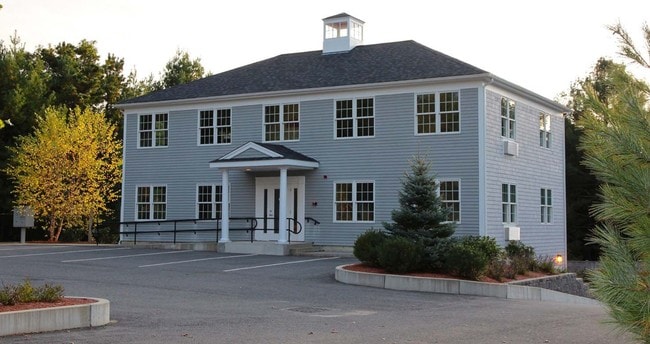

Property Detail
17 Cape Dr
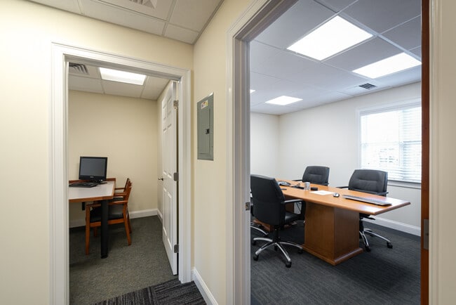
Officebuilding
Barnstable
C2
Massachusetts
B and X Area of moderate flood hazard, usually the area between the limits of the 100-year and 500-year floods.
0.65 AC
2025
Cape Cod
2025
Other Market Areas
015100
Barnstable Town, MA
5,100 SF
MASH-000055-000020
NEARBY LISTINGS FOR SALE OR LEASE
DEMOGRAPHICS near 17 Cape Dr
1 mile
3 mile
5 mile
2025 Total Population
3,069
16,822
40,241
2030 Population
3,050
16,543
39,791
Pop Growth 2025-2030
(0.62%)
(1.66%)
(1.12%)
Average Age
48
49
49
2025 Total Households
1,260
7,250
17,205
HH Growth 2025-2030
(0.79%)
(1.86%)
(0.97%)
Median Household Inc
$93,004
$98,843
$106,348
Avg Household Size
2.30
2.30
2.30
2025 Avg HH Vehicles
2.00
2.00
2.00
Median Home Value
$558,317
$643,787
$675,321
Median Year Built
1986
1985
1984
Nearby Places
Map Layers
Map Styles
 Street
 Aerial
Transit
 Traffic
 Biking
Places
Listings with unknown addresses are not visible on the map
- Restaurants
- Banks
- Shops
- Fitness
- Groceries
PUBLIC TRANSPORTATION
AIRPORT
Martha's Vineyard
Drive
Walk
Distance
Martha's Vineyard
88 min
28.9 mi
Freight Ports
Port of New Bedford Harbor
Drive
Walk
Distance
Port of New Bedford Harbor
61 min
43.1 mi
SALE & LEASE HISTORY
LISTING DATE
SALE/LEASE

Oct 07, 2020
For Lease
Nearby Properties
Address
Land Use
TOTAL SIZE
Lot Size
Zoning
Address
Land Use
TOTAL SIZE
Lot Size
Zoning
12,713 SF
29.28 AC
C1
Address
Land Use
TOTAL SIZE
Lot Size
Zoning
10.94 AC
R3
Address
Land Use
TOTAL SIZE
Lot Size
Zoning
181,756 SF
135.43 AC
R5
Address
Land Use
TOTAL SIZE
Lot Size
Zoning
9 AC
C1
Address
Land Use
TOTAL SIZE
Lot Size
Zoning
15.10 AC
C1
Address
Land Use
TOTAL SIZE
Lot Size
Zoning
3.28 AC
RF
Address
Land Use
TOTAL SIZE
Lot Size
Zoning
24.40 AC
R3
Address
Land Use
TOTAL SIZE
Lot Size
Zoning
2,993 SF
67.60 AC
R3
Address
Land Use
TOTAL SIZE
Lot Size
Zoning
65,930 SF
3.97 AC
C1
Address
Land Use
TOTAL SIZE
Lot Size
Zoning
6.44 AC
RF
Address
Land Use
TOTAL SIZE
Lot Size
Zoning
8,472 SF
14.29 AC
R
Address
Land Use
TOTAL SIZE
Lot Size
Zoning
6,460 SF
9 AC
RF
Address
Land Use
TOTAL SIZE
Lot Size
Zoning
2,429 SF
67.57 AC
R
Address
Land Use
TOTAL SIZE
Lot Size
Zoning
4.66 AC
R
Address
Land Use
TOTAL SIZE
Lot Size
Zoning
24.50 AC
C2
Address
Land Use
TOTAL SIZE
Lot Size
Zoning
27.80 AC
R3
Address
Land Use
TOTAL SIZE
Lot Size
Zoning
13.30 AC
I1
Address
Land Use
TOTAL SIZE
Lot Size
Zoning
8,544 SF
20.31 AC
R3
Address
Land Use
TOTAL SIZE
Lot Size
Zoning
6.27 AC
R3
Address
Land Use
TOTAL SIZE
Lot Size
Zoning
Address
Land Use
TOTAL SIZE
Lot Size
Zoning
8,910 SF
31.84 AC
R5
Address
Land Use
TOTAL SIZE
Lot Size
Zoning
31,520 SF
3.89 AC
I1
Address
Land Use
TOTAL SIZE
Lot Size
Zoning
9,162 SF
3.11 AC
RF
Address
Land Use
TOTAL SIZE
Lot Size
Zoning
1.34 AC
RF
Address
Land Use
TOTAL SIZE
Lot Size
Zoning
3.92 AC
R
Address
Land Use
TOTAL SIZE
Lot Size
Zoning
7,528 SF
2.20 AC
RF
Address
Land Use
TOTAL SIZE
Lot Size
Zoning
Address
Land Use
TOTAL SIZE
Lot Size
Zoning
2.32 AC
RF
Address
Land Use
TOTAL SIZE
Lot Size
Zoning
1.52 AC
RF;RF-
Address
Land Use
TOTAL SIZE
Lot Size
Zoning
34.48 AC
R
The World's #1 Commercial Real Estate Marketplace
Connect with us
© 2026 CoStar Group
The information above has been obtained from sources believed reliable. While we do not doubt its accuracy we have not verified it and make no guarantee, warranty or representation about it. It is your responsibility to independently confirm its accuracy and completeness. Any projections, opinions, assumptions, or estimates used are for example only and do not represent the current or future performance of the property. The value of this transaction to you depends on tax and other factors which should be evaluated by your tax, financial, and legal advisors. You and your advisors should conduct a careful, independent investigation of the property to determine to your satisfaction the suitability of the property for your needs.