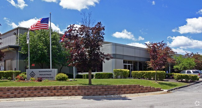
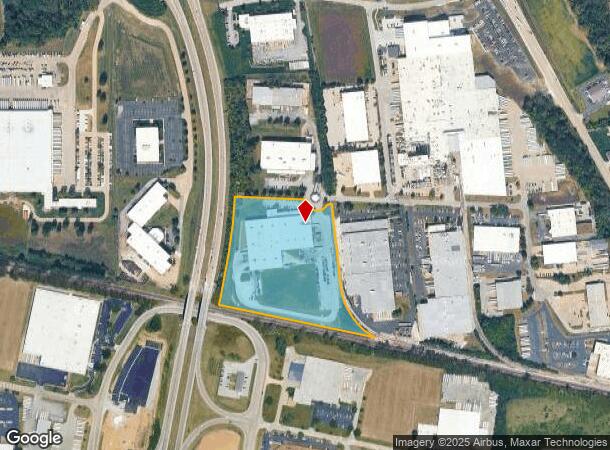
Property Record
17 Cermak Blvd, Saint Peters, MO 63376
NEARBY LISTINGS FOR SALE OR LEASE
Property Detail
17 Cermak Blvd
St. Louis
Arrowhead Ind Pk Sec E
St. Louis, MO-IL
ARROWHEAD IND PK SEC F
2-106A-5082-00-000F.0000000
St. Charles
Industrialgeneral
Missouri
2024
f
2025
11.14 AC
311500
St Charles County
109,484 SF
DEMOGRAPHICS near 17 Cermak Blvd
1 Mile
3 Mile
5 Mile
2024 Total Population
1,340
49,677
132,343
2029 Population
1,401
52,388
139,687
Pop Growth 2024-2029
+ 4.55%
+ 5.46%
+ 5.55%
Average Age
42
41
41
2024 Total Households
565
19,251
50,578
HH Growth 2024-2029
+ 4.60%
+ 5.54%
+ 5.65%
Median Household Inc
$64,886
$83,940
$91,379
Avg Household Size
2.30
2.50
2.60
2024 Avg HH Vehicles
2.00
2.00
2.00
Median Home Value
$185,439
$239,648
$256,589
Median Year Built
1978
1990
1991
Nearby Places
Map Layers
Map Styles
 Street
 Aerial
- Restaurants
- Banks
- Shops
- Fitness
- Groceries
PUBLIC TRANSPORTATION
AIRPORT
St Louis Lambert International
DRIVE
WALK
Distance
St Louis Lambert International
30 min
19.4 mi
Freight Ports
Port Milwaukee
DRIVE
WALK
Distance
Port Milwaukee
449 min
392.5 mi
Nearby Properties
Address
Land Use
TOTAL SIZE
Lot Size
Zoning
Address
Land Use
TOTAL SIZE
Lot Size
Zoning
500,420 SF
99.80 AC
Address
Land Use
TOTAL SIZE
Lot Size
Zoning
136,142 SF
31.16 AC
Address
Land Use
TOTAL SIZE
Lot Size
Zoning
189,054 SF
24.92 AC
AA1
Address
Land Use
TOTAL SIZE
Lot Size
Zoning
71,908 SF
8.72 AC
Address
Land Use
TOTAL SIZE
Lot Size
Zoning
279,526 SF
7.73 AC
Address
Land Use
TOTAL SIZE
Lot Size
Zoning
143,897 SF
7.17 AC
Address
Land Use
TOTAL SIZE
Lot Size
Zoning
182,783 SF
19.83 AC
Address
Land Use
TOTAL SIZE
Lot Size
Zoning
449,111 SF
16.30 AC
AE2
Address
Land Use
TOTAL SIZE
Lot Size
Zoning
56,430 SF
14.72 AC
AE8
Address
Land Use
TOTAL SIZE
Lot Size
Zoning
28,215 SF
8.58 AC
AB6
Address
Land Use
TOTAL SIZE
Lot Size
Zoning
246,351 SF
9.69 AC
Address
Land Use
TOTAL SIZE
Lot Size
Zoning
342,840 SF
58.93 AC
AB6
Address
Land Use
TOTAL SIZE
Lot Size
Zoning
235,876 SF
11.35 AC
Address
Land Use
TOTAL SIZE
Lot Size
Zoning
46,388 SF
10.76 AC
Address
Land Use
TOTAL SIZE
Lot Size
Zoning
75.10 AC
AC7
Address
Land Use
TOTAL SIZE
Lot Size
Zoning
46,980 SF
4.15 AC
AF0
Address
Land Use
TOTAL SIZE
Lot Size
Zoning
160,312 SF
6.82 AC
Address
Land Use
TOTAL SIZE
Lot Size
Zoning
513,174 SF
19.75 AC
AB6
Address
Land Use
TOTAL SIZE
Lot Size
Zoning
399,520 SF
16.98 AC
AB3
Address
Land Use
TOTAL SIZE
Lot Size
Zoning
93.68 AC
AF0
Address
Land Use
TOTAL SIZE
Lot Size
Zoning
591,516 SF
28.79 AC
AB2
Address
Land Use
TOTAL SIZE
Lot Size
Zoning
32.19 AC
AA1
Address
Land Use
TOTAL SIZE
Lot Size
Zoning
104,807 SF
9.34 AC
AB6
Address
Land Use
TOTAL SIZE
Lot Size
Zoning
203,833 SF
13.92 AC
AE8
Address
Land Use
TOTAL SIZE
Lot Size
Zoning
36,438 SF
2.08 AC
AC4
Address
Land Use
TOTAL SIZE
Lot Size
Zoning
429,473 SF
82.18 AC
Address
Land Use
TOTAL SIZE
Lot Size
Zoning
562,434 SF
40.73 AC
AB3
Address
Land Use
TOTAL SIZE
Lot Size
Zoning
53,636 SF
Address
Land Use
TOTAL SIZE
Lot Size
Zoning
201,531 SF
22.28 AC
Address
Land Use
TOTAL SIZE
Lot Size
Zoning
249,889 SF
26.95 AC
The World's #1 Commercial Real Estate Marketplace
Connect with us
© 2026 CoStar Group
The information above has been obtained from sources believed reliable. While we do not doubt its accuracy we have not verified it and make no guarantee, warranty or representation about it. It is your responsibility to independently confirm its accuracy and completeness. Any projections, opinions, assumptions, or estimates used are for example only and do not represent the current or future performance of the property. The value of this transaction to you depends on tax and other factors which should be evaluated by your tax, financial, and legal advisors. You and your advisors should conduct a careful, independent investigation of the property to determine to your satisfaction the suitability of the property for your needs.