Property Record
17 Clinton Dr, Hollis, NH 03049


NEARBY LISTINGS FOR SALE OR LEASE
-
-
View all Hollis listings for lease on LoopNet.com
Property Detail
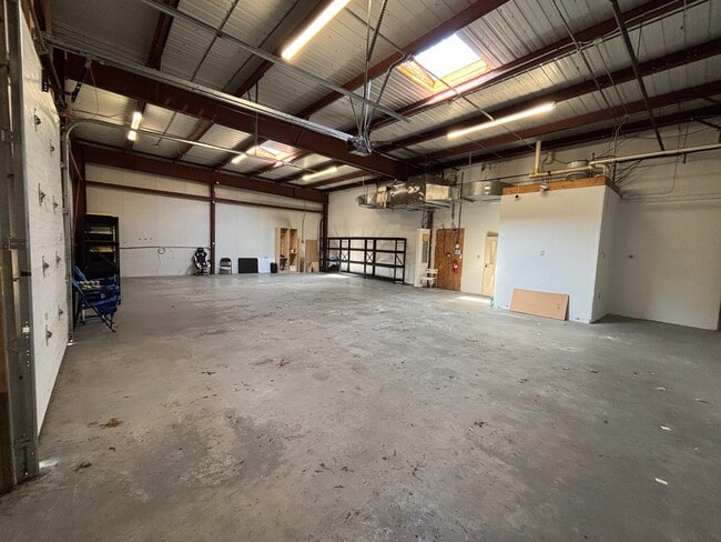
17 Clinton Dr
Industrialgeneral
Hillsborough
X
New Hampshire
25017C0083F
6.02 AC
2024
Hillsborough
2024
Boston
017101
Manchester-Nashua, NH
34,620 SF
HOLS-000004-000000-000074
DEMOGRAPHICS near 17 Clinton Dr
1 Mile
3 Mile
5 Mile
2024 Total Population
1,825
16,112
63,274
2029 Population
1,835
16,294
63,986
Pop Growth 2024-2029
+ 0.55%
+ 1.13%
+ 1.13%
Average Age
46
44
43
2024 Total Households
712
6,283
24,752
HH Growth 2024-2029
+ 0.56%
+ 1.18%
+ 1.14%
Median Household Inc
$133,285
$118,122
$112,609
Avg Household Size
2.60
2.50
2.50
2024 Avg HH Vehicles
2.00
2.00
2.00
Median Home Value
$488,888
$422,743
$401,080
Median Year Built
1987
1983
1979
Nearby Places
Map Layers
Map Styles
 Street
 Aerial
- Restaurants
- Banks
- Shops
- Fitness
- Groceries
PUBLIC TRANSPORTATION
AIRPORT
Manchester Boston Regional
DRIVE
WALK
Distance
Manchester Boston Regional
34 min
20.0 mi
Worcester Regional
DRIVE
WALK
Distance
Worcester Regional
76 min
49.5 mi
Freight Ports
Port of Boston
DRIVE
WALK
Distance
Port of Boston
76 min
52.7 mi
SALE & LEASE HISTORY
LISTING DATE
SALE/LEASE

Sep 25, 2016
For Lease
Jun 25, 2020
For Lease
Feb 05, 2020
For Lease
Dec 13, 2022
For Lease
Nearby Properties
Address
Land Use
TOTAL SIZE
Lot Size
Zoning
Address
Land Use
TOTAL SIZE
Lot Size
Zoning
42.06 AC
IND
Address
Land Use
TOTAL SIZE
Lot Size
Zoning
153,429 SF
76 AC
TC
Address
Land Use
TOTAL SIZE
Lot Size
Zoning
Address
Land Use
TOTAL SIZE
Lot Size
Zoning
1,440 SF
111.23 AC
R9
Address
Land Use
TOTAL SIZE
Lot Size
Zoning
3.75 AC
R9
Address
Land Use
TOTAL SIZE
Lot Size
Zoning
297.34 AC
R30
Address
Land Use
TOTAL SIZE
Lot Size
Zoning
64,987 SF
58 AC
R30
Address
Land Use
TOTAL SIZE
Lot Size
Zoning
96,025 SF
8.63 AC
TC
Address
Land Use
TOTAL SIZE
Lot Size
Zoning
12.43 AC
R40
Address
Land Use
TOTAL SIZE
Lot Size
Zoning
9.16 AC
IND
Address
Land Use
TOTAL SIZE
Lot Size
Zoning
28,720 SF
11.58 AC
R9
Address
Land Use
TOTAL SIZE
Lot Size
Zoning
51.83 AC
R9
Address
Land Use
TOTAL SIZE
Lot Size
Zoning
2,380 SF
44.26 AC
MH1
Address
Land Use
TOTAL SIZE
Lot Size
Zoning
12.63 AC
R9
Address
Land Use
TOTAL SIZE
Lot Size
Zoning
13.19 AC
SUR
Address
Land Use
TOTAL SIZE
Lot Size
Zoning
1,288 SF
31.64 AC
R9
Address
Land Use
TOTAL SIZE
Lot Size
Zoning
36,856 SF
5.66 AC
R9
Address
Land Use
TOTAL SIZE
Lot Size
Zoning
12.07 AC
R40
Address
Land Use
TOTAL SIZE
Lot Size
Zoning
6.69 AC
R30
Address
Land Use
TOTAL SIZE
Lot Size
Zoning
927 SF
0.63 AC
TC
Address
Land Use
TOTAL SIZE
Lot Size
Zoning
3,023 SF
16 AC
RA
Address
Land Use
TOTAL SIZE
Lot Size
Zoning
9 AC
R9
Address
Land Use
TOTAL SIZE
Lot Size
Zoning
175.67 AC
RUR
Address
Land Use
TOTAL SIZE
Lot Size
Zoning
80.04 AC
R40
Address
Land Use
TOTAL SIZE
Lot Size
Zoning
9,634 SF
R30
Address
Land Use
TOTAL SIZE
Lot Size
Zoning
47,310 SF
128.83 AC
AB
Address
Land Use
TOTAL SIZE
Lot Size
Zoning
23,720 SF
4.19 AC
IN
Address
Land Use
TOTAL SIZE
Lot Size
Zoning
23,312 SF
7.38 AC
AB
Address
Land Use
TOTAL SIZE
Lot Size
Zoning
25,400 SF
9.30 AC
IND
The World's #1 Commercial Real Estate Marketplace
Connect with us
© 2025 CoStar Group
The information above has been obtained from sources believed reliable. While we do not doubt its accuracy we have not verified it and make no guarantee, warranty or representation about it. It is your responsibility to independently confirm its accuracy and completeness. Any projections, opinions, assumptions, or estimates used are for example only and do not represent the current or future performance of the property. The value of this transaction to you depends on tax and other factors which should be evaluated by your tax, financial, and legal advisors. You and your advisors should conduct a careful, independent investigation of the property to determine to your satisfaction the suitability of the property for your needs.