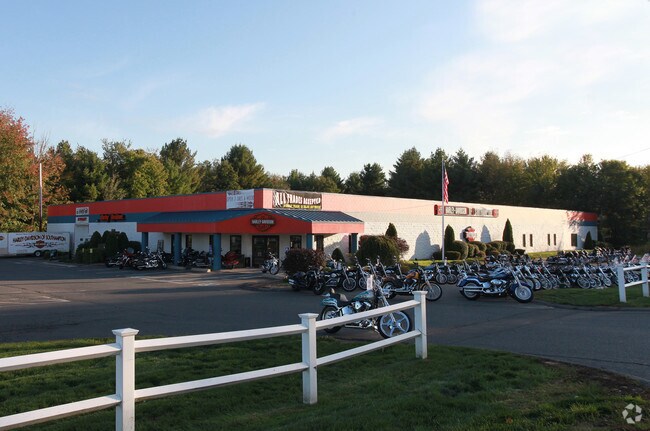
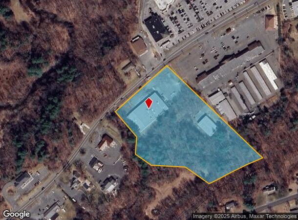
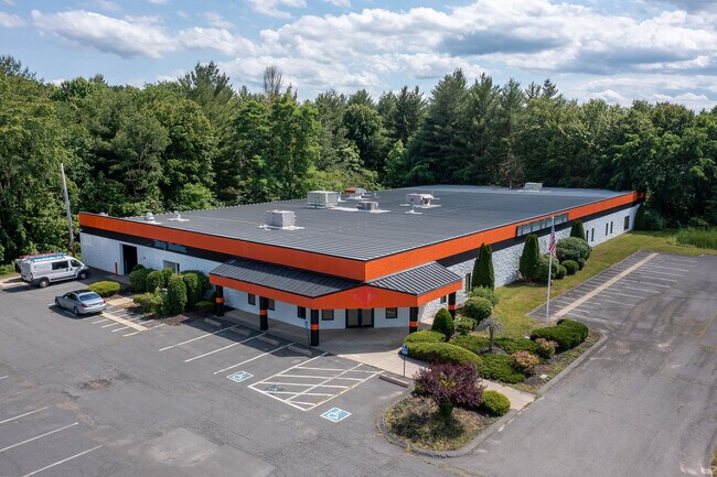
Property Record
17 College Hwy, Southampton, MA 01073
NEARBY LISTINGS FOR SALE OR LEASE
-
-
View all Southampton listings for lease on LoopNet.com
Property Detail
17 College Hwy
SHAM-000014-000042
Hampshire
Commercialnec
Massachusetts
2025
6.82 AC
2025
Hampshire County
822500
Hartford
1,104 SF
Springfield, MA
DEMOGRAPHICS near 17 College Hwy
1 Mile
3 Mile
5 Mile
2024 Total Population
1,874
18,270
42,286
2029 Population
1,468
14,454
36,244
Pop Growth 2024-2029
(21.66%)
(20.89%)
(14.29%)
Average Age
46
45
44
2024 Total Households
788
8,218
18,262
HH Growth 2024-2029
(22.21%)
(21.26%)
(14.96%)
Median Household Inc
$96,738
$72,299
$72,032
Avg Household Size
2.30
2.20
2.30
2024 Avg HH Vehicles
2.00
2.00
2.00
Median Home Value
$385,713
$335,212
$326,759
Median Year Built
1983
1969
1963
Nearby Places
Map Layers
Map Styles
 Street
 Aerial
- Restaurants
- Banks
- Shops
- Fitness
- Groceries
PUBLIC TRANSPORTATION
COMMUTER RAIL
Northampton (Valley Flyer - Amtrak, Vermonter - Amtrak)
DRIVE
WALK
Distance
Northampton (Valley Flyer - Amtrak, Vermonter - Amtrak)
11 min
6.6 mi
Holyoke Amtrak (Valley Flyer - Amtrak, Vermonter - Amtrak)
DRIVE
WALK
Distance
Holyoke Amtrak (Valley Flyer - Amtrak, Vermonter - Amtrak)
16 min
8.6 mi
AIRPORT
Bradley International
DRIVE
WALK
Distance
Bradley International
53 min
28.0 mi
Freight Ports
Albany, NY Port
DRIVE
WALK
Distance
Albany, NY Port
103 min
82.5 mi
SALE & LEASE HISTORY
LISTING DATE
SALE/LEASE

Jun 19, 2022
For Lease
Jun 19, 2022
For Sale
Nearby Properties
Address
Land Use
TOTAL SIZE
Lot Size
Zoning
Address
Land Use
TOTAL SIZE
Lot Size
Zoning
42,416 SF
17.58 AC
R10
Address
Land Use
TOTAL SIZE
Lot Size
Zoning
126,515 SF
183.24 AC
R40
Address
Land Use
TOTAL SIZE
Lot Size
Zoning
5,272 SF
16.12 AC
R10
Address
Land Use
TOTAL SIZE
Lot Size
Zoning
4,114 SF
125.44 AC
R35
Address
Land Use
TOTAL SIZE
Lot Size
Zoning
115,407 SF
7.53 AC
R10
Address
Land Use
TOTAL SIZE
Lot Size
Zoning
48,626 SF
4.25 AC
DB
Address
Land Use
TOTAL SIZE
Lot Size
Zoning
16,720 SF
5.74 AC
HB
Address
Land Use
TOTAL SIZE
Lot Size
Zoning
67,783 SF
16.51 AC
Address
Land Use
TOTAL SIZE
Lot Size
Zoning
6.90 AC
Address
Land Use
TOTAL SIZE
Lot Size
Zoning
29,946 SF
6.36 AC
HB
Address
Land Use
TOTAL SIZE
Lot Size
Zoning
14.80 AC
Address
Land Use
TOTAL SIZE
Lot Size
Zoning
480,770 SF
6.98 AC
MI
Address
Land Use
TOTAL SIZE
Lot Size
Zoning
3,792 SF
7.27 AC
R15
Address
Land Use
TOTAL SIZE
Lot Size
Zoning
90,748 SF
MI
Address
Land Use
TOTAL SIZE
Lot Size
Zoning
43,286 SF
0.71 AC
R5
Address
Land Use
TOTAL SIZE
Lot Size
Zoning
106,823 SF
5.31 AC
MI
Address
Land Use
TOTAL SIZE
Lot Size
Zoning
15,674 SF
3.77 AC
R10
Address
Land Use
TOTAL SIZE
Lot Size
Zoning
33,275 SF
0.71 AC
DB
Address
Land Use
TOTAL SIZE
Lot Size
Zoning
29,142 SF
2.78 AC
R15
Address
Land Use
TOTAL SIZE
Lot Size
Zoning
98,189 SF
1.65 AC
MI
Address
Land Use
TOTAL SIZE
Lot Size
Zoning
30,517 SF
0.73 AC
DB
Address
Land Use
TOTAL SIZE
Lot Size
Zoning
4.06 AC
Address
Land Use
TOTAL SIZE
Lot Size
Zoning
11,400 SF
6.93 AC
R15
Address
Land Use
TOTAL SIZE
Lot Size
Zoning
27,096 SF
1.40 AC
R10
Address
Land Use
TOTAL SIZE
Lot Size
Zoning
101,406 SF
4.34 AC
MI
Address
Land Use
TOTAL SIZE
Lot Size
Zoning
25,840 SF
1.31 AC
DB
Address
Land Use
TOTAL SIZE
Lot Size
Zoning
3,504 SF
2.46 AC
R10
Address
Land Use
TOTAL SIZE
Lot Size
Zoning
8,700 SF
2.03 AC
R10
Address
Land Use
TOTAL SIZE
Lot Size
Zoning
23,070 SF
21.94 AC
R35
Address
Land Use
TOTAL SIZE
Lot Size
Zoning
49,944 SF
12.80 AC
I
The World's #1 Commercial Real Estate Marketplace
Connect with us
© 2026 CoStar Group
The information above has been obtained from sources believed reliable. While we do not doubt its accuracy we have not verified it and make no guarantee, warranty or representation about it. It is your responsibility to independently confirm its accuracy and completeness. Any projections, opinions, assumptions, or estimates used are for example only and do not represent the current or future performance of the property. The value of this transaction to you depends on tax and other factors which should be evaluated by your tax, financial, and legal advisors. You and your advisors should conduct a careful, independent investigation of the property to determine to your satisfaction the suitability of the property for your needs.