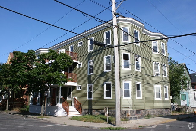
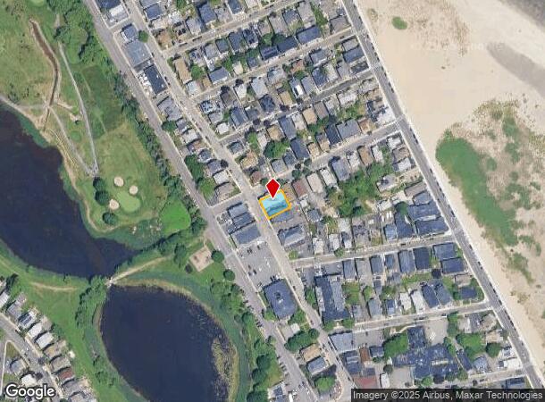
Property Record
17 Cutler St, Winthrop, MA 02152


NEARBY LISTINGS FOR SALE OR LEASE
-
-
-
No Photo
-
View all Winthrop listings for sale on LoopNet.com
Property Detail
17 Cutler St
WINT-000039-000000-000110
Winthrop
Apartment
Suffolk
AE
Massachusetts
25025C0101J
110
2025
0.11 AC
2025
Winthrop Beach
180500
Boston
7,092 SF
Boston-Cambridge-Newton, MA-NH
DEMOGRAPHICS near 17 Cutler St
1 Mile
3 Mile
5 Mile
2024 Total Population
13,571
50,015
276,517
2029 Population
12,509
46,792
262,882
Pop Growth 2024-2029
(7.83%)
(6.44%)
(4.93%)
Average Age
45
40
38
2024 Total Households
5,814
19,207
115,228
HH Growth 2024-2029
(8.43%)
(6.83%)
(5.04%)
Median Household Inc
$87,500
$74,186
$93,105
Avg Household Size
2.30
2.50
2.30
2024 Avg HH Vehicles
1.00
1.00
1.00
Median Home Value
$631,360
$606,226
$678,093
Median Year Built
1947
1948
1954
Nearby Places
Map Layers
Map Styles
 Street
 Aerial
- Restaurants
- Banks
- Shops
- Fitness
- Groceries
PUBLIC TRANSPORTATION
COMMUTER RAIL
DRIVE
WALK
Distance
11 min
6.0 mi
North Station (Fitchburg/South Acton Line - Massachusetts Bay Transportation Authority Commuter Rail (Purple Line), Haverhill Line - Massachusetts Bay Transportation Authority Commuter Rail (Purple Line), Lowell Line - Massachusetts Bay Transportation Authority Commuter Rail (Purple Line), Newburyport/Rockport Line - Massachusetts Bay Transportation Authority Commuter Rail (Purple Line))
DRIVE
WALK
Distance
North Station (Fitchburg/South Acton Line - Massachusetts Bay Transportation Authority Commuter Rail (Purple Line), Haverhill Line - Massachusetts Bay Transportation Authority Commuter Rail (Purple Line), Lowell Line - Massachusetts Bay Transportation Authority Commuter Rail (Purple Line), Newburyport/Rockport Line - Massachusetts Bay Transportation Authority Commuter Rail (Purple Line))
13 min
6.4 mi
AIRPORT
General Edward Lawrence Logan International
DRIVE
WALK
Distance
General Edward Lawrence Logan International
11 min
5.4 mi
Freight Ports
Port of Boston
DRIVE
WALK
Distance
Port of Boston
17 min
8.1 mi
SALE & LEASE HISTORY
LISTING DATE
SALE/LEASE

May 03, 2021
For Sale
Nearby Properties
Address
Land Use
TOTAL SIZE
Lot Size
Zoning
Address
Land Use
TOTAL SIZE
Lot Size
Zoning
171,791 SF
166.88 AC
E
Address
Land Use
TOTAL SIZE
Lot Size
Zoning
247,013 SF
1.13 AC
RC2
Address
Land Use
TOTAL SIZE
Lot Size
Zoning
164,959 SF
96.81 AC
E
Address
Land Use
TOTAL SIZE
Lot Size
Zoning
211,294 SF
1.66 AC
RC2
Address
Land Use
TOTAL SIZE
Lot Size
Zoning
226,431 SF
4.31 AC
HB
Address
Land Use
TOTAL SIZE
Lot Size
Zoning
154.16 AC
E
Address
Land Use
TOTAL SIZE
Lot Size
Zoning
5,668 SF
20.05 AC
A
Address
Land Use
TOTAL SIZE
Lot Size
Zoning
391,884 SF
108.79 AC
C
Address
Land Use
TOTAL SIZE
Lot Size
Zoning
738 SF
20.71 AC
PORT
Address
Land Use
TOTAL SIZE
Lot Size
Zoning
449,900 SF
3.38 AC
I
Address
Land Use
TOTAL SIZE
Lot Size
Zoning
214,895 SF
3.30 AC
A
Address
Land Use
TOTAL SIZE
Lot Size
Zoning
192,881 SF
6.08 AC
C
Address
Land Use
TOTAL SIZE
Lot Size
Zoning
224,868 SF
9.08 AC
I
Address
Land Use
TOTAL SIZE
Lot Size
Zoning
192,031 SF
8.34 AC
Address
Land Use
TOTAL SIZE
Lot Size
Zoning
130,120 SF
0.83 AC
RC2
Address
Land Use
TOTAL SIZE
Lot Size
Zoning
115,045 SF
6.90 AC
C
Address
Land Use
TOTAL SIZE
Lot Size
Zoning
181,959 SF
1.38 AC
RC2
Address
Land Use
TOTAL SIZE
Lot Size
Zoning
81.22 AC
E
Address
Land Use
TOTAL SIZE
Lot Size
Zoning
117,516 SF
1.68 AC
R2
Address
Land Use
TOTAL SIZE
Lot Size
Zoning
29.47 AC
HB
Address
Land Use
TOTAL SIZE
Lot Size
Zoning
333,370 SF
10.34 AC
C
Address
Land Use
TOTAL SIZE
Lot Size
Zoning
142,500 SF
27.98 AC
PDD2
Address
Land Use
TOTAL SIZE
Lot Size
Zoning
88,200 SF
17.33 AC
C
Address
Land Use
TOTAL SIZE
Lot Size
Zoning
92,853 SF
1.87 AC
E
Address
Land Use
TOTAL SIZE
Lot Size
Zoning
108,216 SF
4.71 AC
RB
Address
Land Use
TOTAL SIZE
Lot Size
Zoning
131,972 SF
5.34 AC
TED
Address
Land Use
TOTAL SIZE
Lot Size
Zoning
167,334 SF
1.80 AC
RC2
Address
Land Use
TOTAL SIZE
Lot Size
Zoning
84,855 SF
10.25 AC
Address
Land Use
TOTAL SIZE
Lot Size
Zoning
1,134 SF
21.01 AC
TED
Address
Land Use
TOTAL SIZE
Lot Size
Zoning
126,484 SF
1.31 AC
RC2
The World's #1 Commercial Real Estate Marketplace
Connect with us
© 2025 CoStar Group
The information above has been obtained from sources believed reliable. While we do not doubt its accuracy we have not verified it and make no guarantee, warranty or representation about it. It is your responsibility to independently confirm its accuracy and completeness. Any projections, opinions, assumptions, or estimates used are for example only and do not represent the current or future performance of the property. The value of this transaction to you depends on tax and other factors which should be evaluated by your tax, financial, and legal advisors. You and your advisors should conduct a careful, independent investigation of the property to determine to your satisfaction the suitability of the property for your needs.