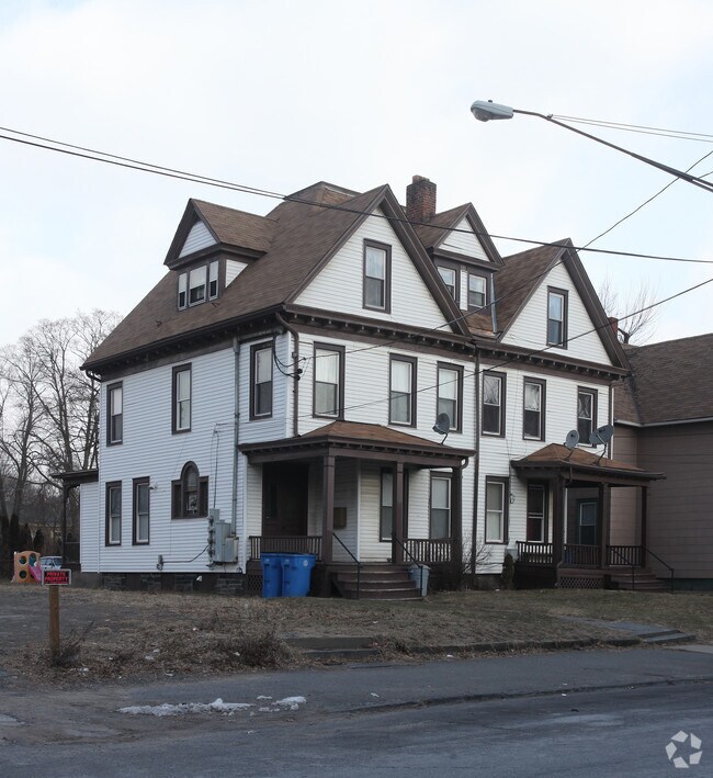
Property Record
17 Downs St, Kingston, NY 12401

Property Detail
17 Downs St
0800-056.025-0001-024.000-0000
Ulster
Apartment
New York
T5N
24.000
B and X Area of moderate flood hazard, usually the area between the limits of the 100-year and 500-year floods.
0.15 AC
2025
Downtown Kingston
2024
Other Market Areas
952000
Kingston, NY
4,074 SF
NEARBY LISTINGS FOR SALE OR LEASE
DEMOGRAPHICS near 17 Downs St
1 mile
3 mile
5 mile
2025 Total Population
13,767
34,716
46,262
2030 Population
13,479
34,098
45,614
Pop Growth 2025-2030
(2.09%)
(1.78%)
(1.40%)
Average Age
41
43
44
2025 Total Households
5,661
14,946
19,700
HH Growth 2025-2030
(2.23%)
(1.81%)
(1.45%)
Median Household Inc
$69,926
$77,069
$78,623
Avg Household Size
2.20
2.20
2.20
2025 Avg HH Vehicles
2.00
2.00
2.00
Median Home Value
$325,842
$321,266
$329,653
Median Year Built
1947
1954
1957
Nearby Places
Map Layers
Map Styles
 Street
 Aerial
Transit
 Traffic
 Biking
Places
Listings with unknown addresses are not visible on the map
- Restaurants
- Banks
- Shops
- Fitness
- Groceries
PUBLIC TRANSPORTATION
AIRPORT
New York Stewart International
Drive
Walk
Distance
New York Stewart International
52 min
39.3 mi
Freight Ports
Albany, NY Port
Drive
Walk
Distance
Albany, NY Port
65 min
52.7 mi
SALE & LEASE HISTORY
LISTING DATE
SALE/LEASE

Aug 13, 2025
For Sale
Nearby Properties
Address
Land Use
TOTAL SIZE
Lot Size
Zoning
Address
Land Use
TOTAL SIZE
Lot Size
Zoning
21.40 AC
R-1
Address
Land Use
TOTAL SIZE
Lot Size
Zoning
1.58 AC
T5F
Address
Land Use
TOTAL SIZE
Lot Size
Zoning
240,924 SF
17 AC
SD
Address
Land Use
TOTAL SIZE
Lot Size
Zoning
181,151 SF
4.90 AC
SD
Address
Land Use
TOTAL SIZE
Lot Size
Zoning
425,087 SF
16.10 AC
36
Address
Land Use
TOTAL SIZE
Lot Size
Zoning
250,613 SF
11.70 AC
SD
Address
Land Use
TOTAL SIZE
Lot Size
Zoning
135,158 SF
31.80 AC
R-1
Address
Land Use
TOTAL SIZE
Lot Size
Zoning
24,321 SF
46.40 AC
T2C
Address
Land Use
TOTAL SIZE
Lot Size
Zoning
109,860 SF
8.60 AC
35
Address
Land Use
TOTAL SIZE
Lot Size
Zoning
76,788 SF
0.77 AC
T5N
Address
Land Use
TOTAL SIZE
Lot Size
Zoning
143,271 SF
20.40 AC
SD
Address
Land Use
TOTAL SIZE
Lot Size
Zoning
16,933 SF
14.90 AC
SD
Address
Land Use
TOTAL SIZE
Lot Size
Zoning
172.24 AC
HP20
Address
Land Use
TOTAL SIZE
Lot Size
Zoning
67,180 SF
2.60 AC
T5MS
Address
Land Use
TOTAL SIZE
Lot Size
Zoning
205,740 SF
15 AC
36
Address
Land Use
TOTAL SIZE
Lot Size
Zoning
152,723 SF
9.60 AC
SD
Address
Land Use
TOTAL SIZE
Lot Size
Zoning
97,636 SF
2.60 AC
T5MS
Address
Land Use
TOTAL SIZE
Lot Size
Zoning
53,605 SF
10.83 AC
T5N
Address
Land Use
TOTAL SIZE
Lot Size
Zoning
88,000 SF
6.90 AC
GC
Address
Land Use
TOTAL SIZE
Lot Size
Zoning
23.30 AC
37
Address
Land Use
TOTAL SIZE
Lot Size
Zoning
8,674 SF
10.90 AC
SD
Address
Land Use
TOTAL SIZE
Lot Size
Zoning
67,566 SF
2.90 AC
T5N
Address
Land Use
TOTAL SIZE
Lot Size
Zoning
76,577 SF
1.30 AC
T5F
Address
Land Use
TOTAL SIZE
Lot Size
Zoning
4,104 SF
14.38 AC
SD
Address
Land Use
TOTAL SIZE
Lot Size
Zoning
10,124 SF
7.50 AC
SD
Address
Land Use
TOTAL SIZE
Lot Size
Zoning
12.70 AC
36
Address
Land Use
TOTAL SIZE
Lot Size
Zoning
2,670 SF
20.90 AC
SD
Address
Land Use
TOTAL SIZE
Lot Size
Zoning
11,488 SF
10.80 AC
SD
Address
Land Use
TOTAL SIZE
Lot Size
Zoning
135,674 SF
13.90 AC
36
Address
Land Use
TOTAL SIZE
Lot Size
Zoning
6,000 SF
6.40 AC
SD
The World's #1 Commercial Real Estate Marketplace
Connect with us
© 2026 CoStar Group
The information above has been obtained from sources believed reliable. While we do not doubt its accuracy we have not verified it and make no guarantee, warranty or representation about it. It is your responsibility to independently confirm its accuracy and completeness. Any projections, opinions, assumptions, or estimates used are for example only and do not represent the current or future performance of the property. The value of this transaction to you depends on tax and other factors which should be evaluated by your tax, financial, and legal advisors. You and your advisors should conduct a careful, independent investigation of the property to determine to your satisfaction the suitability of the property for your needs.