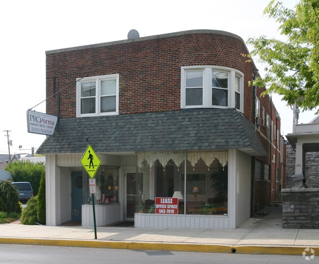
Property Record
17 E Main St, Hummelstown, PA 17036
NEARBY LISTINGS FOR SALE OR LEASE
Property Detail
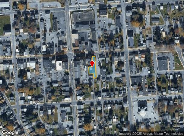
17 E Main St
Commercialofficeresidentialmixeduse
Dauphin
X
Pennsylvania
42043C0364D
0.20 AC
2025
Harrisburg Area East
2025
Philadelphia
024400
Harrisburg-Carlisle, PA
5,994 SF
31-027-015
DEMOGRAPHICS near 17 E Main St
1 mile
3 mile
5 mile
2024 Total Population
5,426
30,806
84,532
2029 Population
5,522
31,296
86,087
Pop Growth 2024-2029
+ 1.77%
+ 1.59%
+ 1.84%
Average Age
41
40
41
2024 Total Households
2,463
12,601
33,800
HH Growth 2024-2029
+ 1.99%
+ 1.70%
+ 1.94%
Median Household Inc
$67,858
$83,862
$83,836
Avg Household Size
2.20
2.40
2.40
2024 Avg HH Vehicles
2.00
2.00
2.00
Median Home Value
$246,243
$278,848
$248,710
Median Year Built
1967
1981
1981
Nearby Places
Map Layers
Map Styles
 Street
 Aerial
Transit
 Traffic
 Biking
Places
Listings with unknown addresses are not visible on the map
- Restaurants
- Banks
- Shops
- Fitness
- Groceries
PUBLIC TRANSPORTATION
COMMUTER RAIL
Middletown (Keystone Service - Amtrak)
Drive
Walk
Distance
Middletown (Keystone Service - Amtrak)
13 min
6.1 mi
AIRPORT
Harrisburg International
Drive
Walk
Distance
Harrisburg International
16 min
8.3 mi
Freight Ports
Port of Baltimore
Drive
Walk
Distance
Port of Baltimore
120 min
89.2 mi
SALE & LEASE HISTORY
LISTING DATE
SALE/LEASE

Mar 13, 2024
For Sale
Jan 16, 2018
For Lease
Dec 26, 2017
For Lease
Nearby Properties
Address
Land Use
TOTAL SIZE
Lot Size
Zoning
Address
Land Use
TOTAL SIZE
Lot Size
Zoning
1,414,742 SF
216.49 AC
Address
Land Use
TOTAL SIZE
Lot Size
Zoning
57,016 SF
43.70 AC
Address
Land Use
TOTAL SIZE
Lot Size
Zoning
1,619 SF
125.81 AC
Address
Land Use
TOTAL SIZE
Lot Size
Zoning
4,176 SF
192.96 AC
Address
Land Use
TOTAL SIZE
Lot Size
Zoning
188,919 SF
193.39 AC
Address
Land Use
TOTAL SIZE
Lot Size
Zoning
19.61 AC
Address
Land Use
TOTAL SIZE
Lot Size
Zoning
3,135 SF
51.95 AC
Address
Land Use
TOTAL SIZE
Lot Size
Zoning
50,963 SF
46.61 AC
Address
Land Use
TOTAL SIZE
Lot Size
Zoning
211,430 SF
38.50 AC
Address
Land Use
TOTAL SIZE
Lot Size
Zoning
9,335 SF
39.62 AC
Address
Land Use
TOTAL SIZE
Lot Size
Zoning
651,250 SF
47.13 AC
Address
Land Use
TOTAL SIZE
Lot Size
Zoning
1,196 SF
50.34 AC
Address
Land Use
TOTAL SIZE
Lot Size
Zoning
3,232 SF
38.86 AC
Address
Land Use
TOTAL SIZE
Lot Size
Zoning
239,046 SF
23 AC
Address
Land Use
TOTAL SIZE
Lot Size
Zoning
102,456 SF
9.84 AC
Address
Land Use
TOTAL SIZE
Lot Size
Zoning
507,000 SF
32.82 AC
Address
Land Use
TOTAL SIZE
Lot Size
Zoning
121,119 SF
17.01 AC
Address
Land Use
TOTAL SIZE
Lot Size
Zoning
95,192 SF
52.43 AC
Address
Land Use
TOTAL SIZE
Lot Size
Zoning
348,615 SF
38.98 AC
Address
Land Use
TOTAL SIZE
Lot Size
Zoning
18.43 AC
Address
Land Use
TOTAL SIZE
Lot Size
Zoning
77,280 SF
9.60 AC
Address
Land Use
TOTAL SIZE
Lot Size
Zoning
196,000 SF
12.42 AC
Address
Land Use
TOTAL SIZE
Lot Size
Zoning
249,112 SF
24.01 AC
Address
Land Use
TOTAL SIZE
Lot Size
Zoning
59,760 SF
61.67 AC
Address
Land Use
TOTAL SIZE
Lot Size
Zoning
170.34 AC
Address
Land Use
TOTAL SIZE
Lot Size
Zoning
3,698 SF
250.35 AC
Address
Land Use
TOTAL SIZE
Lot Size
Zoning
186,000 SF
10.58 AC
Address
Land Use
TOTAL SIZE
Lot Size
Zoning
67,968 SF
13.34 AC
Address
Land Use
TOTAL SIZE
Lot Size
Zoning
105,650 SF
8.44 AC
Address
Land Use
TOTAL SIZE
Lot Size
Zoning
79,302 SF
19.64 AC
The World's #1 Commercial Real Estate Marketplace
Connect with us
© 2026 CoStar Group
The information above has been obtained from sources believed reliable. While we do not doubt its accuracy we have not verified it and make no guarantee, warranty or representation about it. It is your responsibility to independently confirm its accuracy and completeness. Any projections, opinions, assumptions, or estimates used are for example only and do not represent the current or future performance of the property. The value of this transaction to you depends on tax and other factors which should be evaluated by your tax, financial, and legal advisors. You and your advisors should conduct a careful, independent investigation of the property to determine to your satisfaction the suitability of the property for your needs.