Property Record
17 East St, Easthampton, MA 01027
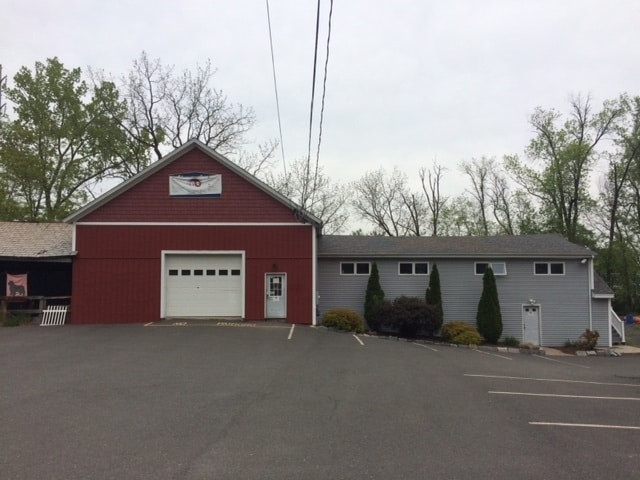

Property Detail
17 East St
EHAM-000110-000010
Hampshire
Departmentstore
Massachusetts
HB
0.87 AC
2025
Hampshire County
2025
Hartford
822300
Amherst Town-Northampton, MA
3,946 SF
NEARBY LISTINGS FOR SALE OR LEASE
DEMOGRAPHICS near 17 East St
1 mile
3 mile
5 mile
2025 Total Population
295
23,318
66,388
2030 Population
293
23,262
66,089
Pop Growth 2025-2030
(0.68%)
(0.24%)
(0.45%)
Average Age
44
41
43
2025 Total Households
133
10,334
28,103
HH Growth 2025-2030
(0.75%)
(0.36%)
(0.48%)
Median Household Inc
$67,894
$67,515
$77,280
Avg Household Size
2.20
2.00
2.10
2025 Avg HH Vehicles
2.00
1.00
2.00
Median Home Value
$386,956
$411,083
$381,184
Median Year Built
1948
1949
1958
Nearby Places
Map Layers
Map Styles
 Street
 Aerial
Layers
 Traffic
 Biking
Places
Listings with unknown addresses are not visible on the map
- Restaurants
- Banks
- Shops
- Fitness
- Groceries
PUBLIC TRANSPORTATION
COMMUTER RAIL
Drive
Walk
Distance
5 min
2.5 mi
Drive
Walk
Distance
13 min
7.7 mi
AIRPORT
Bradley International
Drive
Walk
Distance
Bradley International
51 min
27.1 mi
SALE & LEASE HISTORY
LISTING DATE
SALE/LEASE

Sep 25, 2016
For Lease
Nearby Properties
Address
Land Use
TOTAL SIZE
Lot Size
Zoning
Address
Land Use
TOTAL SIZE
Lot Size
Zoning
5.65 AC
URC
Address
Land Use
TOTAL SIZE
Lot Size
Zoning
5.84 AC
URC
Address
Land Use
TOTAL SIZE
Lot Size
Zoning
17.40 AC
SC
Address
Land Use
TOTAL SIZE
Lot Size
Zoning
150,256 SF
13.58 AC
Address
Land Use
TOTAL SIZE
Lot Size
Zoning
29.13 AC
RR
Address
Land Use
TOTAL SIZE
Lot Size
Zoning
4,114 SF
125.44 AC
R35
Address
Land Use
TOTAL SIZE
Lot Size
Zoning
0.12 AC
URC
Address
Land Use
TOTAL SIZE
Lot Size
Zoning
55,964 SF
0.36 AC
URC
Address
Land Use
TOTAL SIZE
Lot Size
Zoning
2.69 AC
URC
Address
Land Use
TOTAL SIZE
Lot Size
Zoning
1.77 AC
URC
Address
Land Use
TOTAL SIZE
Lot Size
Zoning
88,144 SF
0.35 AC
CB
Address
Land Use
TOTAL SIZE
Lot Size
Zoning
1.47 AC
URC
Address
Land Use
TOTAL SIZE
Lot Size
Zoning
85,816 SF
6.80 AC
URB
Address
Land Use
TOTAL SIZE
Lot Size
Zoning
98,482 SF
1.03 AC
CB
Address
Land Use
TOTAL SIZE
Lot Size
Zoning
2.51 AC
URC
Address
Land Use
TOTAL SIZE
Lot Size
Zoning
13,608 SF
11 AC
RR
Address
Land Use
TOTAL SIZE
Lot Size
Zoning
80,161 SF
2.08 AC
URC
Address
Land Use
TOTAL SIZE
Lot Size
Zoning
45,480 SF
3.48 AC
GB
Address
Land Use
TOTAL SIZE
Lot Size
Zoning
2.51 AC
URC
Address
Land Use
TOTAL SIZE
Lot Size
Zoning
162,055 SF
2.92 AC
CB
Address
Land Use
TOTAL SIZE
Lot Size
Zoning
0.14 AC
URC
Address
Land Use
TOTAL SIZE
Lot Size
Zoning
8.13 AC
BP
Address
Land Use
TOTAL SIZE
Lot Size
Zoning
32,187 SF
3.16 AC
HB
Address
Land Use
TOTAL SIZE
Lot Size
Zoning
3.13 AC
URC
Address
Land Use
TOTAL SIZE
Lot Size
Zoning
39,110 SF
3.62 AC
GB
Address
Land Use
TOTAL SIZE
Lot Size
Zoning
47,600 SF
1.39 AC
URC
Address
Land Use
TOTAL SIZE
Lot Size
Zoning
1.37 AC
URC
Address
Land Use
TOTAL SIZE
Lot Size
Zoning
16,720 SF
5.74 AC
HB
Address
Land Use
TOTAL SIZE
Lot Size
Zoning
1.75 AC
CB
Address
Land Use
TOTAL SIZE
Lot Size
Zoning
2.01 AC
URC
The World's #1 Commercial Real Estate Marketplace
Connect with us
© 2026 CoStar Group
The information above has been obtained from sources believed reliable. While we do not doubt its accuracy we have not verified it and make no guarantee, warranty or representation about it. It is your responsibility to independently confirm its accuracy and completeness. Any projections, opinions, assumptions, or estimates used are for example only and do not represent the current or future performance of the property. The value of this transaction to you depends on tax and other factors which should be evaluated by your tax, financial, and legal advisors. You and your advisors should conduct a careful, independent investigation of the property to determine to your satisfaction the suitability of the property for your needs.