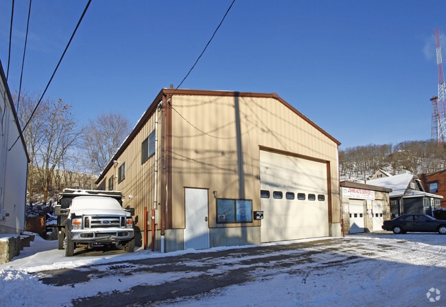
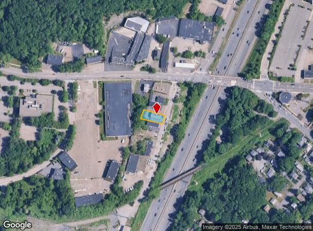
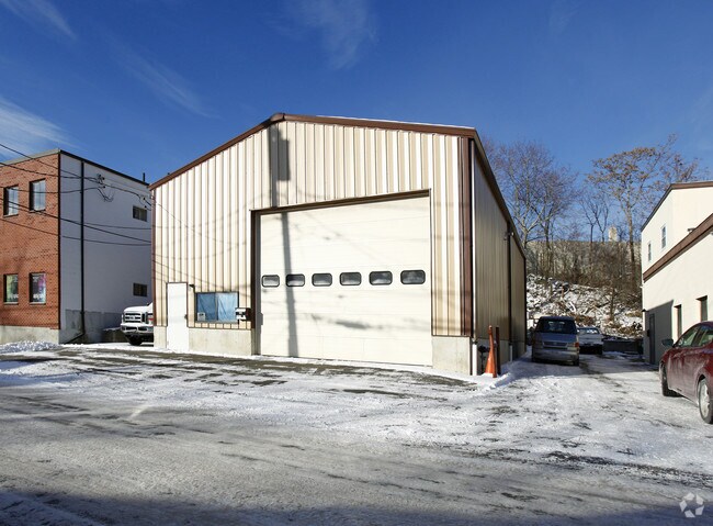
Property Record
17 Green St, Waltham, MA 02451
NEARBY LISTINGS FOR SALE OR LEASE
Property Detail
17 Green St
WALT-000057-000015-000004
Middlesex
Commercialbuilding
Massachusetts
X
4
25017C0394F
0.13 AC
2025
Waltham/Watertown
2025
Boston
368200
Boston-Cambridge-Newton, MA-NH
1,960 SF
DEMOGRAPHICS near 17 Green St
1 Mile
3 Mile
5 Mile
2024 Total Population
6,681
80,439
212,403
2029 Population
6,568
79,440
210,100
Pop Growth 2024-2029
(1.69%)
(1.24%)
(1.08%)
Average Age
40
40
41
2024 Total Households
2,699
31,902
80,729
HH Growth 2024-2029
(1.70%)
(1.35%)
(1.22%)
Median Household Inc
$110,531
$116,990
$140,320
Avg Household Size
2.40
2.40
2.50
2024 Avg HH Vehicles
2.00
2.00
2.00
Median Home Value
$734,223
$806,465
$930,757
Median Year Built
1953
1956
1953
Nearby Places
Map Layers
Map Styles
 Street
 Aerial
- Restaurants
- Banks
- Shops
- Fitness
- Groceries
PUBLIC TRANSPORTATION
TRANSIT/SUBWAY
Kendal Green (Fitchburg/South Acton Line - Massachusetts Bay Transportation Authority Commuter Rail (Purple Line))
DRIVE
WALK
Distance
Kendal Green (Fitchburg/South Acton Line - Massachusetts Bay Transportation Authority Commuter Rail (Purple Line))
2 min
18 min
0.9 mi
COMMUTER RAIL
Kendal Green (Fitchburg/South Acton Line - Massachusetts Bay Transportation Authority Commuter Rail (Purple Line))
DRIVE
WALK
Distance
Kendal Green (Fitchburg/South Acton Line - Massachusetts Bay Transportation Authority Commuter Rail (Purple Line))
2 min
18 min
0.9 mi
DRIVE
WALK
Distance
4 min
1.8 mi
AIRPORT
General Edward Lawrence Logan International
DRIVE
WALK
Distance
General Edward Lawrence Logan International
28 min
15.6 mi
Worcester Regional
DRIVE
WALK
Distance
Worcester Regional
58 min
40.4 mi
Nearby Properties
Address
Land Use
TOTAL SIZE
Lot Size
Zoning
Address
Land Use
TOTAL SIZE
Lot Size
Zoning
776,099 SF
35.70 AC
Address
Land Use
TOTAL SIZE
Lot Size
Zoning
447,312 SF
62.01 AC
Address
Land Use
TOTAL SIZE
Lot Size
Zoning
561,437 SF
33.53 AC
Address
Land Use
TOTAL SIZE
Lot Size
Zoning
165,986 SF
4.32 AC
Address
Land Use
TOTAL SIZE
Lot Size
Zoning
105,982 SF
4.50 AC
Address
Land Use
TOTAL SIZE
Lot Size
Zoning
387,965 SF
3.90 AC
Address
Land Use
TOTAL SIZE
Lot Size
Zoning
21.52 AC
Address
Land Use
TOTAL SIZE
Lot Size
Zoning
317,256 SF
17.48 AC
Address
Land Use
TOTAL SIZE
Lot Size
Zoning
336,306 SF
7.54 AC
Address
Land Use
TOTAL SIZE
Lot Size
Zoning
234,814 SF
4.06 AC
Address
Land Use
TOTAL SIZE
Lot Size
Zoning
293,084 SF
5.01 AC
1
Address
Land Use
TOTAL SIZE
Lot Size
Zoning
238,065 SF
1.79 AC
Address
Land Use
TOTAL SIZE
Lot Size
Zoning
272,445 SF
6.40 AC
Address
Land Use
TOTAL SIZE
Lot Size
Zoning
118,696 SF
65.79 AC
A
Address
Land Use
TOTAL SIZE
Lot Size
Zoning
282,014 SF
15.57 AC
Address
Land Use
TOTAL SIZE
Lot Size
Zoning
269,692 SF
15.37 AC
Address
Land Use
TOTAL SIZE
Lot Size
Zoning
402,419 SF
73.98 AC
BB
Address
Land Use
TOTAL SIZE
Lot Size
Zoning
344,469 SF
54.49 AC
Address
Land Use
TOTAL SIZE
Lot Size
Zoning
6.51 AC
PSCD
Address
Land Use
TOTAL SIZE
Lot Size
Zoning
293,195 SF
11.55 AC
BU5
Address
Land Use
TOTAL SIZE
Lot Size
Zoning
391,781 SF
8.22 AC
Address
Land Use
TOTAL SIZE
Lot Size
Zoning
3.86 AC
Address
Land Use
TOTAL SIZE
Lot Size
Zoning
442,743 SF
27.11 AC
Address
Land Use
TOTAL SIZE
Lot Size
Zoning
164,072 SF
43.80 AC
Address
Land Use
TOTAL SIZE
Lot Size
Zoning
212,684 SF
54.49 AC
Address
Land Use
TOTAL SIZE
Lot Size
Zoning
30.69 AC
Address
Land Use
TOTAL SIZE
Lot Size
Zoning
21.99 AC
Address
Land Use
TOTAL SIZE
Lot Size
Zoning
124,950 SF
1.69 AC
Address
Land Use
TOTAL SIZE
Lot Size
Zoning
224,892 SF
20.52 AC
Address
Land Use
TOTAL SIZE
Lot Size
Zoning
286,462 SF
15.94 AC
The World's #1 Commercial Real Estate Marketplace
Connect with us
© 2025 CoStar Group
The information above has been obtained from sources believed reliable. While we do not doubt its accuracy we have not verified it and make no guarantee, warranty or representation about it. It is your responsibility to independently confirm its accuracy and completeness. Any projections, opinions, assumptions, or estimates used are for example only and do not represent the current or future performance of the property. The value of this transaction to you depends on tax and other factors which should be evaluated by your tax, financial, and legal advisors. You and your advisors should conduct a careful, independent investigation of the property to determine to your satisfaction the suitability of the property for your needs.