Property Record
17 Llanfair Rd, Ardmore, PA 19003
NEARBY LISTINGS FOR SALE OR LEASE
Property Detail
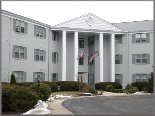
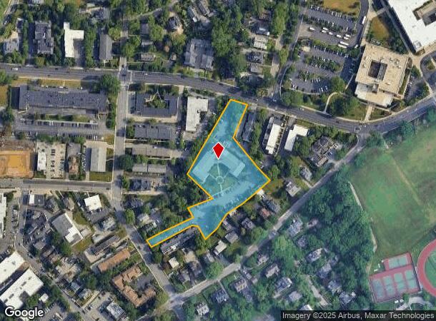
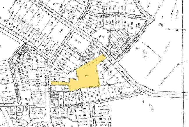
17 Llanfair Rd
Philadelphia-Camden-Wilmington, PA-NJ-DE-MD
Llanfair House
40-00-38368-004
ASSESSOR BLOCK-UNIT NUMBER 5C-88
Apartment
Montgomery
X
Pennsylvania
42091C0368G
88
2024
1.87 AC
2025
Ardmore
205402
Philadelphia
57,140 SF
DEMOGRAPHICS near 17 Llanfair Rd
1 Mile
3 Mile
5 Mile
2024 Total Population
18,035
138,409
444,844
2029 Population
18,446
138,430
439,928
Pop Growth 2024-2029
+ 2.28%
+ 0.02%
(1.11%)
Average Age
41
40
39
2024 Total Households
7,600
51,615
176,200
HH Growth 2024-2029
+ 2.45%
(0.07%)
(1.26%)
Median Household Inc
$130,183
$111,780
$72,462
Avg Household Size
2.30
2.50
2.40
2024 Avg HH Vehicles
2.00
2.00
1.00
Median Home Value
$652,578
$440,773
$294,169
Median Year Built
1949
1949
1949
Nearby Places
Map Layers
Map Styles
 Street
 Aerial
- Restaurants
- Banks
- Shops
- Fitness
- Groceries
PUBLIC TRANSPORTATION
COMMUTER RAIL
Ardmore (R5 - Southeastern Pennsylvania Transportation Authority Regional Rail (SEPTA Regional Rail))
DRIVE
WALK
Distance
Ardmore (R5 - Southeastern Pennsylvania Transportation Authority Regional Rail (SEPTA Regional Rail))
2 min
10 min
0.5 mi
Wynnewood (R5 - Southeastern Pennsylvania Transportation Authority Regional Rail (SEPTA Regional Rail))
DRIVE
WALK
Distance
Wynnewood (R5 - Southeastern Pennsylvania Transportation Authority Regional Rail (SEPTA Regional Rail))
3 min
16 min
0.9 mi
AIRPORT
Philadelphia International
DRIVE
WALK
Distance
Philadelphia International
31 min
12.1 mi
Freight Ports
South Jersey Port
DRIVE
WALK
Distance
South Jersey Port
26 min
12.7 mi
Nearby Properties
Address
Land Use
TOTAL SIZE
Lot Size
Zoning
Address
Land Use
TOTAL SIZE
Lot Size
Zoning
2,178,860 SF
48.65 AC
R3
Address
Land Use
TOTAL SIZE
Lot Size
Zoning
59,126 SF
84.57 AC
Address
Land Use
TOTAL SIZE
Lot Size
Zoning
1,600 SF
177.07 AC
SPPOA
Address
Land Use
TOTAL SIZE
Lot Size
Zoning
1,174,127 SF
2 AC
C1
Address
Land Use
TOTAL SIZE
Lot Size
Zoning
1,037,806 SF
73.69 AC
R2
Address
Land Use
TOTAL SIZE
Lot Size
Zoning
511,806 SF
1.70 AC
RM4
Address
Land Use
TOTAL SIZE
Lot Size
Zoning
702,393 SF
61.81 AC
RA
Address
Land Use
TOTAL SIZE
Lot Size
Zoning
409,386 SF
33.36 AC
R2
Address
Land Use
TOTAL SIZE
Lot Size
Zoning
479,520 SF
21.26 AC
R1
Address
Land Use
TOTAL SIZE
Lot Size
Zoning
377,851 SF
19.18 AC
R4
Address
Land Use
TOTAL SIZE
Lot Size
Zoning
112,268 SF
28.27 AC
Address
Land Use
TOTAL SIZE
Lot Size
Zoning
281,508 SF
18.93 AC
SPINS
Address
Land Use
TOTAL SIZE
Lot Size
Zoning
299,678 SF
14.06 AC
R4
Address
Land Use
TOTAL SIZE
Lot Size
Zoning
530,525 SF
36.29 AC
R3
Address
Land Use
TOTAL SIZE
Lot Size
Zoning
73,193 SF
37.01 AC
Address
Land Use
TOTAL SIZE
Lot Size
Zoning
82,153 SF
13.97 AC
Address
Land Use
TOTAL SIZE
Lot Size
Zoning
257,405 SF
4.26 AC
C2
Address
Land Use
TOTAL SIZE
Lot Size
Zoning
561,359 SF
48.06 AC
R1
Address
Land Use
TOTAL SIZE
Lot Size
Zoning
321,744 SF
14 AC
C1
Address
Land Use
TOTAL SIZE
Lot Size
Zoning
521,041 SF
28.14 AC
I2
Address
Land Use
TOTAL SIZE
Lot Size
Zoning
93,353 SF
1.03 AC
CMX2.5
Address
Land Use
TOTAL SIZE
Lot Size
Zoning
78,250 SF
34.50 AC
Address
Land Use
TOTAL SIZE
Lot Size
Zoning
252,350 SF
0.91 AC
SPINS
Address
Land Use
TOTAL SIZE
Lot Size
Zoning
4,350 SF
20 AC
Address
Land Use
TOTAL SIZE
Lot Size
Zoning
114,058 SF
3.20 AC
Address
Land Use
TOTAL SIZE
Lot Size
Zoning
746,701 SF
71.71 AC
R3
Address
Land Use
TOTAL SIZE
Lot Size
Zoning
149,040 SF
7.78 AC
Address
Land Use
TOTAL SIZE
Lot Size
Zoning
248,747 SF
34.20 AC
R1
Address
Land Use
TOTAL SIZE
Lot Size
Zoning
112,597 SF
6.47 AC
C2
Address
Land Use
TOTAL SIZE
Lot Size
Zoning
338,088 SF
9.82 AC
R7
The World's #1 Commercial Real Estate Marketplace
Connect with us
© 2025 CoStar Group
The information above has been obtained from sources believed reliable. While we do not doubt its accuracy we have not verified it and make no guarantee, warranty or representation about it. It is your responsibility to independently confirm its accuracy and completeness. Any projections, opinions, assumptions, or estimates used are for example only and do not represent the current or future performance of the property. The value of this transaction to you depends on tax and other factors which should be evaluated by your tax, financial, and legal advisors. You and your advisors should conduct a careful, independent investigation of the property to determine to your satisfaction the suitability of the property for your needs.