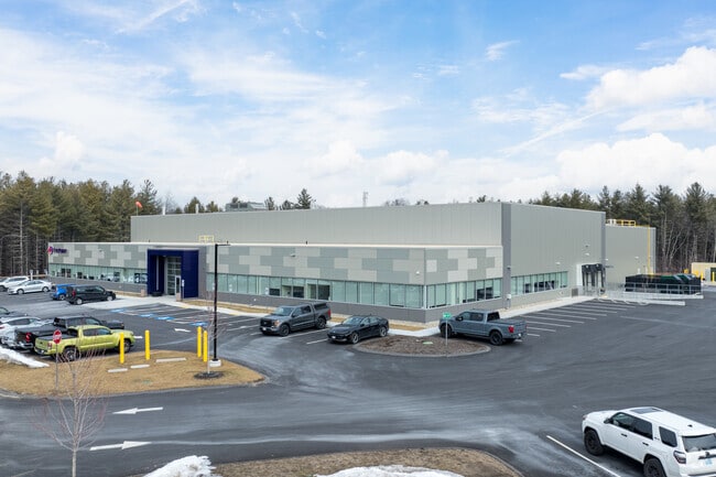
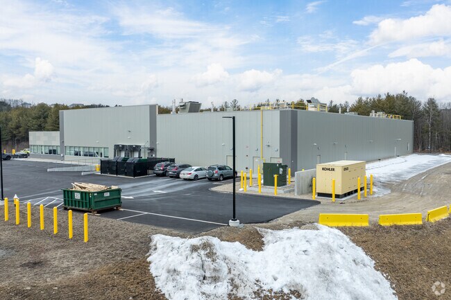
Property Record
17 Main St, Douglas, MA 01516

Property Detail
17 Main St
DOUG-000198-000005
WORCESTER
Governmentalpublicusegeneral
Massachusetts
RC-1
0.84 AC
A Areas with a 1% annual chance of flooding and a 26% chance of flooding over the life of a 30-year mortgage.
Outlying Worcester
2025
Boston
2025
Worcester, MA
752101
NEARBY LISTINGS FOR SALE OR LEASE
-
-
View all Douglas listings for sale on LoopNet.com
DEMOGRAPHICS near 17 Main St
1 mile
3 mile
5 mile
2025 Total Population
1,573
24,278
53,182
2030 Population
1,636
24,977
54,692
Pop Growth 2025-2030
+ 4.01%
+ 2.88%
+ 2.84%
Average Age
43
43
42
2025 Total Households
645
9,523
20,325
HH Growth 2025-2030
+ 4.03%
+ 2.92%
+ 2.91%
Median Household Inc
$94,470
$112,548
$123,155
Avg Household Size
2.40
2.50
2.60
2025 Avg HH Vehicles
2.00
2.00
2.00
Median Home Value
$387,999
$467,104
$493,316
Median Year Built
1974
1974
1978
Nearby Places
Map Layers
Map Styles
 Street
 Aerial
Layers
 Traffic
 Biking
Places
Listings with unknown addresses are not visible on the map
- Restaurants
- Banks
- Shops
- Fitness
- Groceries
PUBLIC TRANSPORTATION
AIRPORT
Worcester Regional
Drive
Walk
Distance
Worcester Regional
36 min
22.6 mi
Rhode Island Tf Green International
Drive
Walk
Distance
Rhode Island Tf Green International
52 min
36.5 mi
Freight Ports
Port of Davisville, RI
Drive
Walk
Distance
Port of Davisville, RI
66 min
48.4 mi
Nearby Properties
Address
Land Use
TOTAL SIZE
Lot Size
Zoning
Address
Land Use
TOTAL SIZE
Lot Size
Zoning
134,096 SF
61.68 AC
C
Address
Land Use
TOTAL SIZE
Lot Size
Zoning
6,743 SF
7.12 AC
IND
Address
Land Use
TOTAL SIZE
Lot Size
Zoning
216,167 SF
26.06 AC
C
Address
Land Use
TOTAL SIZE
Lot Size
Zoning
312,077 SF
13.66 AC
C
Address
Land Use
TOTAL SIZE
Lot Size
Zoning
32,156 SF
3.59 AC
VR
Address
Land Use
TOTAL SIZE
Lot Size
Zoning
134,072 SF
8.27 AC
VB
Address
Land Use
TOTAL SIZE
Lot Size
Zoning
87.37 AC
IND
Address
Land Use
TOTAL SIZE
Lot Size
Zoning
30,742 SF
5.42 AC
CB
Address
Land Use
TOTAL SIZE
Lot Size
Zoning
11.22 AC
V
Address
Land Use
TOTAL SIZE
Lot Size
Zoning
12,023 SF
10.31 AC
VB
Address
Land Use
TOTAL SIZE
Lot Size
Zoning
25,347 SF
30.72 AC
RA
Address
Land Use
TOTAL SIZE
Lot Size
Zoning
16,302 SF
1.85 AC
VR
Address
Land Use
TOTAL SIZE
Lot Size
Zoning
10,634 SF
0.77 AC
VR
Address
Land Use
TOTAL SIZE
Lot Size
Zoning
10,333 SF
41.91 AC
IND
Address
Land Use
TOTAL SIZE
Lot Size
Zoning
13,833 SF
1.39 AC
VB
Address
Land Use
TOTAL SIZE
Lot Size
Zoning
854 SF
72.35 AC
RA
Address
Land Use
TOTAL SIZE
Lot Size
Zoning
9,270 SF
0.72 AC
VB
Address
Land Use
TOTAL SIZE
Lot Size
Zoning
7,072 SF
3.40 AC
C
Address
Land Use
TOTAL SIZE
Lot Size
Zoning
9,234 SF
1.32 AC
VR
Address
Land Use
TOTAL SIZE
Lot Size
Zoning
10,762 SF
0.71 AC
VB
Address
Land Use
TOTAL SIZE
Lot Size
Zoning
3,360 SF
0.81 AC
C
Address
Land Use
TOTAL SIZE
Lot Size
Zoning
8,688 SF
2.15 AC
IND
Address
Land Use
TOTAL SIZE
Lot Size
Zoning
11,832 SF
2.13 AC
VR
Address
Land Use
TOTAL SIZE
Lot Size
Zoning
6,080 SF
1.16 AC
C
Address
Land Use
TOTAL SIZE
Lot Size
Zoning
13,580 SF
1.89 AC
IND
Address
Land Use
TOTAL SIZE
Lot Size
Zoning
8,140 SF
3.58 AC
C
Address
Land Use
TOTAL SIZE
Lot Size
Zoning
4,861 SF
9.03 AC
SFOS
Address
Land Use
TOTAL SIZE
Lot Size
Zoning
2.33 AC
RA
Address
Land Use
TOTAL SIZE
Lot Size
Zoning
9.39 AC
R1
Address
Land Use
TOTAL SIZE
Lot Size
Zoning
19,544 SF
2.59 AC
IND
The World's #1 Commercial Real Estate Marketplace
Connect with us
© 2026 CoStar Group
The information above has been obtained from sources believed reliable. While we do not doubt its accuracy we have not verified it and make no guarantee, warranty or representation about it. It is your responsibility to independently confirm its accuracy and completeness. Any projections, opinions, assumptions, or estimates used are for example only and do not represent the current or future performance of the property. The value of this transaction to you depends on tax and other factors which should be evaluated by your tax, financial, and legal advisors. You and your advisors should conduct a careful, independent investigation of the property to determine to your satisfaction the suitability of the property for your needs.