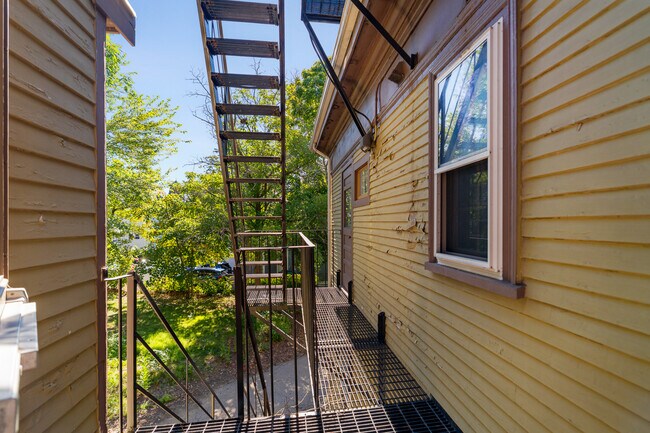
Property Record
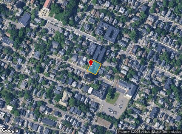
17 Monmouth St, Somerville, MA 02143
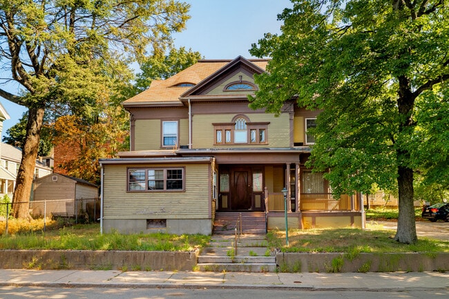
This Property Is For Sale
NEARBY LISTINGS FOR SALE OR LEASE
Property Detail
17 Monmouth St
SOME-000044-C000000-000014
Middlesex
Governmentalpublicusegeneral
Massachusetts
X
14
25017C0438F
0.27 AC
0
Spring Hill
2025
Boston
351102
Boston-Cambridge-Newton, MA-NH
4,154 SF
DEMOGRAPHICS near 17 Monmouth St
1 Mile
3 Mile
5 Mile
2024 Total Population
69,132
433,271
1,013,948
2029 Population
70,564
447,238
1,042,909
Pop Growth 2024-2029
+ 2.07%
+ 3.22%
+ 2.86%
Average Age
36
36
37
2024 Total Households
29,802
186,498
420,114
HH Growth 2024-2029
+ 2.35%
+ 3.64%
+ 3.23%
Median Household Inc
$127,528
$117,602
$110,794
Avg Household Size
2.10
2.10
2.20
2024 Avg HH Vehicles
1.00
1.00
1.00
Median Home Value
$980,777
$922,032
$874,374
Median Year Built
1946
1949
1949
Nearby Places
- Restaurants
- Banks
- Shops
- Fitness
- Groceries
PUBLIC TRANSPORTATION
TRANSIT/SUBWAY
Gilman Square (Green Line B - MBTA, Green Line C - MBTA, Green Line D - MBTA, Green Line E - MBTA)
DRIVE
WALK
Distance
Gilman Square (Green Line B - MBTA, Green Line C - MBTA, Green Line D - MBTA, Green Line E - MBTA)
2 min
14 min
0.7 mi
Magoun Square (Green Line B - MBTA, Green Line C - MBTA, Green Line D - MBTA, Green Line E - MBTA)
DRIVE
WALK
Distance
Magoun Square (Green Line B - MBTA, Green Line C - MBTA, Green Line D - MBTA, Green Line E - MBTA)
3 min
14 min
0.7 mi
Porter Square Station (Red Line - Massachusetts Bay Transportation Authority Subway (The T))
DRIVE
WALK
Distance
Porter Square Station (Red Line - Massachusetts Bay Transportation Authority Subway (The T))
2 min
16 min
0.8 mi
Union Square (Green Line D - MBTA)
DRIVE
WALK
Distance
Union Square (Green Line D - MBTA)
4 min
20 min
1.1 mi
COMMUTER RAIL
Porter Square (Fitchburg/South Acton Line - Massachusetts Bay Transportation Authority Commuter Rail (Purple Line))
DRIVE
WALK
Distance
Porter Square (Fitchburg/South Acton Line - Massachusetts Bay Transportation Authority Commuter Rail (Purple Line))
3 min
16 min
0.9 mi
Boston Landing (Framingham/Worcester Line - MBTA)
DRIVE
WALK
Distance
Boston Landing (Framingham/Worcester Line - MBTA)
18 min
8.4 mi
AIRPORT
General Edward Lawrence Logan International
DRIVE
WALK
Distance
General Edward Lawrence Logan International
14 min
6.3 mi
Freight Ports
Port of Boston
DRIVE
WALK
Distance
Port of Boston
15 min
6.0 mi
Nearby Properties
Address
Land Use
TOTAL SIZE
Lot Size
Zoning
Address
Land Use
TOTAL SIZE
Lot Size
Zoning
610,560 SF
4.01 AC
E
Address
Land Use
TOTAL SIZE
Lot Size
Zoning
439,500 SF
9.21 AC
E
Address
Land Use
TOTAL SIZE
Lot Size
Zoning
125,571 SF
3.25 AC
C-3
Address
Land Use
TOTAL SIZE
Lot Size
Zoning
6.39 AC
C
Address
Land Use
TOTAL SIZE
Lot Size
Zoning
530,200 SF
62.08 AC
E
Address
Land Use
TOTAL SIZE
Lot Size
Zoning
173,400 SF
1.14 AC
MXD
Address
Land Use
TOTAL SIZE
Lot Size
Zoning
142,458 SF
1.67 AC
C-3
Address
Land Use
TOTAL SIZE
Lot Size
Zoning
334,522 SF
1.26 AC
C
Address
Land Use
TOTAL SIZE
Lot Size
Zoning
230,394 SF
0.60 AC
MXD
Address
Land Use
TOTAL SIZE
Lot Size
Zoning
46,259 SF
1.05 AC
E
Address
Land Use
TOTAL SIZE
Lot Size
Zoning
304,349 SF
1.72 AC
Address
Land Use
TOTAL SIZE
Lot Size
Zoning
3.52 AC
C-3
Address
Land Use
TOTAL SIZE
Lot Size
Zoning
1.13 AC
C
Address
Land Use
TOTAL SIZE
Lot Size
Zoning
239,377 SF
0.71 AC
MXD
Address
Land Use
TOTAL SIZE
Lot Size
Zoning
419,722 SF
2.03 AC
RC
Address
Land Use
TOTAL SIZE
Lot Size
Zoning
283,554 SF
2.76 AC
O-2A
Address
Land Use
TOTAL SIZE
Lot Size
Zoning
54,500 SF
4.01 AC
O-2A
Address
Land Use
TOTAL SIZE
Lot Size
Zoning
2.81 AC
O-2
Address
Land Use
TOTAL SIZE
Lot Size
Zoning
47.67 AC
UN
Address
Land Use
TOTAL SIZE
Lot Size
Zoning
4,355 SF
13.12 AC
E
Address
Land Use
TOTAL SIZE
Lot Size
Zoning
646,546 SF
89.28 AC
ROD
Address
Land Use
TOTAL SIZE
Lot Size
Zoning
237,935 SF
1.27 AC
C-3
Address
Land Use
TOTAL SIZE
Lot Size
Zoning
386,825 SF
10.67 AC
Address
Land Use
TOTAL SIZE
Lot Size
Zoning
6.14 AC
C
Address
Land Use
TOTAL SIZE
Lot Size
Zoning
157,083 SF
0.41 AC
C
Address
Land Use
TOTAL SIZE
Lot Size
Zoning
2.87 AC
O-2A
Address
Land Use
TOTAL SIZE
Lot Size
Zoning
155,818 SF
5.33 AC
OS
Address
Land Use
TOTAL SIZE
Lot Size
Zoning
506,534 SF
2.75 AC
C
Address
Land Use
TOTAL SIZE
Lot Size
Zoning
213,834 SF
1.48 AC
SD-4
Address
Land Use
TOTAL SIZE
Lot Size
Zoning
136,025 SF
6.91 AC
C3
The World's #1 Commercial Real Estate Marketplace
Connect with us
© 2025 CoStar Group
The information above has been obtained from sources believed reliable. While we do not doubt its accuracy we have not verified it and make no guarantee, warranty or representation about it. It is your responsibility to independently confirm its accuracy and completeness. Any projections, opinions, assumptions, or estimates used are for example only and do not represent the current or future performance of the property. The value of this transaction to you depends on tax and other factors which should be evaluated by your tax, financial, and legal advisors. You and your advisors should conduct a careful, independent investigation of the property to determine to your satisfaction the suitability of the property for your needs.