Property Record
17 Pleasant St, Dunstable, MA 01827

Save to a Folder
{{folder.Name}}
{{folder.ListingIds.length}} Properties
{{folder.ListingIds.length}} Property
Create a New Folder
Property Detail
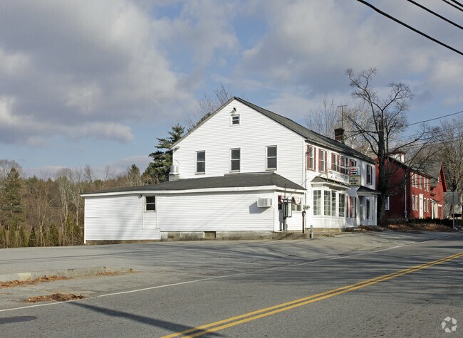
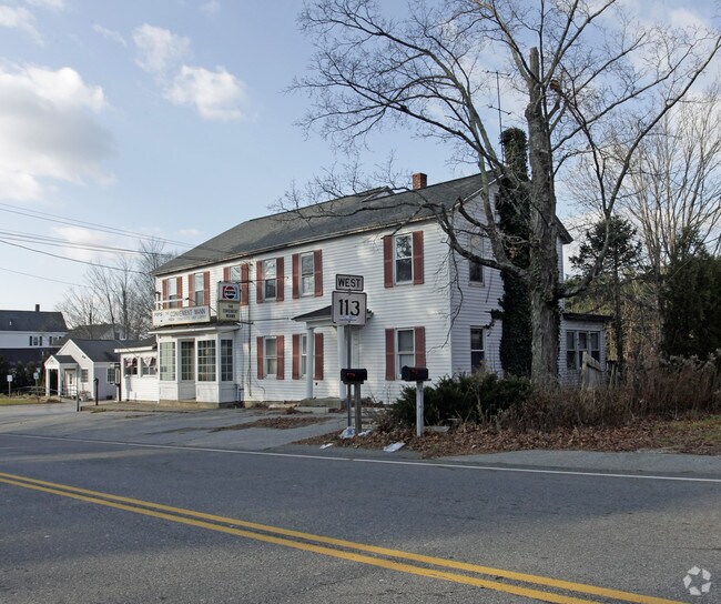
17 Pleasant St
Commercialofficeresidentialmixeduse
Middlesex
R1
Massachusetts
B and X Area of moderate flood hazard, usually the area between the limits of the 100-year and 500-year floods.
0.50 AC
2025
Groton/Townsend
2025
Boston
328100
Boston-Cambridge-Newton, MA-NH
3,452 SF
DUNS-000017-000077
NEARBY LISTINGS FOR SALE OR LEASE
DEMOGRAPHICS near 17 Pleasant St
1 mile
3 mile
5 mile
2025 Total Population
893
16,611
71,248
2030 Population
927
16,976
73,055
Pop Growth 2025-2030
+ 3.81%
+ 2.20%
+ 2.54%
Average Age
43
42
43
2025 Total Households
303
6,486
27,788
HH Growth 2025-2030
+ 3.96%
+ 2.05%
+ 2.50%
Median Household Inc
$192,741
$139,561
$122,344
Avg Household Size
2.90
2.50
2.50
2025 Avg HH Vehicles
3.00
2.00
2.00
Median Home Value
$688,750
$661,256
$497,354
Median Year Built
1979
1987
1982
Nearby Places
Map Layers
Map Styles
 Street
 Aerial
Layers
 Traffic
 Biking
Places
Listings with unknown addresses are not visible on the map
- Restaurants
- Banks
- Shops
- Fitness
- Groceries
PUBLIC TRANSPORTATION
AIRPORT
Manchester Boston Regional
Drive
Walk
Distance
Manchester Boston Regional
37 min
21.5 mi
General Edward Lawrence Logan International
Drive
Walk
Distance
General Edward Lawrence Logan International
58 min
38.0 mi
Worcester Regional
Drive
Walk
Distance
Worcester Regional
66 min
46.0 mi
Freight Ports
Port of Boston
Drive
Walk
Distance
Port of Boston
59 min
37.7 mi
Nearby Properties
Address
Land Use
TOTAL SIZE
Lot Size
Zoning
Address
Land Use
TOTAL SIZE
Lot Size
Zoning
38.17 AC
RC
Address
Land Use
TOTAL SIZE
Lot Size
Zoning
80.11 AC
PI
Address
Land Use
TOTAL SIZE
Lot Size
Zoning
52.45 AC
R18
Address
Land Use
TOTAL SIZE
Lot Size
Zoning
199.97 AC
B2
Address
Land Use
TOTAL SIZE
Lot Size
Zoning
21.17 AC
RC
Address
Land Use
TOTAL SIZE
Lot Size
Zoning
154,620 SF
8.63 AC
GB
Address
Land Use
TOTAL SIZE
Lot Size
Zoning
12.57 AC
RC
Address
Land Use
TOTAL SIZE
Lot Size
Zoning
233,668 SF
16.83 AC
PI
Address
Land Use
TOTAL SIZE
Lot Size
Zoning
144,018 SF
13.89 AC
PI
Address
Land Use
TOTAL SIZE
Lot Size
Zoning
161,790 SF
9 AC
PI
Address
Land Use
TOTAL SIZE
Lot Size
Zoning
161,790 SF
9 AC
PI
Address
Land Use
TOTAL SIZE
Lot Size
Zoning
135,324 SF
70.07 AC
R1
Address
Land Use
TOTAL SIZE
Lot Size
Zoning
120,888 SF
11.78 AC
HB
Address
Land Use
TOTAL SIZE
Lot Size
Zoning
7.21 AC
RC
Address
Land Use
TOTAL SIZE
Lot Size
Zoning
95,040 SF
7.33 AC
RC
Address
Land Use
TOTAL SIZE
Lot Size
Zoning
77,760 SF
5.76 AC
RC
Address
Land Use
TOTAL SIZE
Lot Size
Zoning
58,660 SF
6.13 AC
RC
Address
Land Use
TOTAL SIZE
Lot Size
Zoning
56,165 SF
7.25 AC
R18
Address
Land Use
TOTAL SIZE
Lot Size
Zoning
93,416 SF
4.61 AC
PI
Address
Land Use
TOTAL SIZE
Lot Size
Zoning
15.86 AC
B3
Address
Land Use
TOTAL SIZE
Lot Size
Zoning
6.64 AC
R40
Address
Land Use
TOTAL SIZE
Lot Size
Zoning
58,486 SF
1.77 AC
HB
Address
Land Use
TOTAL SIZE
Lot Size
Zoning
44,100 SF
2.72 AC
HB
Address
Land Use
TOTAL SIZE
Lot Size
Zoning
61,474 SF
11.26 AC
R18
Address
Land Use
TOTAL SIZE
Lot Size
Zoning
6.72 AC
PI
Address
Land Use
TOTAL SIZE
Lot Size
Zoning
39,464 SF
8.74 AC
B3
Address
Land Use
TOTAL SIZE
Lot Size
Zoning
64,929 SF
2.22 AC
PI
Address
Land Use
TOTAL SIZE
Lot Size
Zoning
104,996 SF
3.26 AC
GB
Address
Land Use
TOTAL SIZE
Lot Size
Zoning
42,354 SF
19.95 AC
I1
The World's #1 Commercial Real Estate Marketplace
Connect with us
© 2026 CoStar Group
The information above has been obtained from sources believed reliable. While we do not doubt its accuracy we have not verified it and make no guarantee, warranty or representation about it. It is your responsibility to independently confirm its accuracy and completeness. Any projections, opinions, assumptions, or estimates used are for example only and do not represent the current or future performance of the property. The value of this transaction to you depends on tax and other factors which should be evaluated by your tax, financial, and legal advisors. You and your advisors should conduct a careful, independent investigation of the property to determine to your satisfaction the suitability of the property for your needs.