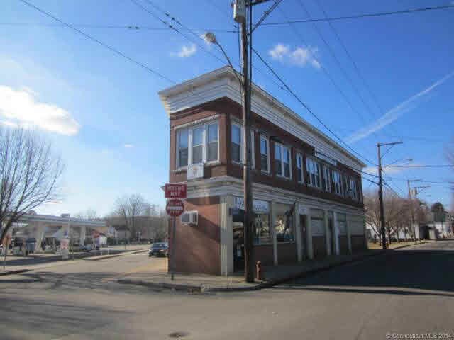
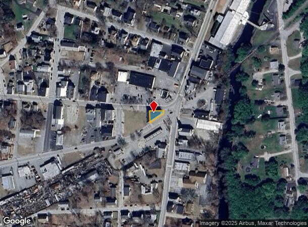
Property Record
17 Prospect St, Moosup, CT 06354
NEARBY LISTINGS FOR SALE OR LEASE
-
-
View all Moosup listings for sale on LoopNet.com
Property Detail
17 Prospect St
PLAI M:02M B:095A L:0001
Windham
Departmentstore
Connecticut
X
1
09015C0359F
0.08 AC
2024
Windham County
2025
Hartford
907200
Willimantic, CT
6,004 SF
DEMOGRAPHICS near 17 Prospect St
1 mile
3 mile
5 mile
2024 Total Population
3,293
10,151
20,347
2029 Population
3,281
10,014
20,149
Pop Growth 2024-2029
(0.36%)
(1.35%)
(0.97%)
Average Age
39
40
41
2024 Total Households
1,328
3,998
7,910
HH Growth 2024-2029
(0.30%)
(1.35%)
(0.96%)
Median Household Inc
$62,051
$73,428
$76,598
Avg Household Size
2.40
2.50
2.50
2024 Avg HH Vehicles
2.00
2.00
2.00
Median Home Value
$225,406
$229,110
$238,906
Median Year Built
1957
1970
1971
Nearby Places
Map Layers
Map Styles
 Street
 Aerial
Transit
 Traffic
 Biking
Places
Listings with unknown addresses are not visible on the map
- Restaurants
- Banks
- Shops
- Fitness
- Groceries
PUBLIC TRANSPORTATION
AIRPORT
Rhode Island Tf Green International
Drive
Walk
Distance
Rhode Island Tf Green International
48 min
35.5 mi
Freight Ports
Port of Davisville, RI
Drive
Walk
Distance
Port of Davisville, RI
60 min
34.1 mi
SALE & LEASE HISTORY
LISTING DATE
SALE/LEASE

Oct 23, 2019
For Sale
Oct 12, 2017
For Sale
Dec 09, 2017
For Lease
Nearby Properties
Address
Land Use
TOTAL SIZE
Lot Size
Zoning
Address
Land Use
TOTAL SIZE
Lot Size
Zoning
186,583 SF
87.26 AC
RA60
Address
Land Use
TOTAL SIZE
Lot Size
Zoning
77,452 SF
40 AC
Address
Land Use
TOTAL SIZE
Lot Size
Zoning
13,444 SF
10.94 AC
RA30
Address
Land Use
TOTAL SIZE
Lot Size
Zoning
55,128 SF
5 AC
RA19
Address
Land Use
TOTAL SIZE
Lot Size
Zoning
10.29 AC
RA19
Address
Land Use
TOTAL SIZE
Lot Size
Zoning
23.55 AC
I
Address
Land Use
TOTAL SIZE
Lot Size
Zoning
2,836 SF
139.54 AC
I
Address
Land Use
TOTAL SIZE
Lot Size
Zoning
35,165 SF
6.63 AC
RA30
Address
Land Use
TOTAL SIZE
Lot Size
Zoning
11.29 AC
C
Address
Land Use
TOTAL SIZE
Lot Size
Zoning
139.70 AC
RA60
Address
Land Use
TOTAL SIZE
Lot Size
Zoning
96,848 SF
13.88 AC
IND-1
Address
Land Use
TOTAL SIZE
Lot Size
Zoning
11.50 AC
RA60
Address
Land Use
TOTAL SIZE
Lot Size
Zoning
8.30 AC
RA30
Address
Land Use
TOTAL SIZE
Lot Size
Zoning
233,322 SF
13.60 AC
I
Address
Land Use
TOTAL SIZE
Lot Size
Zoning
38.06 AC
Address
Land Use
TOTAL SIZE
Lot Size
Zoning
334 AC
RA60
Address
Land Use
TOTAL SIZE
Lot Size
Zoning
1,475 SF
148.80 AC
I
Address
Land Use
TOTAL SIZE
Lot Size
Zoning
1.40 AC
RA30
Address
Land Use
TOTAL SIZE
Lot Size
Zoning
5.18 AC
IND
Address
Land Use
TOTAL SIZE
Lot Size
Zoning
9,066 SF
1.20 AC
C2
Address
Land Use
TOTAL SIZE
Lot Size
Zoning
1,642 SF
3.14 AC
RA30
Address
Land Use
TOTAL SIZE
Lot Size
Zoning
3,146 SF
9.93 AC
RA19
Address
Land Use
TOTAL SIZE
Lot Size
Zoning
9,100 SF
1.64 AC
C1
Address
Land Use
TOTAL SIZE
Lot Size
Zoning
0.23 AC
IP
Address
Land Use
TOTAL SIZE
Lot Size
Zoning
29,447 SF
2.50 AC
C
Address
Land Use
TOTAL SIZE
Lot Size
Zoning
25,000 SF
5.60 AC
IND
Address
Land Use
TOTAL SIZE
Lot Size
Zoning
31.40 AC
RA60
Address
Land Use
TOTAL SIZE
Lot Size
Zoning
6.70 AC
RA19
Address
Land Use
TOTAL SIZE
Lot Size
Zoning
7,040 SF
3.10 AC
RA60
Address
Land Use
TOTAL SIZE
Lot Size
Zoning
0.82 AC
C2
The World's #1 Commercial Real Estate Marketplace
Connect with us
© 2026 CoStar Group
The information above has been obtained from sources believed reliable. While we do not doubt its accuracy we have not verified it and make no guarantee, warranty or representation about it. It is your responsibility to independently confirm its accuracy and completeness. Any projections, opinions, assumptions, or estimates used are for example only and do not represent the current or future performance of the property. The value of this transaction to you depends on tax and other factors which should be evaluated by your tax, financial, and legal advisors. You and your advisors should conduct a careful, independent investigation of the property to determine to your satisfaction the suitability of the property for your needs.