Property Record
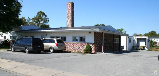
17 Redwood St, Chambersburg, PA 17201


NEARBY LISTINGS FOR SALE OR LEASE
Property Detail
17 Redwood St
04-1D16-030-000000
Sub Plan For Buchanan Homes
Commercialnec
Franklin
X
Pennsylvania
42055C0291E
0.49 AC
2025
Chambersburg/Waynesboro
2025
Philadelphia
011000
Chambersburg, PA
DEMOGRAPHICS near 17 Redwood St
1 Mile
3 Mile
5 Mile
2024 Total Population
13,457
36,461
52,253
2029 Population
13,758
37,112
53,046
Pop Growth 2024-2029
+ 2.24%
+ 1.79%
+ 1.52%
Average Age
38
41
42
2024 Total Households
5,287
14,722
20,967
HH Growth 2024-2029
+ 2.33%
+ 1.77%
+ 1.49%
Median Household Inc
$40,151
$56,803
$62,422
Avg Household Size
2.40
2.40
2.40
2024 Avg HH Vehicles
2.00
2.00
2.00
Median Home Value
$161,246
$202,306
$214,992
Median Year Built
1957
1975
1978
Nearby Places
Map Layers
Map Styles
 Street
 Aerial
- Restaurants
- Banks
- Shops
- Fitness
- Groceries
PUBLIC TRANSPORTATION
AIRPORT
Hagerstown Regional/Richard A Henson Field
DRIVE
WALK
Distance
Hagerstown Regional/Richard A Henson Field
27 min
19.3 mi
Nearby Properties
Address
Land Use
TOTAL SIZE
Lot Size
Zoning
Address
Land Use
TOTAL SIZE
Lot Size
Zoning
20.05 AC
Address
Land Use
TOTAL SIZE
Lot Size
Zoning
Address
Land Use
TOTAL SIZE
Lot Size
Zoning
Address
Land Use
TOTAL SIZE
Lot Size
Zoning
53.99 AC
Address
Land Use
TOTAL SIZE
Lot Size
Zoning
80.09 AC
Address
Land Use
TOTAL SIZE
Lot Size
Zoning
Address
Land Use
TOTAL SIZE
Lot Size
Zoning
20.58 AC
Address
Land Use
TOTAL SIZE
Lot Size
Zoning
71.80 AC
Address
Land Use
TOTAL SIZE
Lot Size
Zoning
39.37 AC
Address
Land Use
TOTAL SIZE
Lot Size
Zoning
36.91 AC
Address
Land Use
TOTAL SIZE
Lot Size
Zoning
60.88 AC
Address
Land Use
TOTAL SIZE
Lot Size
Zoning
121.20 AC
Address
Land Use
TOTAL SIZE
Lot Size
Zoning
Address
Land Use
TOTAL SIZE
Lot Size
Zoning
36.53 AC
Address
Land Use
TOTAL SIZE
Lot Size
Zoning
184.41 AC
Address
Land Use
TOTAL SIZE
Lot Size
Zoning
Address
Land Use
TOTAL SIZE
Lot Size
Zoning
47.56 AC
Address
Land Use
TOTAL SIZE
Lot Size
Zoning
37.36 AC
Address
Land Use
TOTAL SIZE
Lot Size
Zoning
25.25 AC
Address
Land Use
TOTAL SIZE
Lot Size
Zoning
Address
Land Use
TOTAL SIZE
Lot Size
Zoning
30.89 AC
Address
Land Use
TOTAL SIZE
Lot Size
Zoning
Address
Land Use
TOTAL SIZE
Lot Size
Zoning
Address
Land Use
TOTAL SIZE
Lot Size
Zoning
25.15 AC
Address
Land Use
TOTAL SIZE
Lot Size
Zoning
28.83 AC
Address
Land Use
TOTAL SIZE
Lot Size
Zoning
12.78 AC
Address
Land Use
TOTAL SIZE
Lot Size
Zoning
17.04 AC
Address
Land Use
TOTAL SIZE
Lot Size
Zoning
14.94 AC
Address
Land Use
TOTAL SIZE
Lot Size
Zoning
Address
Land Use
TOTAL SIZE
Lot Size
Zoning
The World's #1 Commercial Real Estate Marketplace
Connect with us
© 2026 CoStar Group
The information above has been obtained from sources believed reliable. While we do not doubt its accuracy we have not verified it and make no guarantee, warranty or representation about it. It is your responsibility to independently confirm its accuracy and completeness. Any projections, opinions, assumptions, or estimates used are for example only and do not represent the current or future performance of the property. The value of this transaction to you depends on tax and other factors which should be evaluated by your tax, financial, and legal advisors. You and your advisors should conduct a careful, independent investigation of the property to determine to your satisfaction the suitability of the property for your needs.