Property Record
17 Rice Rd, Rockmart, GA 30153
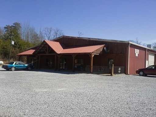

Property Detail
17 Rice Rd
063-009G
TR 1 LL 443
Publicstorage
Polk
B and X Area of moderate flood hazard, usually the area between the limits of the 100-year and 500-year floods.
Georgia
2025
1.83 AC
2025
Georgia Northwest
010100
Other Market Areas
11,520 SF
Cedartown, GA
NEARBY LISTINGS FOR SALE OR LEASE
-
-
View all Rockmart listings for sale on LoopNet.com
DEMOGRAPHICS near 17 Rice Rd
1 mile
3 mile
5 mile
2025 Total Population
127
3,753
13,269
2030 Population
128
3,835
13,724
Pop Growth 2025-2030
+ 0.79%
+ 2.18%
+ 3.43%
Average Age
39
39
40
2025 Total Households
49
1,444
5,070
HH Growth 2025-2030
+ 2.04%
+ 2.15%
+ 3.37%
Median Household Inc
$52,500
$46,218
$55,345
Avg Household Size
2.60
2.60
2.60
2025 Avg HH Vehicles
2.00
2.00
2.00
Median Home Value
$194,999
$186,461
$203,571
Median Year Built
1986
1987
1986
Nearby Places
Map Layers
Map Styles
 Street
 Aerial
Layers
 Traffic
 Biking
Places
Listings with unknown addresses are not visible on the map
- Restaurants
- Banks
- Shops
- Fitness
- Groceries
Nearby Properties
Address
Land Use
TOTAL SIZE
Lot Size
Zoning
Address
Land Use
TOTAL SIZE
Lot Size
Zoning
417,231 SF
43.43 AC
Address
Land Use
TOTAL SIZE
Lot Size
Zoning
27,750 SF
60.84 AC
Address
Land Use
TOTAL SIZE
Lot Size
Zoning
306,003 SF
19.69 AC
Address
Land Use
TOTAL SIZE
Lot Size
Zoning
9,153 SF
10.17 AC
Address
Land Use
TOTAL SIZE
Lot Size
Zoning
30,012 SF
91.47 AC
Address
Land Use
TOTAL SIZE
Lot Size
Zoning
158,416 SF
21.64 AC
Address
Land Use
TOTAL SIZE
Lot Size
Zoning
217,500 SF
28.19 AC
Address
Land Use
TOTAL SIZE
Lot Size
Zoning
99,378 SF
11.99 AC
Address
Land Use
TOTAL SIZE
Lot Size
Zoning
Address
Land Use
TOTAL SIZE
Lot Size
Zoning
14,116 SF
8.12 AC
Address
Land Use
TOTAL SIZE
Lot Size
Zoning
55,115 SF
18 AC
Address
Land Use
TOTAL SIZE
Lot Size
Zoning
44,653 SF
8.18 AC
Address
Land Use
TOTAL SIZE
Lot Size
Zoning
10,425 SF
16.50 AC
Address
Land Use
TOTAL SIZE
Lot Size
Zoning
19,544 SF
12.56 AC
Address
Land Use
TOTAL SIZE
Lot Size
Zoning
22,300 SF
4.33 AC
Address
Land Use
TOTAL SIZE
Lot Size
Zoning
18,116 SF
1 AC
Address
Land Use
TOTAL SIZE
Lot Size
Zoning
4,978 SF
1.70 AC
Address
Land Use
TOTAL SIZE
Lot Size
Zoning
6,043 SF
1.67 AC
Address
Land Use
TOTAL SIZE
Lot Size
Zoning
6,400 SF
1.65 AC
Address
Land Use
TOTAL SIZE
Lot Size
Zoning
2,729 SF
2.91 AC
Address
Land Use
TOTAL SIZE
Lot Size
Zoning
7,405 SF
2 AC
Address
Land Use
TOTAL SIZE
Lot Size
Zoning
7,920 SF
1.80 AC
Address
Land Use
TOTAL SIZE
Lot Size
Zoning
6,250 SF
6.80 AC
Address
Land Use
TOTAL SIZE
Lot Size
Zoning
6,890 SF
1.17 AC
Address
Land Use
TOTAL SIZE
Lot Size
Zoning
4,005 SF
0.96 AC
Address
Land Use
TOTAL SIZE
Lot Size
Zoning
3,851 SF
2.23 AC
Address
Land Use
TOTAL SIZE
Lot Size
Zoning
2,684 SF
0.87 AC
Address
Land Use
TOTAL SIZE
Lot Size
Zoning
13,680 SF
1.05 AC
Address
Land Use
TOTAL SIZE
Lot Size
Zoning
7,266 SF
1 AC
Address
Land Use
TOTAL SIZE
Lot Size
Zoning
5,612 SF
3.97 AC
The World's #1 Commercial Real Estate Marketplace
Connect with us
© 2026 CoStar Group
The information above has been obtained from sources believed reliable. While we do not doubt its accuracy we have not verified it and make no guarantee, warranty or representation about it. It is your responsibility to independently confirm its accuracy and completeness. Any projections, opinions, assumptions, or estimates used are for example only and do not represent the current or future performance of the property. The value of this transaction to you depends on tax and other factors which should be evaluated by your tax, financial, and legal advisors. You and your advisors should conduct a careful, independent investigation of the property to determine to your satisfaction the suitability of the property for your needs.